Grasmoor facts for kids
Quick facts for kids Grasmoor |
|
|---|---|

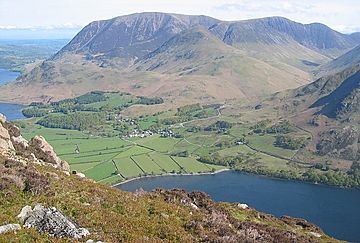
The huge bulk of Grasmoor above
the Crummock Water valley |
|
| Highest point | |
| Elevation | 852 m (2,795 ft) |
| Prominence | 519 m (1,703 ft) |
| Parent peak | Scafell Pike |
| Listing | Marilyn, Wainwright, Hewitt, Nuttall |
| Geography | |
| Location | Cumbria, England |
| Parent range | Lake District, North Western Fells |
| OS grid | NY174203 |
| Topo map | OS Landranger 89, 90, Explorer OL4 |
Grasmoor is a tall mountain located in the north-western part of the Lake District in northern England. It's the highest point in a group of hills found between the villages of Lorton, Braithwaite, and Buttermere. From its slopes, you can look down over the beautiful Crummock Water lake.
Grasmoor is famous for its very steep western side. This side drops sharply down towards Crummock Water. While it's not ideal for rock climbing, the famous fell-walker Alfred Wainwright described a challenging path up this face in his guidebooks. To the east, Grasmoor connects to other fells like Crag Hill through a mountain pass called Coledale Hause. Grasmoor also has some of the largest areas of loose rocks, called scree slopes, in the North Western Fells.
Contents
What's in a Name?
The name Grasmoor comes from an old language called Old Norse. The word grise in Old Norse means wild boar. You can find this old word in other names around the Lake District, like Grisedale Pike and Grizedale Forest.
Exploring Grasmoor's Shape
The North-Western Fells are a group of hills shaped like an oval. They stretch from north to south between the rivers Derwent and Cocker. Two main roads cut across these fells, dividing them into three sections. Grasmoor is located in the middle section.
The highest part of the North-Western Fells is a ridge that runs from east to west. This ridge starts with Grasmoor above Crummock Water. It then gently slopes down towards the east, passing over Crag Hill, Sail, Scar Crags, and Causey Pike. Grasmoor is the highest point on this ridge.
If you start climbing from the valley floor near Little Town in the east, it takes about four miles (6 km) of steady climbing to reach Grasmoor's summit. But if you start from the shores of Crummock Water in the west, you can climb the same height much faster. This is because the western side is very steep and covered in scree.
The very top of Grasmoor is a wide, gently rounded area covered in moss and short grass. There's a narrower part in the middle where a deep bowl-shaped hollow, called Dove Crags, cuts into the northern side. To the east, the slopes are smooth and lead down to a wide, unnamed dip at about 2,368 feet (722 meters). This dip connects Grasmoor to Crag Hill.
At the western end, the summit area becomes narrower. It ends at a smaller peak called Grasmoor End, which is 2,445 feet high. From here, large fans of scree (loose rocks) tumble down to the road by the lake below. Grasmoor also has a smaller ridge that goes southwest over Lad Hows (1,397 feet) before dropping steeply to the valley floor.
To the south of Grasmoor is the Rannerdale valley, which flows into Crummock Water. This valley is fed by Cinderdale Beck, a stream that separates Lad Hows from the main part of the fell. The northern side of the ridge stands above Liza Beck, in the valley of Gasgale Gill. This stream also flows west towards Crummock Water.
How Grasmoor Was Formed
The rocks you see on the surface of Grasmoor are mostly made of something called the Kirkstile Formation. These rocks are from the Ordovician period, which was a very long time ago. They are mostly made of thin layers of mudstone and siltstone. These types of rocks are common in the Skiddaw mountain range.
There's no history of mining under Grasmoor's slopes. The bowl-shaped hollow of Dove Crags is one of the biggest glacial combs or cirques in the Lake District. A cirque is a natural amphitheater-like valley head, formed by glacial erosion. Interestingly, this one doesn't have a lake (tarn) in it. This hollow was formed or made larger by a very big landslide (rock slope failure). Over the last 20,000 years, this landslide has been pushing Liza Beck northward. This has made the Gasgale Gill valley narrower and created the unusually large scree slopes on nearby Whiteside.
Reaching the Top: The Summit View
The highest point of Grasmoor is near the western end of the summit plateau. It's marked by a very large pile of stones called a cairn. You'll see many smaller cairns around too. The top is covered in short, sheep-grazed grass.
The view from the summit is amazing! You can see almost all the major mountain ranges of the Lake District. The only ones you can't see are the Far Eastern Fells. The mountain of High Stile above Crummock Water is a particularly beautiful sight. You can see this best from the western end of the plateau.
Ways to Climb Grasmoor
One clear way to climb Grasmoor is directly up the scree slopes from Lanthwaite, which is on the Crummock Water road. You pick your way through the rocky scenery above to reach Grasmoor End from the northwest. This climb involves going up about 2,000 feet (610 meters) in only about half a mile!
From the same starting point, you can take a longer route along Liza Beck and Gasgale Gill. This gives you access to the northern slopes. From there, you can find a path almost directly to the summit, going around the edge of Dove Crags.
If you start from Rannerdale, you have a couple of choices. You can climb up the Lad Hows ridge, or follow Red Gill a little to the west. Finally, you can use Coledale Hause to reach the main ridge between Crag Hill and Grasmoor. You can get to Coledale Hause from Lanthwaite, or it can be the first goal of a longer walk from Braithwaite in the east. Coledale Hause also connects to Hopegill Head and the fells to the north, offering even more ways to reach Grasmoor.
 | Roy Wilkins |
 | John Lewis |
 | Linda Carol Brown |


