Grisedale Pike facts for kids
Quick facts for kids Grisedale Pike |
|
|---|---|

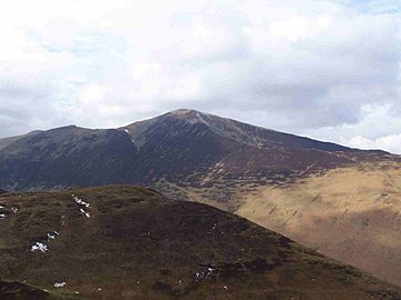
Grisedale Pike seen from the fell
of Barrow, 3 km to the east |
|
| Highest point | |
| Elevation | 791 m (2,595 ft) |
| Prominence | c. 189 m |
| Parent peak | Grasmoor |
| Listing | Marilyn, Hewitt, Wainwright, Nuttall |
| Geography | |
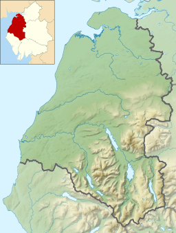
| Location | Cumbria, England |
| Parent range | Lake District, North Western Fells |
| OS grid | NY198225 |
| Listed summits of Grisedale Pike | ||||
| Name | Grid ref | Height | Status | |
|---|---|---|---|---|
| Hobcarton Crag | NY193220 | 739 m (2425 ft) | Hewitt, Nuttall | |
| Hobcarton End | NY194235 | 634 m (2080 ft) | Nuttall | |
Grisedale Pike is a cool mountain in the Lake District in England. It's about 4.5 miles (7.2 km) west of Keswick. This mountain is 791 meters (2,593 feet) tall. That makes it the 40th highest 'Wainwright' mountain in the Lake District!
A 'Wainwright' is a special list of 214 mountains. These were described by Alfred Wainwright in his famous guidebooks. Grisedale Pike also counts as a 'Hewitt', 'Marilyn', and 'Nuttall'. These are other ways to list important hills and mountains.
Grisedale Pike looks really impressive from the east, especially if you are near Keswick. It has two smaller peaks nearby. One is called Hobcarton End.
Contents
Exploring Grisedale Pike
Grisedale Pike is a big mountain with three long ridges. These ridges stretch down to the valley floors. There are also two shorter ridges that connect it to a nearby mountain called Hopegill Head. One important spot is Coledale Hause. This pass links Grisedale Pike to other mountains in the Coledale Fells.
To the south, you'll find the Coledale valley, which is about 2.5 miles (4 km) long. To the north is the Whinlatter Pass. This pass has the B5292 road running through it. The village of Braithwaite sits at the bottom of the long eastern ridge. Some of the northern slopes are covered by a forest called Hospital Plantation.
What the Mountain is Made Of
The rocks on Grisedale Pike are mostly made of a type of mudstone and siltstone. These rocks are part of the 'Skiddaw group'.
The side of the mountain facing Coledale valley has a history of mining. The Force Crag mine was the last working lead mine in the Lake District. It closed in 1990. This mine also dug up zinc and barite. The mine was owned by many different companies over the years. It opened and closed many times since the early 1800s. A big collapse in 1990 caused the owners to close it for good.
Climbing Grisedale Pike
Most people start their climb of Grisedale Pike from the village of Braithwaite. There's a clear path up the eastern ridge. Another way to climb is from a car park in Hospital Plantation. This path goes up the northern ridge. It passes over Hobcarton End before reaching the main summit. You can also climb the fell from the same starting point by following an old stone wall up the north-eastern ridge.
The Coledale Round Walk
Grisedale Pike is often part of a longer circular walk called the Coledale Round. This walk is about 11 miles (17.5 km) long. It starts and finishes in Braithwaite. The Coledale Round includes several other mountains. These are Hopegill Head, Eel Crag, Sail, Scar Crags, and Causey Pike. The whole walk involves climbing over 1,300 meters!
Views from the Top
The view from the top of Grisedale Pike is amazing! You can see the coast of Cumbria to the west. Far away to the east, you might spot the Pennines mountain range.
Grisedale Pike has a smaller peak about 800 meters to the south-west. It's not named on maps, but some people call it Hobcarton Crag. This peak is 739 meters (2,425 feet) tall. It also counts as a 'Nuttall' and 'Hewitt' peak.
From the summit, you can see many famous places. To the north, you might see the Southern Uplands in Scotland. Closer by are the Skiddaw group of mountains and Blencathra. You can also see the Vale of Keswick and Bassenthwaite Lake.
Looking east, the Helvellyn range stands tall. In front of it, you can spot Catbells and Causey Pike. To the south-east, Ingleborough is visible. Then come the Langdale Pikes, the Coniston Fells, Bowfell, and Scafell Pike.
To the south-west, the view is dominated by Crag Hill and Grasmoor. On a very clear day, you might even see a small part of Wales! To the west, above Hopegill Head, you can see the Isle of Man. Sometimes, you can even spot Slieve Donard in Northern Ireland, which is the farthest peak you can see from here.
 | Victor J. Glover |
 | Yvonne Cagle |
 | Jeanette Epps |
 | Bernard A. Harris Jr. |


