
Ingleborough facts for kids
Quick facts for kids Ingleborough |
|
|---|---|

Ingleborough, north face
|
|
| Highest point | |
| Elevation | 723 m (2,372 ft) |
| Prominence | c. 427 m |
| Parent peak | Whernside |
| Listing | Marilyn, Hewitt, Nuttall |
| Geography | |

Ingleborough
Location in Yorkshire Dales
|
|
| OS grid | SD740745 |
| Topo map | OS Landranger 98 |
Ingleborough is a famous mountain in the Yorkshire Dales, England. It stands at 723 m or 2,372 ft tall. This makes it the second-highest mountain in the area. Ingleborough is one of the three special mountains known as the Yorkshire Three Peaks. The other two are Whernside and Pen-y-ghent. Many people enjoy climbing Ingleborough as part of the challenging Three Peaks walk.
Contents
What's in a Name?
The name "Ingleborough" has an interesting history. The first part, "Ingle," might mean 'beacon' or 'fire'. It could also come from an old word meaning 'English'. The second part, "borough," comes from an old English word, burh. This word means "a fortified place" or a strong fort.
This name makes sense because the top of Ingleborough was once a huge hill fort. You can still see the remains of a strong stone wall around the summit. Inside, there are even signs of Iron Age huts.
Exploring Ingleborough's Landscape
Ingleborough is located in the southwest part of the Yorkshire Dales. It's the highest point in a triangle formed by the towns of Ingleton, Ribblehead, and Settle. A lower area, called a col, connects Ingleborough to its taller neighbor, Whernside. This col is near Ribblehead.
The mountain has several ridges and plateaus. To the northeast, a ridge leads to Simon Fell. Another ridge goes southeast, forming two large limestone plateaus. These plateaus include smaller summits like Norber and Moughton. On the slopes of Norber, you can find the famous Norber Boulders. These are large rocks left behind by glaciers.
On the western side of Ingleborough, there's a big limestone area called White Scars. Below this area are the White Scar Caves, which stretch for 4 miles (6.5 km). You can visit the entrance part of these caves as a show cave. This plateau also has a deep hole called Meregill Hole. To the south, there's another plateau with more potholes like Fluted Hole and Pillar Hole.

An area called The Allotment, north of Norber, has many potholes. One of them, Long Kin East, is 100 yards (91 m) long and can be explored without special caving gear. Another is Juniper Gulf, which goes 420 feet (130 m) deep underground. It's a tough, narrow crack in the rock.
Popular Paths to the Summit
There are many popular ways to walk up Ingleborough.
- From Ingleton: A common starting point is the village of Ingleton. This walk is about 7+1⁄2 miles (12 km) round trip. The path goes along a lane, then across a flat area with potholes. A steep climb through limestone cliffs leads to the top.
- From Horton in Ribblesdale: You can also start from Horton in Ribblehead, about 6 miles (10 km) to the east. This route crosses wide areas of limestone pavement. This is the path used when coming down during the Three Peaks Walk. It has been greatly improved over the years.
- From Clapham: Another route starts in Clapham. This path takes you past the Ingleborough Cave and a deep ravine called Trow Gill. It then crosses a marshy area and climbs up to Little Ingleborough before reaching the main summit. The famous Norber erratics can be seen on the way down.
- From Chapel-le-Dale: The northern route starts at the Hill Inn in Chapel-le-Dale. This is the shortest way up, only 3 miles (4.8 km) to the summit. It's part of the Three Peaks Walk. This path crosses a limestone area with many caves, like Great Douk Cave. It then has a steep climb to Simon Fell before a thrilling high-level walk to the top.
What You'll Find at the Top


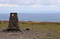
The summit of Ingleborough is a wide, flat area. It's about half a mile around and covered in dry grass. At the highest point, you'll find an Ordnance Survey trig point. This is a special marker used for mapping. Nearby is a well-built windshelter, shaped like a cross to block the wind from any direction. It even has a view indicator in the middle.
There's also a large pile of stones called a cairn. Another even bigger cairn marks where the Ingleton path reaches the top. This bigger cairn is actually what's left of a round tower built in 1830. Sadly, it was destroyed shortly after it was built.
Along the northern and eastern edges of the summit, you can see the remains of an old wall. People once thought it was a Roman army camp. But now we know it was an Iron Age hill fort. This fort covers about 15 acres (61,000 m2) and was likely built by the Brigantes, a powerful Celtic tribe. It's thought that this fort was used all year round, which was unusual for such a high place. The climate was milder back then.
How Ingleborough Was Formed
Ingleborough looks so striking because of the different types of rock it's made of. At the very bottom are ancient Silurian and Ordovician rocks. On top of these is a thick layer of Carboniferous Limestone, about 600 feet (180 m) deep. Because limestone lets water through, streams flowing down the mountain disappear into potholes when they reach this layer.
Above the limestone are layers of sedimentary rocks called the Yoredale Series. These are mostly shale and sandstone. You can see them in the cliffs higher up the mountain. There are also harder limestone layers mixed in. These layers protect the softer rocks below them, creating the mountain's "tiered" or stepped look.
Finally, the whole mountain is protected by a cap of very hard rock called Millstone Grit, about 100 feet (30 m) thick. The rock that was once above this gritstone has worn away, which is why the summit is so flat.
Gallery
-
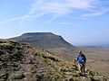
Ingleborough seen on the ascent of Simon Fell
-
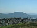
Ingleborough as seen from the summit of Whernside
-
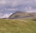
Ingleborough ascent
-
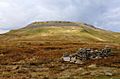
Ingleborough from Little Ingleborough
-
Ingleborough Summit trig point


