Pen-y-ghent facts for kids
Quick facts for kids Pen-y-ghent |
|
|---|---|

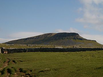
From the path from Horton
|
|
| Highest point | |
| Elevation | 694 m (2,277 ft) |
| Prominence | c. 306 m. (1,004 ft) |
| Parent peak | Whernside |
| Listing | Marilyn, Hewitt, Nuttall |
| Naming | |
| English translation | Hill on the border |
| Language of name | Cumbric |
| Geography | |
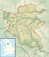
| Location | Yorkshire Dales, England |
| OS grid | SD838733 |
| Topo map | OS Landranger 98 |
Pen-y-ghent is a famous hill in the Yorkshire Dales, England. It is one of the three main peaks in the area. These are known as the Yorkshire Three Peaks. Pen-y-ghent is the lowest of the three. The other two are Ingleborough and Whernside. It stands about 694 meters (2,277 feet) tall. Pen-y-ghent is located near the village of Horton in Ribblesdale. It is a popular spot for hikers and nature lovers.
Contents
What's in a Name?
The name Pen-y-ghent comes from an old language. This language is called Cumbric. It is similar to today's Welsh.
In Cumbric, pen means 'top' or 'head'. The word y most likely means 'the'. The last part, ghent, probably means 'edge' or 'border'. So, the name Pen-y-ghent could mean 'Hill on the border'. You might also see the name written as Pen y Ghent.
Exploring Pen-y-ghent's Geography
Pen-y-ghent is made of two main types of rock. The top part is a hard rock called millstone grit. Below that is a softer rock called carboniferous limestone.
The top of the hill acts like a giant split. Water flows in two different directions from here. Some water flows east into the River Skirfare. This river eventually reaches the Humber Estuary. Other water flows west into the River Ribble. This river flows all the way to the Irish Sea.
Hull Pot: England's Largest Natural Hole
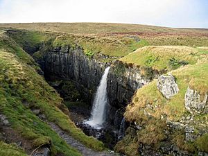
One cool feature is Hull Pot. It is the biggest natural hole in England. Hull Pot is about 91 meters (300 feet) long. It is also 18 meters (60 feet) wide and 18 meters (60 feet) deep.
A stream called Hull Pot Beck flows into Hull Pot. After going underground, the water reappears as Brants Ghyll Beck. This then flows into the River Ribble.
Long ago, people noticed something strange. They said water from Hull Pot and another nearby hole, Hunt Pot, crossed underground without mixing. This was tested by making one stream muddy and putting oat husks in the other. Both came out without mixing.
Hiking Pen-y-ghent
Pen-y-ghent is a popular place for hillwalking. Many people hike to its summit. The Pennine Way is a famous long-distance path. It goes right over the top of Pen-y-ghent.
The most common way to hike Pen-y-ghent is from Horton in Ribblesdale. This route is about 5 kilometers (3 miles) long. It first curves north before turning east to reach the top.
The Yorkshire Three Peaks Challenge
Pen-y-ghent is part of the Yorkshire Three Peaks Challenge. This challenge involves hiking Pen-y-ghent, Ingleborough, and Whernside in one day. Most people do this challenge by starting and finishing in Horton in Ribblesdale. They usually walk in an anti-clockwise direction.
Another hiking route goes north from the summit. It leads to Plover Hill. From there, you can go down to Foxup Road. This is a bridleway at the head of Littondale.
 | DeHart Hubbard |
 | Wilma Rudolph |
 | Jesse Owens |
 | Jackie Joyner-Kersee |
 | Major Taylor |


