
Littondale facts for kids
Littondale is a beautiful valley in North Yorkshire, England. It's part of the Yorkshire Dales area. In this valley, you'll find small villages like Hawkswick, Arncliffe, Litton, Foxup, and Halton Gill. Many old farmhouses from the 1600s are also here. The main river flowing through Littondale is the River Skirfare. Many smaller streams feed into it.
The name "Littondale" was first written down in 1198. It's special because it's named after its main village, Litton, not its river. Most valleys are named after their rivers, like Wensleydale. Long ago, this valley was also called "Amerdale." The famous TV show Emmerdale was first filmed in Arncliffe, and its name might come from "Amerdale."
Contents
Exploring Littondale's Landscape
Littondale is a valley that branches off to the west of Wharfedale. The River Skirfare flows through it. The valley's smooth, rounded shape was created by many ice ages. The last big one was about 20,000 years ago. As the huge glacier melted and moved back, it left behind piles of rock and soil. You can see an example of this near Skirfare Bridge.
Just like its neighbor, Wharfedale, Littondale is mostly made of two types of rock: Great Scar Limestone and Yoredale rock. Because of the limestone, the valley has many interesting features. These include shake holes and sink-holes. These are natural dips in the ground that can lead to underground cave systems, like Boreham Cave. At the very top of the valley is Pen-y-ghent. This is one of the famous Yorkshire Three Peaks mountains.
A narrow road goes up the valley from the B6160 road near Kilnsey all the way to Foxup. Two smaller roads also lead out of the valley. One goes from Arncliffe to Malham in the south. The other goes from Halton Gill past Pen-y-Ghent to Stainforth in Ribblesdale.
Littondale's Long History
Littondale has been home to people for a very long time. There are signs of settlements from the Bronze Age and Iron Age, which means people lived here over 5,000 years ago. It was a safe and fertile valley. You can still see old farming terraces, called lynchets, created by the Angles.
After the Norman Conquest, the Normans used the valley as a hunting area. Then, in the 1200s, the land was given to the monks of Fountains Abbey. They used the valley a lot for raising sheep.
Historically, all of Littondale was part of the old church area (parish) of Arncliffe in the West Riding of Yorkshire. Later, in 1866, it was split into smaller local areas called civil parishes: Hawkswick, Arncliffe, Litton, and Halton Gill. In 1974, these areas became part of the Craven district in the new county of North Yorkshire.
Villages of Littondale
Here are the main villages you'll find as you travel up Littondale from the B6160 road:
Hawkswick
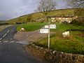
Hawkswick is the first village you reach. Its name comes from old words meaning "someone who trained hawks" and "dairy farm."
Arncliffe
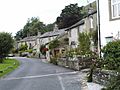
Arncliffe is the second and largest village. It sits where Cowside Beck stream joins the River Skirfare. Its name means "eagles cliff" from Old English. Today, Arncliffe is a special conservation area. It has a lovely village green and one pub. The church there was built in the 1500s and 1700s. It replaced an older stone church from the 1000s, which probably replaced an even older wooden Anglo-Saxon church.
Litton
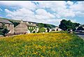
Litton is the third village you'll come to. Its name means "village on a roaring stream," which fits the sound of the water nearby.
Halton Gill
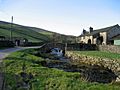
Halton Gill is the fourth village. Its name comes from old Anglo-Saxon words. "Haugh" means "valley" and "tun" means "farm." "Gill" comes from an old Norse word meaning "ravine." So, the full name means "valley farm by the ravine."
Foxup
Foxup is the last village at the top of the valley. Its name simply means "fox valley."
How Littondale is Governed
Littondale is part of the Mid Craven area for the North Yorkshire County Council. In 2020, Gill Quinn from the Conservative Party was the county councillor.
It's also part of the Upper Wharfedale area for the Craven District Council. As of 2020, Sue Metcalfe from the Conservative Party represented this area.
There are four local areas, called civil parishes, in Littondale. Arncliffe has a parish council, which helps make decisions for the village. Hawkswick, Litton, and Halton Gill have parish meetings. These are like smaller community meetings where people can discuss local issues.
Gallery
-
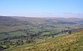
Littondale. Seen from above Hawkswick on the path from Kettlewell.
-
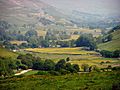
View down Littondale
-
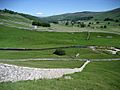
View up Littondale. Looking north-westwards from footpath corner at MR: SD916739.
-
View up Littondale. Looking up dale from the Monks Road in a north-westerly direction.
-
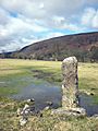
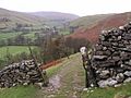
Stone pillar, Littondale near Hawkswick Bridge.
-
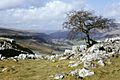
Littondale (N Yorkshire).View from near the Hawkswick to Malham footpath.
-
Hawkswick
-
Arncliffe
-
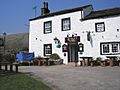
The Queen's Arms, Litton
-
Halton Gill
-
Foxup


_-_geograph.org.uk_-_432719.jpg)


