
Yorkshire Three Peaks facts for kids

The Three Peaks are three famous mountains in the Yorkshire Dales National Park in Northern England. They are Whernside, Ingleborough, and Pen-y-ghent. These peaks are part of the Pennines mountain range. They stand around the top of the River Ribble valley.
Whernside is the tallest at 736 meters (2,415 feet). Ingleborough is 723 meters (2,372 feet) high. Pen-y-ghent reaches 694 meters (2,277 feet).
Contents
What's in a Name?
People in the local area have always known these mountains as "The Three Peaks." But now, there are other "National" Three Peaks challenges. These involve Ben Nevis in Scotland, Snowdon in Wales, and Scafell Pike in England.
To avoid confusion, people often add "Yorkshire" to the name. So, they are called the "Yorkshire Three Peaks." Even though part of Whernside is in Cumbria, the whole mountain is considered part of historic Yorkshire.
How the Mountains Were Formed
The Three Peaks are made from layers of sedimentary rock. These rocks formed a very long time ago, during the Carboniferous period. The lower parts of the mountains are made of thick limestone.
Higher up, the mountains have layers of limestone mixed with mudstone and sandstone. These different layers give Ingleborough and Pen-y-ghent their unique stepped look. The very tops of the mountains are covered by a hard rock called Grassington Grit.
Amazing Caves and Waterfalls
The limestone in these mountains has many caves and potholes. These are popular with cavers from all over the country. One famous spot is Gaping Gill. Here, a stream called Fell Beck drops 110 meters (361 feet) straight down into a huge cave.
You can even visit part of this cave system at Ingleborough Cave. There, you can take a guided tour to see the floodlit underground passages.
A Look at History
The area around the Three Peaks has a lot of history. On top of Ingleborough, you can still see the remains of a huge Iron Age hill fort. This shows that people lived here thousands of years ago.
The famous Settle-Carlisle Railway also runs between these mountains. It crosses the impressive Ribblehead Viaduct near the base of Whernside.
Fun Activities and Challenges
The Three Peaks area is a great place for outdoor activities. Many people come here to walk, hike, and even race.
Long-Distance Walking Trails
- The Pennine Way is a long walking path that goes through the village of Horton. It also crosses the summit of Pen-y-ghent.
- The Ribble Way follows the River Ribble. It starts near Whernside and goes all the way to the river's mouth near Preston.
The Three Peaks Walk Challenge
The Three Peaks walk is a very popular challenge. It involves hiking up all three mountains in one day. The first recorded time someone completed this walk was in 1887. It took them 10 hours.
The walk is about 37.5 to 42 kilometers (23 to 26 miles) long. You also climb and descend nearly 1,600 meters (5,249 feet). Many walkers try to finish the route in under 12 hours.
Most people start the walk in the village of Horton-in-Ribblesdale. In the past, the Pen-y-ghent Cafe in Horton used to record walkers' times. This allowed them to join a special club.
The Yorkshire Dales National Park has a project called Friends of the Three Peaks. If you join, your money helps to keep the paths on the route in good condition.
Exciting Races
Besides being a walking challenge, the Three Peaks route is also used for races.
- The Three Peaks Race is a famous fell running event. It has been held every year since 1954.
- The Three Peaks Cyclo-Cross race is for cyclists. It follows a longer route of 61 kilometers (38 miles) across the peaks.
The Three Peaks on TV
The Three Peaks were featured on a TV show called Seven Natural Wonders. They were shown as one of the natural wonders of Yorkshire.
Images for kids
-
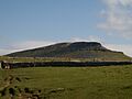
Pen-y-ghent
-
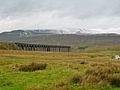
Whernside
-
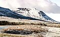
Ingleborough


| Point | Coordinates (Links to map resources) |
OS Grid Ref | Notes |
|---|---|---|---|
| Whernside | 54°13′40″N 2°24′09″W / 54.227730°N 2.402498°W | SD73868141 | |
| Ingleborough | 54°10′00″N 2°23′52″W / 54.166564°N 2.397793°W | SD74137460 | |
| Pen-y-ghent | 54°09′22″N 2°14′55″W / 54.156006°N 2.248735°W | SD83857338 |
