Whernside facts for kids
Quick facts for kids Whernside |
|
|---|---|

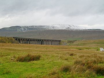
A snow-covered Whernside and Ribblehead
Viaduct seen from Ribblehead |
|
| Highest point | |
| Elevation | 736 m (2,415 ft) |
| Prominence | 408 m (1,339 ft) |
| Parent peak | Cross Fell |
| Listing | Marilyn, Hewitt, Hardy, County Top, Nuttall |
| Geography | |
| OS grid | SD738814 |
| Topo map | OS Landranger 98 |
Whernside is a tall mountain located in the beautiful Yorkshire Dales in Northern England. It stands as the highest of the famous Yorkshire Three Peaks, which also include Ingleborough and Pen-y-ghent. Whernside is the highest point in the county of North Yorkshire and the historic West Riding of Yorkshire. Its summit (the very top) sits right on the border with Cumbria.
Whernside has a long, ridge-like shape. It stretches roughly from the north-north-east to the south-south-west. The mountain is about 10 kilometers (6 miles) northwest of Ingleton. It is also about 10 kilometers (6 miles) north of Horton-in-Ribblesdale.
Contents
Climbing Whernside
Many people enjoy hiking up Whernside. There are several paths you can take to reach the top.
Popular Paths
One common way to climb Whernside starts from the east, near Ribblehead. This path goes north through areas like Smithy Hill. It then turns west towards Knoutberry Haw before heading south to the summit of Whernside.
If you are doing the Yorkshire Three Peaks Challenge, you will usually climb Whernside using this route from Ribblehead. After reaching the top, the path goes south. It then steeply descends southeast down a stepped path to an area called Bruntscar.
Other Ways to Explore
Besides the main paths, there are other routes you can use. These paths cross "open access land," which means you are allowed to walk there. One path goes directly west from the triangulation pillar (a marker at the summit). This path leads towards Deepdale Lane.
Another option is to head north across Knoutberry Haw. This route passes by Whernside Tarns (small mountain lakes). It eventually reaches the Craven Way.
Longer Walks
A walk that just focuses on Whernside can start near the Station Inn at Ribblehead. You can walk to the top of Whernside and then return. This return path goes via Bruntscar and passes several farms. This whole walk is about 8.5 miles (13.7 kilometers) long.
The famous walker Alfred Wainwright wrote about Whernside in his 1970 book, Walks in Limestone Country. He described three different walks to the summit. One walk from Ingleton was 14.25 miles long. He called it "an exhilarating walk." Another route from Dent was 10.5 miles long. He said it offered "excellent views." He also described the 7.5-mile ascent from Ribblehead.
What You Can See
On a clear day, the views from the top of Whernside are amazing. Looking west, you can see the beautiful Lake District and Morecambe Bay. If you use binoculars, you might even spot Blackpool Tower, which is about 40 miles (64 kilometers) away!
Whernside is located about 2 miles (3.2 kilometers) northwest of the impressive Ribblehead Viaduct. This viaduct is a large bridge that carries the Settle–Carlisle Railway.
About the Name
Whernside is sometimes confused with a smaller mountain called Great Whernside. Great Whernside is about 17 miles (27 kilometers) to the east. The word "Whern" in Whernside is thought to come from "querns." Querns were special stones used to grind grain. The word "side" comes from an old Norse word, "sættr." This word means an area of summer pasture for animals.
 | Aaron Henry |
 | T. R. M. Howard |
 | Jesse Jackson |


