
Wharfedale facts for kids
Quick facts for kids Wharfedale |
|
|---|---|
.jpg)
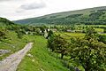
Wharfedale near Buckden
|
|
| Length | 50 mi (80 km) |
| Geography | |
| Location | Yorkshire, England |
| District | North and West Yorkshire |
| River | River Wharfe |
Wharfedale is a beautiful valley in Yorkshire, England. It's where the upper part of the River Wharfe flows, and it's one of the famous Yorkshire Dales. The valley stretches across parts of North Yorkshire and West Yorkshire.
Many towns and villages are found along the river. These include Buckden, Kettlewell, Grassington, Bolton Abbey, Ilkley, Otley, and Wetherby. After Wetherby, the valley opens up into the wider Vale of York.
The part of the valley from the river's start down to Addingham is called Upper Wharfedale. This area is mostly in North Yorkshire and within the amazing Yorkshire Dales National Park. The first 15 miles (24 km) of the river's journey is known as Langstrothdale. Here you'll find small places like Beckermonds and Hubberholme. Hubberholme is famous for its church, which is the resting place of the writer J. B. Priestley.
As the River Wharfe turns south, it flows through a green and rich valley. You can see cool limestone rock formations, like Kilnsey Crag. There are also more woodlands here than in other parts of the Dales.
Below Addingham, the valley gets wider and turns towards the east. This section is shared between North and West Yorkshire. It includes bigger towns like Ilkley, Otley, and Wetherby. The northern side of this lower part of Wharfedale, across from Ilkley and Otley, is part of the Nidderdale Area of Outstanding Natural Beauty.
The Yorkshire Dales Rivers Trust helps protect the rivers and nature in Wharfedale. They work to keep the rivers clean and healthy from their beginnings all the way to the Humber Estuary.
Contents
Wharfedale's Ancient History

The amazing shape of the Wharfedale valley was created during the last ice age. This period, called the Devensian Glaciation, happened between 18,000 and 12,000 years ago. A huge glacier, the Wharfedale Glacier, carved out the valley into its classic U-shape. Before this, a river already flowed through the area.
People have lived in this valley for a very long time. Evidence of human homes has been found from Neolithic times, which was the New Stone Age. There are also many old items from the Celtic, Roman, and Anglo-Saxon periods. The Romans even built a road over Stake Moss to what is now the village of Bainbridge in Wensleydale. The names of many villages in Upper Wharfedale today still come from the Anglo-Saxon language.
Understanding the Name Wharfedale
The name Wharfedale comes from the main river that flows through it: the River Wharfe. The word Wharfe comes from old languages. In Old English, it was Weorf, and in Old Norse, it was Hverfr. Both of these words mean winding river, which perfectly describes how the river flows!
The River Wharfe begins where two smaller streams meet at a tiny village called Beckermonds. These streams, the Oughtershaw Beck and the Green Field Beck, start high up in the Pennines mountains. The valley generally runs towards the southeast. It also forms a natural border between West Yorkshire and North Yorkshire. From its start to Wetherby, the valley stretches for about 50 miles (80 km). The very top part of the valley is known as Langstrothdale.
For centuries, people have used the valley mainly for farming. You can still see many old stone walls and barns that show how the land has been used over time.
Wharfedale's Geology: Rocks and Landscapes
The rocks that make up Wharfedale are different in different parts of the valley. In Upper Wharfedale, the ground is mostly made of carboniferous limestone. This type of rock is often found in the Yorkshire Dales.
In the lower part of Wharfedale, around Ilkley and Otley, the rocks are mostly a type called millstone grit. You can see this rock clearly at the famous Cow and Calf rocks. These rocks are on the south side of the valley, on Ilkley Moor.
Wharfedale in Art and Culture

Wharfedale has inspired many famous artists. John Atkinson Grimshaw, a well-known painter from the Victorian era, painted the area in his piece "Moonlight, Wharfedale" (1871). He was famous for his amazing paintings of night scenes and towns. This painting shows how skilled he was.
Another famous artist, J. M. W. Turner, also visited Wharfedale. He painted scenes around Otley and Ilkley. Turner was asked to paint Kilnsey Crag, and he created a beautiful oil painting of it in 1816.
The valley has also been featured on television. It appeared in episode three of the BBC Two series, The Yorkshire Dales.
Images for kids
-
Wharfedale near Buckden
-
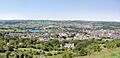
The broad sunlit uplands of Lower Wharfedale above Otley
-
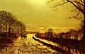
John Atkinson Grimshaw - Wharfedale 1872
