Sail (Lake District) facts for kids
Quick facts for kids Sail |
|
|---|---|
 |
|
| Highest point | |
| Elevation | 773 m (2,536 ft) |
| Prominence | c. 32 m |
| Parent peak | Crag Hill |
| Listing | Wainwright, Hewitt, Nuttall |
| Geography | |
| Location | Cumbria, England |
| Parent range | Lake District, North Western Fells |
| OS grid | NY198204 |
| Topo map | OS Landranger 89, 90, Explorer OL4 |
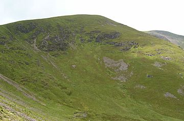
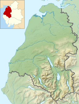
Sail is a cool hill located in the amazing Lake District in England. It sits right between two beautiful lakes, Derwentwater and Crummock Water.
Contents
Where is Sail?
Sail is a hill in the North Western Fells part of the Lake District. This area is like a big oval of hills between the Derwent and Cocker rivers. Two main roads cut through these hills, splitting them into three sections. Sail is in the middle section, between Whinlatter Pass and Newlands Pass.
The highest part of the North Western Fells is a ridge that goes from east to west. It starts at Grasmoor near Crummock Water. Then it gently slopes down through Crag Hill, Sail, Scar Crags, and Causey Pike.
Sail is very close to Crag Hill, almost like its smaller companion. Even though it's smaller, it's tall enough to be called a Hewitt! From the top of Crag Hill, the ridge gets narrower and rocky. This rocky part is called The Scar.
The rough ground gets smoother as you reach the rounded top of Sail. After Sail, the ridge turns towards the east-northeast. There's a dip in the ground before you reach the top of Scar Crags. This dip is called Sail Pass.
Sail also has a connection to the south of the main ridge. This high path leads to Ard Crags. Ard Crags and its neighbor, Knott Rigg, form another ridge that runs next to the main one.
Water Flowing from Sail
The water that flows north from Sail goes into a long, empty valley called Coledale. This valley ends near the village of Braithwaite. Near the top of Coledale, there are two waterfalls.
The southern parts of Sail are drained by Sail Beck and its smaller streams. These flow southwest between the slopes of Wandope and Knott Rigg. They end up at Buttermere village. This means Sail is on the main dividing line for water in the North Western Fells.
Sail's sides are steep and rough all around. The ridge leading to Crag Fell has rocky edges, with Scott Crag to the north and Scar Crag to the south. Another important rocky face is Long Crag, which looks over High Moss.
What is Sail Made Of?
The top parts of Sail are made of a type of rock called the Kirkstile Formation. This rock is common in the Skiddaw fells. It's made of layers of mudstone and siltstone. Below this, you'll find sandstone from the Loweswater Formation.
A crack in the earth, called the Causey Pike Fault, runs across the southern side of the hill. Beyond this fault, the rocks are from the Buttermere Formation. This is a mix of broken and folded mudstone, siltstone, and sandstone.
On the north side of Sail Pass, you can find the remains of an old cobalt mine. This mine was opened in 1848. People spent a lot of money building roads and processing plants for it. However, it mostly contained arsenic instead of cobalt. The mine was quickly closed because it didn't produce much cobalt. You can still see some of the old mine entrances today.
Another mine, Force Crag mine in Coledale, was much more successful. However, that mine is closer to Hopegill Head.
Reaching the Top of Sail
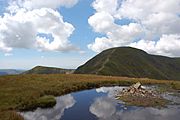
The very top of Sail is a rounded, heathery area with a small pile of stones called a cairn. The main path along the ridge goes a little to the south of the summit. This path is quite worn down from people walking on it to get to Crag Hill.
The view from the top is amazing, except where Crag Hill blocks it. To the north, you can see the whole of Coledale valley. To the east, you can see the long Helvellyn range above Catbells. Looking south, you can see the tall fells around Ennerdale, Wasdale, and Eskdale.
From the summit, you can also spot Bassenthwaite Lake. If you walk a few steps, you can also see Buttermere and Derwentwater.
How to Hike Up Sail
Most hikers reach Sail by walking along the ridge, either starting from Grasmoor or Causey Pike. If you want to go straight up from the northeast, you can start from Braithwaite or Stair. From Braithwaite, you would first head towards High Coledale Farm. Then you cross the Outerside ridge near Stile End. The path then goes up to Sail Pass from the north.
If you start from Stair, the Stoneycroft Mine Road also leads to Sail Pass. This route takes you past the old cobalt mine. From Buttermere village, you can take a long walk up Sail Beck. This path goes "behind" Ard Crags and reaches Sail Pass from the other side.
 | Stephanie Wilson |
 | Charles Bolden |
 | Ronald McNair |
 | Frederick D. Gregory |


