Wandope facts for kids
Quick facts for kids Wandope |
|
|---|---|

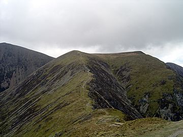
Whiteless Edge & Wandope from Whiteless Pike
|
|
| Highest point | |
| Elevation | 772 m (2,533 ft) |
| Prominence | c. 30 m |
| Parent peak | Crag Hill |
| Listing | Wainwright, Hewitt, Nuttall |
| Geography | |
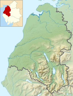
| Location | Cumbria, England |
| Parent range | Lake District, North Western Fells |
| OS grid | NY188197 |
| Topo map | OS Landranger 89, Explorer OL4 |
Wandope (also called Wanlope or Wandhope) is a mountain, or "fell," in the north-western part of the Lake District in England. It sits to the east of Crummock Water and south of Crag Hill. From the top of Wandope, you can see amazing views of other famous mountains like the Sca Fell and High Stile ranges.
Contents
Exploring the North Western Fells
The North Western Fells are a group of hills found between two rivers, the Derwent and the Cocker. This area is shaped like a long oval, stretching from north to south. Two main roads cross this region, dividing the fells into three easy-to-understand groups. Wandope is located in the middle section, between Whinlatter Pass and Newlands Pass.
The highest ground in the North Western Fells is a ridge that runs from east to west. It starts with Grasmoor above Crummock Water and then gently slopes down towards the east. This ridge includes Crag Hill, Sail, Scar Crags, and Causey Pike. While Grasmoor is the tallest, Crag Hill is like the central point of this mountain range. From Crag Hill, another ridge branches off to the southwest, leading down to Wandope and Whiteless Pike, and then towards the village of Buttermere.
Wandope's Unique Shape
Wandope doesn't always stand out when you look at it from below. From most directions, it seems smaller than its taller neighbours. The path connecting Wandope to Crag Hill is a wide, flat area called Wandope Moss, which slopes gently to the west.
On the other side of Wandope, you'll find a striking feature called Addacomb Hole. This valley looks like half of a crater, with its back wall rising about 700 feet high. It's a very interesting natural shape.
The ridge that goes southwest from Wandope is split into two parts by a stream called Third Gill. The eastern part is a short, blunt spur. However, the western part narrows into a beautiful, open ridge known as Whiteless Edge. This ridge leads directly to the top of Whiteless Pike, crossing a dip called Saddle Gate (which is 2,065 feet high). The sides of this ridge are steep and rugged, with more exposed rocks on the eastern side.
All the water that runs off Wandope eventually flows into Crummock Water. The main water divide between the Derwent and Cocker rivers actually goes from Crag Hill to Ard Crags, bypassing Wandope. Sail Beck carries water from the south and east, flowing between Knott Rigg and Whiteless Pike into Buttermere village. Addacomb Beck and Third Gill are smaller streams that mark the northern and southern edges of Wandope on this side. To the north and west of the fell, Rannerdale Beck flows directly into the middle part of Crummock Water.
What Wandope is Made Of
The top parts of Wandope are made of a type of rock called the Kirkstile Formation. This rock is common in the Skiddaw fells and is made up of thin layers of mudstone and siltstone. Below this, you'll find sandstones from the Loweswater Formation. A geological break, known as the Causey Pike Fault, runs across the southern slopes of Wandope. Beyond this fault, the rocks change to those of the Buttermere Formation.
The Summit View
At the very top of Wandope, a small pile of stones, called a cairn, marks the summit. It's on a gentle, grassy dome, just a few steps from the edge of Addacomb Hole. While the view to the north is blocked by Grasmoor and Crag Hill, you can see a wonderful mountain landscape in all other directions. The Scafells are often considered the most impressive sight from this spot.
How to Climb Wandope
The village of Buttermere is the best place to start your climb up Wandope. There are several paths you can take.
- You can follow Sail Beck and then Third Gill. This path will lead you to the shorter eastern part of the southwest ridge.
- Another option is to follow Sail Beck further up the valley until you reach Addacomb Beck. Above this point, you'll see a clear ridge that goes around the southern edge of Addacomb Hole.
Many people also choose to climb Wandope as part of a longer hike. You can add it to a trip along the Grasmoor-Causey Pike ridge, or include it in a circular walk around Rannerdale.
 | Delilah Pierce |
 | Gordon Parks |
 | Augusta Savage |
 | Charles Ethan Porter |


