Whiteless Pike facts for kids
Quick facts for kids Whiteless Pike |
|
|---|---|

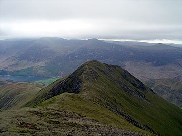
Whiteless Pike from Whiteless Edge
|
|
| Highest point | |
| Elevation | 660 m (2,170 ft) |
| Prominence | c. 35 m |
| Parent peak | Crag Hill |
| Listing | Wainwright, Hewitt, Nuttall |
| Geography | |
| Location | Cumbria, England |
| Parent range | Lake District, North Western Fells |
| OS grid | NY180189 |
| Topo map | OS Landranger 89, Explorer OL4 |
Whiteless Pike is a mountain, or "fell," found in the beautiful Lake District in northwest England. It stands 660 metres (2,165 feet) tall.
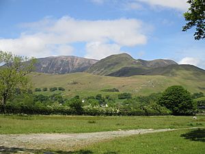
This fell is located just east of Crummock Water. If you look at it from Rannerdale, it has a cool pyramid shape. A famous guide writer, Alfred Wainwright, even called it the "Weisshorn of Buttermere" because of its striking look. From the top, you can see amazing views of other big mountains like Great Gable and the Scafells.
Contents
Where is Whiteless Pike?
The North Western Fells are a group of hills in the Lake District. They are found between two rivers, the Derwent and the Cocker. This area is shaped like a long oval, running north to south.
Two main roads cut across these fells from east to west. These roads divide the hills into three easy-to-understand sections. Whiteless Pike is in the middle section, located between Whinlatter Pass and Newlands Pass.
How the Mountain is Shaped
The highest part of the North Western Fells is a ridge that runs from east to west. This ridge starts with Grasmoor above Crummock Water. It then gently slopes down towards the east, passing over Crag Hill, Sail, Scar Crags, and Causey Pike.
Even though Grasmoor is the highest, Crag Hill is like the main hub of this mountain range. From Crag Hill, another ridge branches off to the southwest. This ridge steps down through Wandope and then reaches Whiteless Pike. Finally, it continues down towards the village of Buttermere.
From the wide, flat area of Wandope, a narrow and exciting ridge called Whiteless Edge goes southwest. It drops down to a lower spot called Saddle Gate. After a short climb, you reach the very top of Whiteless Pike. The ridge then turns south and goes down to a wide, flatter area known as Whiteless Breast. From here, the slope continues all the way down to Buttermere village.
However, the ridge doesn't end there! It makes a sharp turn to the northwest and keeps going to Rannerdale Knotts. Both sides of this ridge are very steep.
Water Flowing Down
The eastern side of Whiteless Pike has several small streams. These streams flow into Sail Beck, which then goes into Crummock Water near Buttermere Village.
The northwestern slopes of the fell feed into Rannerdale Beck. This is another stream that flows into Crummock Water. It runs between Whiteless Pike and Grasmoor. The sharp bend in the ridge, between Whiteless Pike and Rannerdale Knotts, is where Squat Beck starts. Squat Beck is a smaller stream that joins Rannerdale Beck.
What the Summit is Like
The very top of Whiteless Pike is small and pointed. It is covered with loose stones and has a cairn, which is a pile of stones often used as a marker.
Because the slopes are so steep, they make the views from the top even more dramatic. You get a fantastic view of the Scafells, which are some of England's highest mountains. You can also see the Helvellyn range and the Western Fells very clearly. The only slight disappointment might be the close-up view of Grasmoor, which can look a bit plain. But overall, the views of Buttermere, Crummock, and Loweswater lakes are amazing.
How to Climb Whiteless Pike

The easiest place to start your climb is from the village of Buttermere. There is a good path that goes up Whiteless Breast and then onto the main ridge.
You can also start from the shore of Crummock Water. From there, you can enter Rannerdale. You would then turn off and follow Squat Beck upwards. This path leads you to the bend in the ridge between Rannerdale Knotts and Whiteless Pike. Some people also enjoy making a full loop around Rannerdale by walking along the entire ridge of Rannerdale Knotts.
 | Claudette Colvin |
 | Myrlie Evers-Williams |
 | Alberta Odell Jones |


