Rannerdale Knotts facts for kids
Quick facts for kids Rannerdale Knotts |
|
|---|---|

Rannerdale Knotts (centre right) from Haystacks
|
|
| Highest point | |
| Elevation | 355 m (1,165 ft) |
| Prominence | c. 70 m |
| Parent peak | Crag Hill |
| Listing | Wainwright |
| Geography | |
| Location | Cumbria, England |
| Parent range | Lake District, North Western Fells |
| OS grid | NY167182 |
| Topo map | OS Landranger 89, Explorer OL4 |
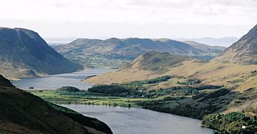
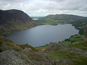
Rannerdale Knotts is a small mountain, called a fell, located in the beautiful Lake District area of Cumbria, England. It rises from the Buttermere valley and is surrounded by much taller fells like Grasmoor and Whiteless Pike. Across Crummock Water, you can see Mellbreak and the High Stile ridge. Rannerdale Knotts is famous for a story about a big battle that supposedly happened here a long, long time ago, between local Cumbrians and invaders.
Contents
What Rannerdale Knotts Looks Like
The North Western Fells are a group of hills found between two rivers, the Derwent and the Cocker. Imagine a big, oval-shaped area of hilly land. Roads cut through this area, dividing the fells into three main parts. Rannerdale Knotts is in the central part.
The highest ground in this area is a ridge that goes from east to west. It starts with Grasmoor and then gently slopes down through other fells like Crag Hill and Sail. Crag Hill is like the main hub of these fells. From Crag Hill, another ridge stretches out to the southwest, going down past Wandope and Whiteless Pike towards Buttermere village. Just before the village, this ridge makes a sharp turn and goes up again to the top of Rannerdale Knotts.
There's a dip in the ridge at about 950 feet high. After this dip, the ground slowly climbs for about a mile towards the top. This part of the fell is called Low Bank on maps and is covered in a plant called bracken. The very last part of the climb has several rocky bumps, or "knolls," that keep rising. Then, the ridge drops steeply down to the valley floor, right by Crummock Water. A farm called Rannerdale is located at the bottom of this steep slope.
On one side, Rannerdale Knotts is bordered by Mill Beck, a small stream that runs through Buttermere village, and then by Crummock Water. On the other side, it slopes down to Squat Beck, which flows into Rannerdale Beck. The area called High Rannerdale is nestled between Whiteless Pike and Rannerdale Knotts. Rannerdale itself is a triangular patch of green land surrounded by Rannerdale Knotts, Grasmoor, and Crummock Water.
Rocks and Mines

The top part of Rannerdale Knotts is made of a type of rock called Kirkstile Formation. These rocks are very old, from a time called the Ordovician period. They are mostly made of thin layers of mudstone and siltstone. The area called Low Bank is different; it's part of the Buttermere Formation, which is a mix of broken and folded mudstone, siltstone, and sandstone. There are also a couple of small areas where basalt rock has pushed through the ground.
There's an old, small mine tunnel in the rocky cliffs on the northern side, above Hause Point, near the road by Crummock Water. The opening is about 5 feet wide, but the tunnel doesn't go very far into the fell. It seems people were looking for lead here, and you can still find some traces of it.
Reaching the Top
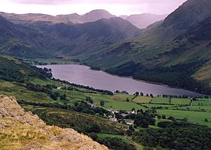
The very top of Rannerdale Knotts is a small, neat area on the highest rocky bump. There's a pile of stones, called a cairn, marking the summit. From here, your view is a bit limited by the taller fells around you. However, the view of Buttermere village and lake, with the big fells of Great Gable behind them, is amazing! If you walk a few steps to the west, you can also get a great view of Crummock Water.
How to Climb Rannerdale Knotts
People often start their climb to Rannerdale Knotts from Buttermere village. They follow a good path that goes up Whiteless Pike, then turn west-northwest along Low Bank at the dip in the ground, which is about 950 feet high. You can also climb directly up the western side of the fell from Hause Point at Rannerdale. This spot is reached from the B5289 road, which runs along the eastern shore of Crummock Water. For a longer adventure, you can do a big loop around Rannerdale, which includes climbing Grasmoor, Crag Hill, Wandope, Whiteless Pike, and Rannerdale Knotts.
The Battle of Rannerdale: A Secret Valley Story
A local historian and a man who ran a pub, Nicholas Size, wrote a historical novel in 1930 called The Secret Valley. This book tells a fascinating story about how the people in this area fought against the Norman invaders. This was about 50 years after the famous Norman invasion of England in 1066. According to Size's story, the Norman army was surprised and beaten by the local Britons and Norsemen in a battle at Rannerdale.
The story says the battle happened in the side valley of Rannerdale. This valley is east of the top of Rannerdale Knotts, west of Whiteless Pike, and south of Grasmoor. In April and May, this valley is covered in beautiful bluebell flowers. Local stories say that these bluebells grew from the blood of the Norman soldiers who died in the battle!
In the story, a Norman army led by Ranulf Meschin, who was the Earl of Carlisle, marched south from Cockermouth. The local warriors were led by Earl Boethar. He managed to trick the Normans into going into the narrow Rannerdale valley. Then, his warriors launched a surprise attack from above and behind, completely defeating them.
In Nicholas Size's book, Ranulf Meschin managed to escape. He lived in shame until he became the Earl of Chester in 1120, taking over from a relative.
It's important to know that there isn't much historical proof to support Nicholas Size's version of the story. It's more of a romantic tale about the last stand of the local people against the invaders.
Interestingly, the Buttermere area is not mentioned in the Domesday Book. This old book was a survey of England done in 1086, and it suggests that this part of Cumbria was not controlled by the Normans at that time. We know that the central Lake District was settled by earlier Norse invaders in the early 10th century. Even the word "dale" comes from a Norse word. Cumbria was actually part of Scotland for a while, until William Rufus took control of it for England in 1092. After this, William Rufus gave lands in Cumbria to a Norman nobleman named Ranulph les Meschines. When Ranulph les Meschines later became the Earl of Chester, his lands went back to the King. Around 1120, Henry I of England gave the Barony of Copeland to Ranulph's brother, William les Meschines. William then started building a castle at Egremont on the western coast of Cumbria.
Nicholas Size lived to be 86 years old. He really wanted to be buried on the fells, and he argued strongly with the local council to make it happen. His grave now looks out over Rannerdale. The words on his gravestone say:
- No tombstone virtues will ornament my grave
- No over-confidence about salvation,
- Write me down one that loved his fellow men
- And was a credit to his generation.
 | Bessie Coleman |
 | Spann Watson |
 | Jill E. Brown |
 | Sherman W. White |


