
Mellbreak facts for kids
Quick facts for kids Mellbreak |
|
|---|---|

Mellbreak seen from Grasmoor summit. Three km to the east.
|
|
| Highest point | |
| Elevation | 512 m (1,680 ft) |
| Prominence | 260 m (850 ft) |
| Parent peak | High Stile |
| Listing | Marilyn, Wainwright |
| Geography | |

Mellbreak
Location in Lake District

Mellbreak
Location in Allerdale
|
|
| Location | Cumbria, England |
| Parent range | Lake District, Western Fells |
| OS grid | NY148186 |
| Topo map | OS Landranger 89, Explorer OL4 |
Mellbreak is a hill found in the western part of England's Lake District. Even though it's surrounded by taller mountains, it stands out on its own. It's like an island, with deep, marshy land on three sides. On its east side, it meets the beautiful lake of Crummock Water. Mellbreak runs right next to the lake, dropping steeply into it, and often appears in stunning photos of the area.
Contents
What's in a Name?
The name Mellbreak comes from two old languages. The first part, "Mell", comes from the Celtic word "moel". This word means "bare hill". The second part, "break", comes from the Old Norse word "brekka". This word means "hill slope". So, Mellbreak means something like "bare hill slope".
How Mellbreak Looks (Topography)
The Western Fells are a group of mountains in the Lake District. They form a big horseshoe shape around a long, wild valley called Ennerdale. Mellbreak is at the very end of the northern arm of this horseshoe. It's part of a smaller group called the Loweswater Fells.
Imagine your hand: the Loweswater Fells are like your fingers spreading out. They stretch southwest from the "palm" area around Loweswater village. Mellbreak is often called the "thumb" of this hand. Other fells like Burnbank Fell, Blake Fell, Gavel Fell, and Hen Comb are the other "fingers".
Many people, including a famous walker named Alfred Wainwright, say Mellbreak looks like an upside-down boat. It has two tops, a north one and a south one, which are almost the same height. There's a wide, flat area in between them. On its eastern side, the steep slopes go straight down to the shore of Crummock Water. There are rocky parts, like Low Ling Crag, that stick out into the lake.
The southern edge of Mellbreak is marked by Scale Beck and Black Beck. Mellbreak also has a third, lower top called Scale Kott. This top overlooks a steep valley. To the west of Mellbreak is a marshy valley called Mosedale. Its stream flows north towards Loweswater village. The northern end of Mellbreak rises sharply from this valley. It looks very impressive, like a tall sandcastle on a flat beach.
What Mellbreak is Made Of (Geology)
Mellbreak is mostly made of a type of rock called Kirkstile Formation. This rock is made of thin layers of mudstone and siltstone. Mudstone is like hardened mud, and siltstone is like hardened silt (very fine sand).
There's also some basalt rock on the side facing Crummock Water. Basalt is a dark, volcanic rock. The southern end of Mellbreak, around Scale Knott, has a different type of rock called Buttermere Formation. This rock is a mix of broken and folded mudstone, siltstone, and sandstone.
There are two very small old mining areas on Mellbreak where people looked for iron. However, they didn't dig very deep, only a few feet.
Reaching the Top (Summit)
The south top of Mellbreak is slightly higher, at 512 meters (about 1,680 feet). But the north top, at 509 meters (about 1,670 feet), is often considered the better summit. This is because the north top is rocky and sits right on top of the crags (steep rocks) that form the north face of the hill. Both tops have large cairns, which are piles of stones built by people. The cairn on the true (south) summit is on grass.
The views from both summits are excellent. This is because Mellbreak stands alone and is much taller than the land around it. From the north top, you can even see the Solway Firth, which is an arm of the sea. You can also see Grasmoor and Rannerdale Knotts looking impressive across the lake. Sometimes, you can even catch a glimpse of the distant Helvellyn range.
Paths to the Top (Ascents)
A popular way to climb Mellbreak starts from the village of Loweswater. This path winds its way up the north side, going between the rocky parts. You can then walk across the north top to reach the main summit.
Another option is to skip the north top and follow a path that goes southwards along the Mosedale side to the flat area between the two tops. If you start from the shore of Crummock Water, you can climb up using a path called Pillar Rake. This path goes diagonally through the rocks in the middle. For a direct climb to the south top, it's best to start from Buttermere village. You would begin on the Scale Force path and then head towards Scale Knott.
Images for kids
-
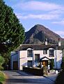
Mellbreak seen from the Kirkstile Inn, in Loweswater village

