Burnbank Fell facts for kids
Quick facts for kids Burnbank Fell |
|
|---|---|

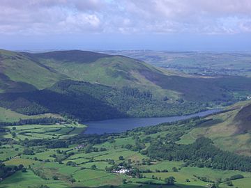
Seen across Loweswater from the fell of Whiteside, 8 km to the east.
|
|
| Highest point | |
| Elevation | 475 m (1,558 ft) |
| Prominence | c. 20 m |
| Parent peak | Blake Fell |
| Listing | Wainwright |
| Geography | |
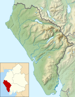
| Location | Cumbria, England |
| Parent range | Lake District, Western Fells |
| OS grid | NY110209 |
| Topo map | OS Landranger 89, 90, Explorer OL4 |
Burnbank Fell is a lovely, small hill located in the western part of England's famous Lake District. It's the most western hill in a group called the Loweswater Fells. These are low, grassy hills found just south of the beautiful Loweswater lake.
Burnbank Fell is mostly covered in grass. It has wide, gentle slopes and a broad ridge that connects it to a nearby hill called Blake Fell. You can climb this fell from a village called Lamplugh in the west. Another way to reach the top is from Waterend, which is right by the lake.
Contents
What is Burnbank Fell Like?
Burnbank Fell is part of the Western Fells in the Lake District. These fells form a big horseshoe shape around the long, wild valley of Ennerdale. Burnbank Fell and the other Loweswater Fells are at the very end of the northern side of this horseshoe.
The Loweswater Fells are often compared to the fingers on a hand. They spread out from the "palm," which is centered around Loweswater village. From west to east, these fells are Burnbank Fell, Blake Fell, Gavel Fell, Hen Comb, and Mellbreak. Mellbreak is sometimes called the "thumb" of this group.
Burnbank Fell marks the edge of the Lakeland Fells. Its base touches the boundary of the Lake District National Park. Beyond it lies the River Marrom valley and coastal towns. Just outside the park, you can see Mockerkin How, a small hill, and Mockerkin Tarn. This tarn is a natural lake known for its water lilies. It has fish like eels, pike, and perch. Local legends even say a sunken town is hidden there!
The northeastern sides of Burnbank Fell are quite steep. There are some rocky areas higher up that look over Loweswater. Lower down, you'll find Holme Wood. This pretty forest makes a lovely background when you look across the lake. Holme Beck flows through these trees. It forms the border between Burnbank Fell and Blake Fell. Deep within the woods, you can find Holme Force, which is a beautiful pair of waterfalls.
A ridge goes west from the summit to Owsen Fell. Owsen Fell is generally seen as part of Burnbank Fell. It slopes down to the village of Lamplugh. Its lower parts have forests of conifer trees. All the water from Owsen Fell and the western slopes flows into the River Marron. This river eventually joins the River Derwent.
What is Burnbank Fell Made Of?
The top of Burnbank Fell is made of a type of rock called Kirk Stile Formation. This rock is a mix of layered mudstone and siltstone. On the eastern slopes, you can see rocks from the Loweswater Formation. These are greywacke sandstone rocks, formed by underwater currents.
Old maps show that there were once abandoned mine tunnels above Wisenholme Beck. There was also some digging for materials near the summit. The famous fell-walker Wainwright also noted another old mine tunnel on the eastern slopes.
The Top of Burnbank Fell
The very top of Burnbank Fell is a round, grassy dome. You'll find an old fence post and a small pile of stones, called a cairn, marking the summit. The view of the Lake District from here is a bit blocked by Blake Fell. However, you can still see many of the Northern and North Western Fells.
Loweswater lake is hidden by the slope of the hill. But if you walk a few steps northeast, you can see Crummock Water lake. The view towards the coast is wide open. You can see the Isle of Man, the Solway Firth, and even Criffel in Scotland on a clear day!
How to Climb Burnbank Fell
If you start from Lamplugh, the clearest way up is via Owsen Fell. However, it's not always clear if you have the right to walk there.
Another popular route starts from Waterend, at the top of Loweswater. You begin by passing Hudson Place farm and entering Holme Wood. From there, several paths lead you to the summit. Two paths also go around the fell on this side. One is right by the lakeshore, and another "terrace" path is above the woods. Both offer pleasant walks. You can also use Fangs Brow farm to access the terrace path from the north.
 | James Van Der Zee |
 | Alma Thomas |
 | Ellis Wilson |
 | Margaret Taylor-Burroughs |


