Scar Crags facts for kids
Quick facts for kids Scar Crags |
|
|---|---|

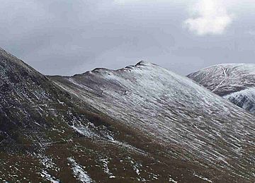
The northern slopes of Scar Crags from Stonycroft Gill.
|
|
| Highest point | |
| Elevation | 672 m (2,205 ft) |
| Prominence | 55 m (180 ft) |
| Parent peak | Crag Hill |
| Listing | Hewitt, Nuttall, Wainwright |
| Geography | |
| Location | Cumbria, England |
| Parent range | Lake District, North Western Fells |
| OS grid | NY208206 |
| Topo map | OS Landranger 89, 90, OS Explorer Outdoor Leisure 4 |
Scar Crags is a type of mountain, also called a fell, located in the north western part of the English Lake District. It's found in the county of Cumbria. This fell is part of a group of mountains known as the Coledale fells. It stands about seven kilometers (4.3 miles) southwest of Keswick and reaches a height of 672 meters (2,205 feet).
Contents
What Scar Crags Looks Like
Scar Crags is part of a long ridge that stretches east from a larger mountain called Eel Crag. This ridge also includes the nearby fells of Sail and Causey Pike before dropping down to the Newlands Valley.
The southern side of Scar Crags has steep, rocky cliffs that fall sharply to a stream called Rigg Beck. However, the northern slopes are much gentler and covered in grass. They lead down to another stream called Stoneycroft Gill.
How to Climb Scar Crags
Most people don't climb Scar Crags directly from the very bottom. There is an old mine road that starts from a place called Stair. This road goes up Stoneycroft Gill and ends at Sail Pass. From there, it's only a short walk to the top of Scar Crags.
It's more common for people to reach Scar Crags by walking along the ridge from other fells. You can approach it from the east, coming from Causey Pike. Or you can come from the west, after climbing Sail.
Scar Crags is a popular spot because it's part of a famous walking route called the Coledale Round. This is a long walk, about 17.5 kilometers (10.9 miles) in total. It starts and finishes in villages like Braithwaite or Stair in the Newlands valley. The Coledale Round includes climbing several other nearby fells, such as Grisedale Pike, Hopegill Head, Eel Crag, Sail, and Causey Pike. It involves climbing over 1,300 meters (4,265 feet) in total!
The Top of Scar Crags
The very top of Scar Crags is mostly grassy and can sometimes be a bit muddy. There's a small pile of stones, called a cairn, marking the summit. From the top, you get an amazing view looking down onto Rigg Beck. You also get a good, wide view of the surrounding Lake District area.
The Old Cobalt Mine
On the northern slopes of Scar Crags, below a spot called Long Crag, you can find the remains of a very old mine. This was the only cobalt mine ever found in the Lake District!
The Keswick Mining Company opened this mine in 1846. They spent a lot of money, about £7,000, trying to make it work. To get the ore (the rock with the valuable minerals) down the mountain, they built a road and a special sloped tramway. This carried the ore down to Stoneycroft in the Newlands valley.
Miners dug four tunnels, called adits, into the hillside. The longest of these tunnels was about 60 meters (197 feet) long. However, the mine was not successful. It turned out to be very difficult to get the cobalt out of the ore in the amounts they expected. Because of this, the mine eventually closed down.
 | Sharif Bey |
 | Hale Woodruff |
 | Richmond Barthé |
 | Purvis Young |


