Barrow (Lake District) facts for kids
Quick facts for kids Barrow |
|
|---|---|

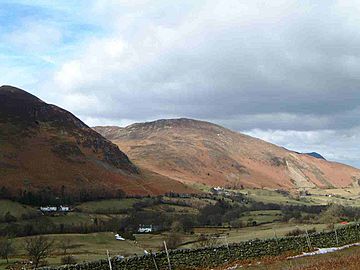
Barrow seen from the Newlands Valley; note
the light-coloured fans of mining spoil |
|
| Highest point | |
| Elevation | 455 m (1,493 ft) |
| Prominence | c. 60 m (197 ft) |
| Parent peak | Outerside |
| Listing | Wainwright |
| Geography | |
| Location | Cumbria, England |
| Parent range | Lake District, North Western Fells |
| OS grid | NY226218 |
| Topo map | OS Landranger 89, 90 OS Explorer 4 |
Barrow is a small mountain, also called a fell, in the beautiful Lake District in England. It is located in the county of Cumbria and stands 455 meters (1,494 feet) tall. You can find it in the Newlands Valley, about 4 kilometers (2.5 miles) southwest of Keswick.
Even though Barrow is not super tall, it offers amazing views all around. You can see the valleys of Keswick and Newlands from its top. The name Barrow comes from an old language, Anglo-Saxon, and means "a hill" or "long ridge."
What Barrow Looks Like
Barrow is shaped like a long, thin ridge. It climbs up towards the southwest from a village called Braithwaite. At its highest point, the summit, the ridge turns west. It then crosses a lower area known as Barrow Door. This area is shaped by the valley of Stonycroft Gill.
Beyond this lower area, you'll find other fells like Stile End and Outerside. To the northwest of Barrow is the valley of Coledale. A stream called Newlands Beck forms the eastern edge of Barrow.
How to Climb Barrow
Climbing Barrow is a fun, shorter hike. Most people start their climb from either the Newlands Valley or the village of Braithwaite. You can even combine this climb with a visit to the nearby, taller fell called Outerside.
If you start from the Newlands Valley, your journey begins at a small village called Stair. From there, you can follow an old mining road. This road goes up Stonycroft Gill to a height of about 350 meters (1,148 feet). Then, you turn east to reach the very top of Barrow.
If you prefer to start from Braithwaite, there are two main paths. One path follows the northern side of the fell's ridge. The other path goes up the valley of Barrow Gill.
Barrow's Rocks and History
Barrow is made up of layered mudstone and siltstone. These are common types of rock found in the Skiddaw group of mountains. There is also a band of greywacke sandstone along the eastern side of the fell.
Like many fells in the Newlands Valley, Barrow was once a very active mining area. People dug for lead here a long time ago. You can still see the huge piles of leftover rock and dirt from the mines. These spoil heaps are light in color and stand out clearly from a distance.
The Barrow mine first opened in the 1600s and finally closed in 1888. It's said that the spoil heaps are always moving slightly. If you listen closely, you might even hear a small rustling sound as the loose rock slides down the hill.
Another interesting feature on Barrow is a deep ditch called Barrow Gill. This large ravine is on the Braithwaite side of the fell. It seems much bigger than the small stream that flows through it.
Reaching the Summit
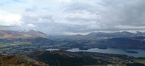
At the very top of Barrow, you'll find a small pile of stones, called a cairn, on a grassy area. The top is surrounded by heather plants. From the summit, you get amazing views of the other higher North Western Fells nearby. You can also see the Helvellyn range across Derwentwater lake. And you'll spot Skiddaw mountain standing tall above Keswick.
 | Frances Mary Albrier |
 | Whitney Young |
 | Muhammad Ali |


