Seatallan facts for kids
Quick facts for kids Seatallan |
|
|---|---|

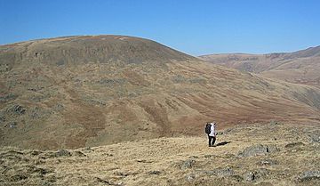
Seatallan seen from the neighbouring Middle Fell
|
|
| Highest point | |
| Elevation | 692 m (2,270 ft) |
| Prominence | 193 m (633 ft) |
| Parent peak | Pillar |
| Listing | Marilyn, Hewitt, Wainwright, Nuttall |
| Geography | |
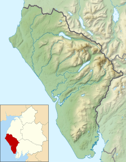
| Location | Cumbria, England |
| Parent range | Lake District, Western Fells |
| OS grid | NY139084 |
| Topo map | OS Landranger 89, Explorer OL6 |
Seatallan is a mountain located in the western part of England's beautiful Lake District. It's a rounded, grassy hill that covers a large area. Even though it looks gentle, it's special because it's known as a Marilyn. This means it stands out enough from other hills. It's connected to Haycock, a taller neighbour to the north, by a low dip in the land called a col. The name Seatallan probably comes from an old language called Cumbric. It means "Aleyn's high pasture" or grazing land.
Contents
Exploring Seatallan's Landscape
The Western Fells are a group of mountains in the Lake District. They form a triangle shape. The River Cocker is to the northeast and Wasdale is to the southeast. As you go west, the hills get smaller and lead to the coast. In the middle of these high lands are Great Gable and its nearby peaks. Two main ridges spread out from Ennerdale, a long, wild valley. Seatallan is part of the southern ridge of these western fells.
How Seatallan Connects to Other Peaks
The main ridge of mountains goes west from Great Gable. It separates the streams that flow into Ennerdale and Wasdale. Along this ridge, you'll find Kirk Fell, Pillar, Scoat Fell, Haycock, and Caw Fell. Haycock has a long ridge that goes south, and Seatallan is at the end of it.
Seatallan starts at a wide, grassy area called the Pots of Ashness. This area is south of Haycock. From here, you climb steeply up to the top. The very top of Seatallan looks like a cone that's been cut at an angle. It slopes down towards the south. This cone sits on a much bigger, flat area of high land. This flat area stretches about five miles to the southwest.
Rivers and Valleys Around Seatallan
The River Bleng forms the western edge of Seatallan. It starts on the slopes of Haycock and flows in a big loop to the southwest. Eventually, it joins the River Irt and flows into the sea at Ravenglass. The lower parts of the Bleng's path, near Gosforth, are used for farming. Higher up on the southwest side of Seatallan, there are forests of pine trees. These are found along the Bleng and above the Irt. The open, wild hillside begins about two miles southwest of the summit.
To the east of the Pots of Ashness is the Nether Beck valley. This river flows into Wastwater. Beyond it is Red Pike. Nether Beck turns away from Seatallan as it flows south. This is because of the rocky hill called Middle Fell. Middle Fell is a broad ridge that comes off the east side of Seatallan's summit. Middle Fell curves around to run next to Seatallan. The Greendale Gill valley separates the two. This stream starts at Greendale Tarn.
Greendale Tarn and Buckbarrow
Greendale Tarn is a small lake nestled into the steep side of Middle Fell. This tarn is about 30 feet deep. It sits in a long, narrow basin and is surrounded by huge rocks.
Seatallan's most striking feature is Buckbarrow. This is a 400-foot-high wall of cliffs on the southern edge. It looks down over lower Greendale and Wast Water. Buckbarrow is so important that Alfred Wainwright wrote a separate chapter about it in his book, The Western Fells. This means it's considered a Wainwright, even though it doesn't have its own high point. Above Buckbarrow are smaller tops called Glade How and Cat Bield. These lead to the large southwest shoulder of Seatallan. Seatallan also has smaller rocky areas above the upper Bleng (called Raven Crag) and Nether Beck (called Winscale How).
Understanding Seatallan's Rocks
Most of Seatallan is covered in thick layers of soil and rock pieces. But underneath, the main rock is a type of dacite lava called Seatallan Dacite. This rock contains small crystals of plagioclase. Above the Bleng river, there are large areas of diorite rock. Around Buckbarrow, you can find outcrops of andesite rock, which is part of the Birker Fell Formation. Smaller amounts of rhyolite and basalt rocks have also been found to the north.
Reaching Seatallan's Summit
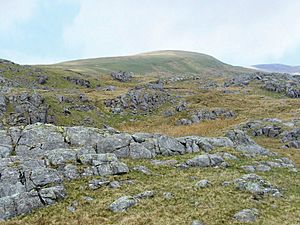
At the very top of Seatallan, there's a large mound of stones called a tumulus. Next to it is a pillar used by the Ordnance Survey for mapping. The top of the mountain is covered in grass. People believe the stone mound was built from rocks found on the north slope. The view from the top is partly blocked by the main range of the western fells. However, you can still see the high points of the Scafells and the Coniston Fells. If you walk northeast, you can get a good view of Wastwater.
Ways to Climb Seatallan
There are several ways to climb Seatallan. You can start from Harrow Head and climb indirectly by going over Buckbarrow. Another way is to go around Buckbarrow and reach Cat Bields from the southwest.
From Greendale, you can follow the Greendale Gill stream almost to the tarn. Then, you can turn off and climb the grassy slopes of Seatallan. If you prefer, you can use Middle Fell as a stepping stone to Seatallan from the same starting point. Finally, from Nether Beck Bridge, you can follow the route towards Haycock. Then, turn west near Lad Crag Beck to reach the summit.
 | Shirley Ann Jackson |
 | Garett Morgan |
 | J. Ernest Wilkins Jr. |
 | Elijah McCoy |


