
Crinkle Crags facts for kids
Quick facts for kids Crinkle Crags |
|
|---|---|

|
|
| Highest point | |
| Elevation | 859 m (2,818 ft) |
| Prominence | c. 138 m (453 ft) |
| Parent peak | Scafell Pike |
| Listing | Hewitt, Nuttall, Wainwright |
| Geography | |

Crinkle Crags
Location in Lake District

Crinkle Crags
Location in the Borough of Copeland

Crinkle Crags
Location in South Lakeland
|
|
| Location | Cumbria, England |
| Parent range | Lake District, Southern Fells |
| OS grid | NY248048 |
| Topo map | OS Landranger 89, 90, Explorer OL6 |
| Listed summits of Crinkle Crags | ||||
| Name | Grid ref | Height | Status | |
|---|---|---|---|---|
| Crinkle Crags South Top | NY248048 | 834 m (2,736 ft) | Hewitt, Nuttall | |
| Shelter Crags | NY249053 | 815 m (2,673 ft) | Hewitt, Nuttall | |
| Shelter Crags North Top | NY249057 | 755 m (2,542 ft) | Nuttall | |
| Little Stand | NY250034 | 740 m (2,482 ft) | Nuttall | |
| Great Knott | NY260043 | 696 m (2,283 ft) | Nuttall | |
Crinkle Crags is a famous fell (a type of mountain or hill) in the beautiful Lake District in Cumbria, England. It's part of two big groups of mountains. These mountains surround the valleys of Great Langdale and Upper Eskdale.
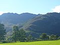
The name "Crinkle Crags" perfectly describes how the mountain looks. Its top ridge has five distinct bumps and dips, like a twisted or wrinkled line. These "crinkles" are easy to spot from the valley below. The word cringol in Old English means twisted or wrinkled.
Exploring Crinkle Crags
Crinkle Crags is known for its unique shape. It has five main bumps, often called "crinkles." These crinkles can be confusing because different guidebooks name them in different ways. For example, some start counting from the north, and others from the south.
The second crinkle, also known as Long Top, is actually the highest point of the mountain. Another crinkle is sometimes called Gunson Knott. Beyond the main crinkles to the north, you'll find more rocky areas called Shelter Crags.
Some lists of mountains, like the Hewitts and Nuttalls, help climbers keep track of peaks. These lists include the main summit and two tops on Shelter Crags. They also include the southernmost crinkle, called Crinkle Crags South Top.
The Mountain's Layout
Crinkle Crags stretches south from its taller neighbor, Bowfell. Between them is a dip in the land called Three Tarns. This spot is named for the small pools of water found there. Depending on how much rain has fallen, you might see anywhere from two to five pools!
South of the main summit, the ridge goes down towards the Duddon Valley. Along this path are other smaller peaks like Stonesty Pike and Little Stand.
Two other ridges branch off from Crinkle Crags. One goes west, across a wet area called Moasdale, towards Hard Knott. The other goes east towards Cold Pike. Between Cold Pike and Crinkle Crags is another peak called Great Knott.
Climbing Crinkle Crags
The famous guidebook writer, Alfred Wainwright, loved Crinkle Crags. He wrote that it is "much too good to be missed." He thought it was a climb that everyone should try.
There are several ways to reach the top. Many people start their climb from Great Langdale. They often combine it with other nearby mountains like Bowfell or Cold Pike. This creates a long, high-level walk that covers many peaks.
You can also climb Crinkle Crags from Eskdale. This route is very scenic but it's a long trip, about 15 kilometers (9 miles) round trip. If you want a shorter climb, you can drive your car to the top of the Wrynose Pass road.
At the Summit
Walking along the top ridge of Crinkle Crags is an exciting adventure. You'll go up and down over the different crinkles. There's a tricky spot called the "Bad Step." It's a steep drop that can surprise climbers coming from the north. But don't worry, you can easily go around it if you prefer.
The views from the summit are amazing! You can see wide views of Great Langdale, Eskdale, and Dunnerdale. You can also spot the mouths of the Duddon and Esk rivers as they flow into the Irish Sea.
You'll get a fantastic view of England's highest mountain, Scafell Pike. It's only about four kilometers (2½ miles) away to the northwest. From Shelter Crags, you can see all around you.
See a panorama from the summit
Gallery
-
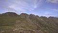
The five Crinkles as seen from Great Knott
-
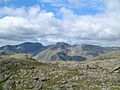
The Sca Fell mountain group from the top of Crinkle Crags
-
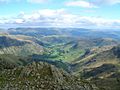
Great Langdale valley from the summit of Crinkle Crags
-
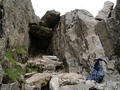
The famous 'Bad Step' on the ridge
-
The Crinkles (left) looking up The Band


