Cold Pike facts for kids
Quick facts for kids Cold Pike |
|
|---|---|

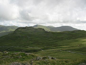
Cold Pike from Great Knott
|
|
| Highest point | |
| Elevation | 701 m (2,300 ft) |
| Prominence | c. 46 m |
| Parent peak | Crinkle Crags |
| Listing | Hewitt, Nuttall, Wainwright |
| Geography | |
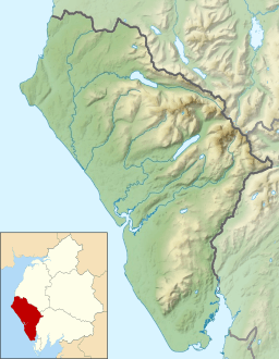
| Location | Cumbria, England |
| Parent range | Lake District, Southern Fells |
| OS grid | NY262035 |
| Topo map | OS Landranger 90, Explorer OL6 |
Cold Pike is a mountain, also known as a fell, located in the beautiful Lake District in England. It's like a smaller helper mountain to the bigger Crinkle Crags. Cold Pike stands tall above the upper part of the Duddon Valley. It's a popular spot for hikers and offers amazing views of the surrounding area.
Contents
Where is Cold Pike?
Cold Pike is part of a group of mountains called the Southern Fells in the Lake District. Imagine a giant hand with three fingers pointing south; Cold Pike is at the end of one of these "fingers" or ridges. These ridges stretch out from Crinkle Crags.
The mountain's ridge starts with rocky bumps and small lakes, called tarns, near the Fifth Crinkle. It then goes down to a wide, grassy dip before rising up to the top of Cold Pike. To the north of this dip is Great Knott. Most guidebooks see Great Knott as part of Crinkle Crags, not Cold Pike.
Wrynose Pass and Ancient Roads
Beyond the top of Cold Pike, the ridge continues for about half a mile southeast. It then drops steeply over rocky cliffs called Wrynose Breast. Wrynose Breast is above the Duddon River, which is just starting its journey, and the Wrynose Pass road. This road is the only way for cars to get between the central Lake District and the Duddon Valley.
The Wrynose Pass, along with Hardknott Pass to the west, follows the path of an old Roman road. This ancient road once connected Ambleside to the port of Ravenglass.
Nearby Features
To the west of Cold Pike, you'll find Gaitscale Beck, a stream that separates Cold Pike from another mountain called Little Stand. To the east, across a wide, low mountain path called a col, is Pike of Blisco. This mountain looks like a cone and is firmly rooted in Great Langdale. The Duddon River starts flowing south from this col, curving west around the base of Wrynose Breast.
To the north is Red Tarn, a long, clear lake with a stony bottom. People say there are trout in its shallow waters. Red Tarn is a key spot for walkers because a wide path from Wrynose Pass to Stool End runs right beside it. Another path branches off from here, leading towards Crinkle Crags.
What is Cold Pike Made Of?
The very top of Cold Pike is made of a type of hardened lava called dacite. Below that, to the south, you can find layers of volcanic rock and sandstone.
There's also a bit of history here! The main path near Red Tarn was originally built for the Red Crag Mine. This mine had several pits and test holes where people looked for iron. It was active from 1860 to 1875, but it never made much money.
The Top of Cold Pike
The top of Cold Pike is a wide, flat area with three separate high points. All three of these are listed as Nuttalls, which are mountains over 2,000 feet high. The two lower points don't have names on maps, but people usually call them Cold Pike West Top and Cold Pike Far West Top.
The true summit (the highest point) is one of three rocky outcrops, similar to how Crinkle Crags has several peaks. Each of these high points has a cairn, which is a pile of stones built by hikers. The highest cairn is a really good one! From the top, you get amazing views of Crinkle Crags, the Langdale Pikes, and the northern part of the Coniston Fells across Wrynose Bottom. On a clear day, you can even see the distant Pennines mountains above Windermere and Morecambe Bay over the Duddon Valley.
How to Climb Cold Pike
It's quite easy to reach Cold Pike by walking from Red Tarn. You can start your walk from the car park at the top of Wrynose Pass. You can also climb it from Great Langdale, though this route is a bit harder.
If you're a more adventurous walker starting from the south, you might begin your journey from Little Langdale or Wrynose Bottom. From there, you would first walk up Wrynose Pass. You can also take a direct route from Wrynose Bottom, but there isn't a clear path, and you'll need to walk around the left side of the cliffs. Be aware that you might have to cross the Duddon River at the start of this route. Many hikers see Cold Pike as a great side trip when they are on their way to climb Crinkle Crags.
 | Jackie Robinson |
 | Jack Johnson |
 | Althea Gibson |
 | Arthur Ashe |
 | Muhammad Ali |


