
Little Langdale facts for kids
Quick facts for kids Little Langdale |
|
|---|---|
.jpg) Little Langdale viewed from Wrynose Pass |
|

Little Langdale
|
|
| OS grid reference | NY315033 |
| Civil parish |
|
| District |
|
| Shire county | |
| Region | |
| Country | England |
| Sovereign state | United Kingdom |
| Postcode district | LA22 |
| Dialling code | 015394 |
| EU Parliament | North West England |
| UK Parliament |
|
Little Langdale is a beautiful valley in the Lake District, England. It's home to a small lake called Little Langdale Tarn and a tiny village also named Little Langdale. Another lake, Blea Tarn, sits in a special kind of valley called a hanging valley. This means it's a valley that ends high up on a hillside, above a main valley.
Little Langdale is surrounded by impressive mountains. To the south and southwest are Wetherlam and Swirl How. To the north and northwest, you'll find Lingmoor Fell and Pike of Blisco. The valley gently slopes down to meet the larger Great Langdale valley, near Elter Water.
Contents
What is Little Langdale Like?

The name Langdale used to be Langdene. This means 'far away wooded valley'. It got this name because it was a long way along an old flint trading route.
Long ago, Little Langdale was a busy crossroads. It was a meeting point for packhorse routes. These were paths where horses carried goods to places like Ravenglass, Whitehaven, Keswick, Penrith, Carlisle, Ambleside, Hawkshead, and Coniston.
One important part of these old routes is Slater's Bridge. This bridge crosses the River Brathay. It was built in the 16th century using slate. It has three parts supported by a large boulder in the middle of the river. Today, paved roads lead from Little Langdale. You can go west over Wrynose Pass and Hardknott towards Eskdale. You can also go northwest past Blea Tarn to Great Langdale. Other roads go northeast to Elterwater and east to the road between Skelwith Bridge and Coniston.
A cycling path, National Cycle Network's Regional Route 37, also goes through the valley. This route connects Ambleside and Ulverston.

The National Trust owns many farms and areas of land in the valley. Many of these farms were built in the 1600s. Besides farms and houses, the village has an inn. The Three Shires Inn was built in 1872. It's named after the Three Shires Stone, which is about 3 kilometers away. The Inn is also where the famous Three Shires Fell Race starts.
Little Langdale gets a lot of rain, about 2408 millimeters each year. This is more than the average for the Lake District, which is already a very wet place in the UK! Today, the land in Little Langdale is mostly used for raising sheep and cattle. In the past, some of the land was also used for growing crops.
The valley was also a filming location for the 2012 movie Snow White and the Huntsman.
Exploring the Mines and Quarries
Little Langdale has a long history of mining and quarrying. For hundreds of years, people dug for copper and slate here. Today, there isn't much mining happening. Some of the old workings include big slate quarries at Hodge Close and Tilberthwaite. There were also mines on the southern slopes of Wetherlam.
An old mine at Hawk Rigg might be from the time of Queen Elizabeth I. In 1709, people reported that iron ore was mined in the area. Slate mining became very popular in the Victorian era. This was because new tools like compressed air drills made it easier to blast holes in the rock. Slate mining continued until high-quality bricks became common for building.
The rocks in the valley are mainly Borrowdale tuff and rhyolite. There are also layers of andesite sills and areas of slate, especially to the south.
Cathedral Quarries: A Giant Cave

Cathedral Quarries (Grid NY308028) are old, connected quarries for green slate. They are located above the valley in Atkinson Coppice. The National Trust now looks after this quarry site. Visitors can explore it. It has many rooms and tunnels, including one that is 400 feet (122 meters) long.
The most amazing part is 'The Cathedral'. This is a huge main room, 40 feet (12 meters) high. It's lit by two windows, and a giant rock pillar holds up the roof. Some smaller rooms in the quarry are closed for safety or have already fallen in.
The quarry is also a popular spot for rock climbing. It has at least 25 named climbing routes. These routes are considered very difficult (graded Extreme) and are 30–40 meters long. The piles of waste rock from these mines now have silver birch and larch trees growing on them.
Greenburn Mine: A Copper Mine
.jpg)
Greenburn Mine, also known as New Coniston Mine, is near Greenburn Beck. It's thought to be the best-preserved copper mine in the Lake District. Most of the mining happened in the mid-1800s, but it might have started as early as the late 1600s. The mine closed in 1865 but opened again later, possibly until 1940. The deepest parts of the mine went down 700 feet (213 meters) below the ground.
The mine had a large Engine Shaft with equipment for lifting and pumping. This was powered by a huge 9.8-meter overshot water wheel. There were also other shafts, tunnels (called adits), and a crushing mill. This mill was powered by a second water wheel. The mine also had an inclined tramway and tanks for processing the copper. You can still see the remains of buildings like a smithy (where metal was worked), an office, and a place for miners to change.
Miners dug for at least five copper veins here. These were called the Sump, Pave York, Low Gill, and Gossan Veins. In 1906, the Greenburn and Tilberthwaite Syndicate ran the mine. Later, in 1912, the Langdale Silver, Lead and Copper Company took over. There was a reservoir built in the 1800s that was about 1.6 hectares in size. But a big storm in 1979-80 caused the dam to break. This lowered its height from about 7.5 meters to 6 meters today.
Discovering Blea Tarn
| Blea Tarn | |
|---|---|

Blea Tarn with Rakerigg, Blake Rigg and Pike of Blisco from Lingmoor Fell
|
|

Blea Tarn
Location in Cumbria
|
|
| Location | Lake District |
| Coordinates | 54°25′49″N 3°5′28″W / 54.43028°N 3.09111°W |
| Type | Tarn |
| Primary outflows | Bleamoss Beck |
| Catchment area | 1.16 km2 (0.45 sq mi) |
| Surface area | 3.48 ha (8.6 acres) |
| Average depth | 7 m (23 ft) |
| Max. depth | 8 m (26 ft) |
| Surface elevation | 230 m (750 ft) / < 190 m (620 ft) (OS map) |
Blea Tarn is a small lake found in a hanging valley between Great Langdale and Little Langdale. The lake was formed by glaciers moving over the mountain pass from Great Langdale. As the glacier got smaller, it left behind piles of rock and dirt, creating the tarn.
There's a car park near the tarn for visitors. An easy-to-use path goes all the way around the lake. The western side of the tarn is covered in trees, and you can also find rhododendrons there. The other sides are grassy fields. In 1969, Blea Tarn was described as having low nutrients and being acidic. It had not been harmed by pollution from fertilizers. You can find Brown trout, perch, and pike fish in the tarn.
Blea Tarn was named a SSSI in 1989. This is because it's very important for studying the environment from ancient times, specifically the Devensian and Flandrian periods. Studies of pollen from Blea Tarn show that people were collecting elm branches for animal fodder as far back as 3300 BC. Forests were also cleared between 3000 and 2000 BC. This matches the time when the Great Langdale axe factory was active.
Nearby, the Side Pike SSSI was named in 1977. It's one of the few places in the British Isles where you can see rocks formed by volcanoes on land. The ignimbrite and tuff rocks there are part of the Borrowdale Volcanic Group.
The Blea Tarn Farmhouse
The farmhouse near Blea Tarn was built in the 1600s, with more added in the 1800s. It's now a Grade II listed building, which means it's historically important. It belongs to the National Trust and is rented to a local family. It's no longer a working farm.
Both the farmhouse and the tarn are mentioned in a poem by William Wordsworth called 'The Solitary'. He described it as a "quiet treeless nook, with two green fields, A liquid pool that glittered in the sun, and one bare Dwelling."
"...to the south
Was one small opening, where a heath-clad ridge
Supplied a boundary less abrupt and close;
A quiet treeless nook, with two green fields,
A liquid pool that glittered in the sun,
and one bare Dwelling; one Abode, no more !
It seemed the home of poverty and toil
Though not of want: the little fields, made green
By husbandry of many thrifty years,
Paid cheerful tribute to the moorland House. ..."—William Wordsworth, 1814
Little Langdale Tarn: A Natural Gem
| Little Langdale Tarn | |
|---|---|
 |
|
|
Little Langdale Tarn
Location in Cumbria
|
|
| Location | NY 308032 / NY 309 033 Lake District |
| Coordinates | 54°25′11″N 3°3′58″W / 54.41972°N 3.06611°W |
| Type | infilled glacial valley bottom |
| Primary inflows | River Brathay & Bleamoss Beck, Greenburn Beck |
| Primary outflows | River Brathay |
| Catchment area | 12.0 km2 (4.6 sq mi) |
| Max. length | 375 m (1,230 ft) |
| Max. width | 275 m (902 ft) |
| Surface area | 0.063 km2 (0.024 sq mi), 0.073 km2 (0.028 sq mi) |
| Average depth | 2.7 m (8 ft 10 in) |
| Max. depth | 9.5 m (31 ft) |
| Water volume | 2×10⁶ m3 (1,600 acre⋅ft) (see note) |
| Residence time | 2 days 3.3 days |
| Surface elevation | 103 m (338 ft) |

Little Langdale Tarn is a natural lake in a marshy part of the valley. The National Trust manages the area around the tarn, and it's not open for public access. It's a typical lake for Southern Cumbria, meaning it has a medium amount of nutrients. Even though the tarn itself isn't very high up, the land around it reaches an average height of 520 meters.
The tarn and about 30 hectares of its surrounding areas were named a SSSI in 1965. The different types of habitats next to the tarn include swamps, fens, grassy marshes, hay meadows, and wet woodlands. Studies of tiny algae called diatoms in 1984 and 1999 showed that the lake's pH (how acidic or basic it is) had increased. However, older diatom studies from the lake's bottom suggest the pH actually decreased from 6.3 to 5.8 over a longer time.
Little Langdale Tarn was much bigger at the end of the last ice age. The area that used to be part of the lake is now filled with sediment, creating the flat farmland next to the current lake. The surrounding area is used for sheep farming. It has rough grassland and sphagnum bog in the valley bottom and on the hillsides. Studies of the lake's bottom show a top layer of brown organic material. Below that is a grey layer rich in copper from the mining activities at Greenburn. The amount of sediment building up in the lake has increased over time. This is mainly due to water flowing from peat pipes and sheep grazing near Wrynose Beck, a stream that flows into the River Brathay.
Animals and Plants of Little Langdale
The wild animals in Little Langdale are similar to those in other nearby valleys. You might see:
Birds you might spot include:
You might also see slowworms. Rarely, you might spot an adder (a type of snake), an otter, or a red squirrel. Sadly, Pine martens, which used to be rare, are no longer seen in the valley. The shore of Little Langdale Tarn is home to great crested grebes and the dark green fritillary butterfly.
Twenty acres of fields in the center of Little Langdale village were named an SSSI in 1989. This is because they are some of only four remaining meadows of SSSI quality in South Cumbria. The habitat changes from floodplain near the River Brathay to higher, drier hay meadows. Both areas are home to many different kinds of herbs, grasses, and flowers.
Some grasses found here include:
- sweet vernal-grass
- wood-crane's-bill
- common bent
- crested dog's tail
- red fescue
- meadow fescue
- Yorkshire-fog
- smooth meadow-grass
- rough meadow-grass
- cock's-foot
- soft brome
- perennial rye-grass
Perhaps the rarest flower found in these meadows is the beautiful globe-flower.
A Look at Little Langdale's History
The valley has been lived in for a very long time. A Bronze Age axe was found on Low Fell in 1961. Remains of an Iron Age hillfort have been found at Castle Howe. This includes a hut circle and ditches cut into the rock. However, more recent research suggests it might not have been a hillfort.
The Viking Age in Little Langdale
The Ting Mound, also called the Thing Moot, is located at Fellfoot Farm. It's a specially shaped mound near an old Roman road and other travel routes. This mound was used as an outdoor meeting place for local government. It's believed that Viking settlers built it, possibly starting in the 900s. However, archaeologists haven't been able to date it exactly.
The mound looks very similar to the Tynwald Mount on the Isle of Man. Its appearance around the late 1800s was described by H.S. Cowper and painted by W. G. Collingwood.
Medieval Times and Beyond
You can still see the remains of medieval settlements. These include stone-walled houses at Seven Intakes. There are also remains of a medieval farmstead with a kiln, possibly for drying corn, nearby at Long Intakes. Other possible medieval remains have been found in the valley. Almost all the stone from these old buildings has been reused to build dry stone walls.
Many farmhouses in the area were built in the 1600s. People say that a chapel once stood near the Bield and Tarn at Chapel Mire.
Famous People Who Lived Here

The Bield, a 17th-century farmhouse, was home to the Brazilian sculptress Josefina de Vasconcellos for much of her life. Margaret Cropper (1886-1980), a very talented Cumbrian poet, lived at Bridge End.
Little Langdale was also home to a famous 19th-century smuggler named Lanty Slee. Slee had many secret places (called stills) for making homemade whisky. These were hidden in caves and quarries around the area, including one in Moss Rigg quarry. He would then transport the whisky over Wrynose and Hardknott to Ravenglass. In 1840, Slee built Greenbank Farm in the valley.
Images for kids
-
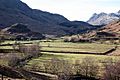
The valley with Castle Howe on the left and the Langdale Pikes on the horizon to the right.
-
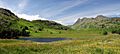
Blea Tarn and the surrounding meadows in July, with the Langdale Pikes in the background.
-
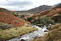
Bleamoss Beck below Blea Tarn.


