
Swirl How facts for kids
Quick facts for kids Swirl How |
|
|---|---|

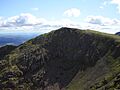
Swirl How from Great Carrs
|
|
| Highest point | |
| Elevation | 802.42 m (2,632.6 ft) |
| Prominence | c. 112 m (disputed) |
| Listing | Wainwright, Hewitt, Nuttall |
| Geography | |

Swirl How
Location in Lake District
|
|
| Location | Cumbria, England (traditionally Lancashire) |
| Parent range | Lake District, Southern Fells |
| OS grid | NY273006 |
| Topo map | OS Landranger 97, Explorer OL6 |
Swirl How is a mountain, also called a fell, in the English Lake District. It stands between the areas of Coniston and the Duddon Valley. This location is in the southern part of the Lake District.
Swirl How is one of the highest points in the historic region of Lancashire. It is often compared to the Old Man of Coniston for this title. Since 1974, the area has been managed by Cumbria County Council.
The mountains around Coniston, known as the Coniston Fells, separate Coniston Water from the Duddon Valley. This mountain range starts at Wrynose Pass and stretches south for about 10 miles.
Alfred Wainwright, a famous guidebook writer, included Swirl How in his book Pictorial Guide to the Lakeland Fells. He considered it one of the 214 main mountains of the Lake District.
Contents
How Tall is Swirl How?
On May 24, 2018, experts measured Swirl How. They found its height to be 802.42 meters (about 2,632 feet) tall.
During the same survey, they also measured the nearby Old Man of Coniston. Its natural ground was also 802.42 meters high. However, the top of its man-made stone platform was 803.53 meters.
The surveyors said that the Old Man of Coniston likely has higher ground hidden under its platform. Because of this, it usually keeps its status as the highest point in the Furness Fells.
As of 2020, maps from the Ordnance Survey show the Old Man of Coniston at 803 meters. Swirl How is shown at 802 meters.
Whichever mountain is taller, it is the highest point in the historic County Palatine of Lancashire. It is also the highest point in the Furness Fells.
The Shape of Swirl How
Swirl How has ridges that spread out in four directions. These ridges lead to other mountains. Because of this, the mountain also feeds four different valleys.
To the north, a ridge goes towards Great Carrs. This ridge is called Top of Broad Slack. Broad Slack is a very steep grassy slope.
On the way to Great Carrs, you will find a memorial. This spot marks where a World War II plane crashed. It has parts of a Royal Canadian Air Force bomber.
You can see the plane's landing gear, a wooden cross, and a stone pile. Most of the wreckage was moved to make it less visible. An engine from the plane is now at the Ruskin Museum in Coniston.
The main ridge continues south, going down to a dip called Levers Hawse. From there, it rises again to Brim Fell. Beyond Brim Fell are Dow Crag and the Old Man of Coniston.
To the west of Levers Hawse is Tarn Head Beck valley. This stream feeds Seathwaite Tarn, a reservoir. This tarn was made bigger in the early 1900s to provide drinking water.
To the east of Levers Hawse is Levers Water. This smaller lake was also made bigger by a dam. It used to supply water to the Coniston Copper Mines. Now, it provides drinking water for Coniston village.
The eastern side of Swirl How goes down a stony slope called Prison Band. This leads to a dip at Swirl Hawse. From here, the path goes up to the top of Wetherlam.
What is Swirl How Made Of?
The top of Swirl How is made of volcanic rocks. These include types of rock called rhyolitic tuff and lapilli-tuff. There are also layers of andesitic lapilli tuff.
The Summit View
The very top of Swirl How has a nice stone pile, called a cairn. It is built near the edge of the Greenburn valley.
From the summit, you can see many other mountains to the north. In other directions, you might see the Isle of Man, Morecambe Bay, and the Pennines mountain range.
How to Climb Swirl How
You can climb Swirl How directly from the south via Levers Hawse. You can also climb from the east via Swirl Hawse. Both of these starting points can be reached from Coniston. Swirl Hawse can also be reached from Little Langdale.
Many hikers reach Swirl How by climbing one of the nearby mountains first. All four ridges leading to Swirl How have good paths.
What Does the Name Mean?
The meaning of the name Swirl How is not fully clear. The word svirle in a Norwegian dialect means to swirl or whirl. This suggests it might come from Old Norse.
The word How is thought to come from the Old Norse word haugr. This word means hill or mound.
Images for kids
-
Swirl How from Great Carrs
