Levers Water facts for kids
Quick facts for kids Levers Water |
|
|---|---|
 |
|
| Location | Lake District |
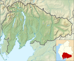
| Coordinates | 54°23′02″N 3°06′40″W / 54.384°N 3.111°W |
| Primary inflows | Swirl Hawse Beck, Cove Beck |
| Primary outflows | Levers Water Beck |
| Basin countries | United Kingdom |
| Surface area | 14 hectares (35 acres) |
| Average depth | 7.9 m (26 ft) |
| Water volume | 1,071,870 m3 (37,853,000 cu ft) |
| Surface elevation | 413 metres (1,355 ft) |
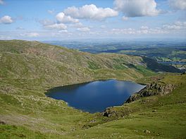
Levers Water is a beautiful, small lake nestled high up in the Lake District in England. It sits at the top of the Coppermines Valley, just above the village of Coniston. Imagine a peaceful spot surrounded by mountains! To its southwest, you'll see Raven Tor, which is part of Brim Fell. To the northwest are Little How Crags and Great How Crags, leading up to Swirl How.
Levers Water: A Mountain Lake
Levers Water is a type of lake often called a "tarn." A tarn is a mountain lake or pond formed in a hollow created by a glacier. This particular tarn was made bigger a long time ago.
How Levers Water Was Enlarged
In 1717, a special wall called a dam was built at Levers Water. This dam helped to make the existing tarn much larger. The main reason for building it was to collect more water. This water was then used for the mines in the valley below and also for the people living in Coniston village.
Exploring the Area Around Levers Water
Levers Water is a great place for hiking and exploring. There are public paths that let you discover the stunning mountain scenery.
One path on the northeast side connects the Coppermines Valley to a place called Swirl Hawse. Another path, to the southwest, goes up Gill Cove. This path leads to Levers Hawse, which is on the main ridge of the Coniston Fells. These paths offer amazing views and a chance to experience the wild beauty of the Lake District.
 | Dorothy Vaughan |
 | Charles Henry Turner |
 | Hildrus Poindexter |
 | Henry Cecil McBay |


