Wetherlam facts for kids
Quick facts for kids Wetherlam |
|
|---|---|

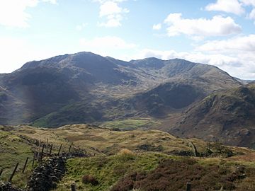
Wetherlam on the left, seen from Lingmoor Fell
|
|
| Highest point | |
| Elevation | 763 m (2502 ft) |
| Prominence | c. 145 m |
| Parent peak | Coniston Old Man |
| Listing | Wainwright, Hewitt, Nuttall |
| Geography | |
| Location | Cumbria, England |
| Parent range | Lake District, Southern Fells |
| OS grid | NY288011 |
| Topo map | OS Landranger 89, 90, Explorer OL6 |
| Listed summits of Wetherlam | ||||
| Name | Grid ref | Height | Status | |
|---|---|---|---|---|
| Black Sails | NY282007 | 745 m (2,444 ft) | Hewitt, Nuttall | |
Wetherlam (763 m) is a mountain located in the beautiful Lake District in England. It's the most northern mountain in the Coniston Fells range. This range of mountains is found to the north-west of the village of Coniston. The north-east side of Wetherlam slopes down towards Little Langdale.
Contents
What Does Wetherlam Look Like?
Wetherlam is a bit separate from the main line of the Coniston Fells. It connects to them through a long ridge (a line of hills) that comes from Swirl How. Along this ridge, you'll find a smaller peak called Black Sails. People usually think of Black Sails as part of Wetherlam.
Valleys and Water
From Swirl How, the ridge drops down steeply before rising again to Black Sails. South of Black Sails, there's a valley called Swirl Hawse Beck. This valley holds Levers Water, a mountain lake. This lake was made deeper by a dam a long time ago. It used to provide water for the Coniston Copper Mines. Today, Levers Water provides clean drinking water for Coniston and other nearby villages.
The main ridge continues east from Black Sails to the top of Wetherlam. Another ridge, called Lad Stones, goes south from Wetherlam's summit. Between these two ridges is a valley called Red Dell.
Wetherlam's Edges
Wetherlam also has a steep ridge that goes north-east, known as Wetherlam Edge. This leads to a pretty high area between Tilberthwaite and Little Langdale. This area has many rocky bumps. To the south-east of Wetherlam, you'll find another high area called Yewdale Fells.
North of Wetherlam is the Greenburn Valley. This valley is quite marshy and its water flows into the River Brathay. Greenburn also has a tarn, which was once a reservoir. It was dammed in the early 1700s to supply water to the Greenburn Mine. Now, the dam is broken, leaving a collection of small pools and wet areas.
The Top of Wetherlam
The very top of Wetherlam is a gentle, rounded shape with a pile of stones, called a cairn, marking the highest point. From here, you can see amazing views! You can see many of the other mountains in the Southern, Central, and Eastern Fells of the Lake District. The view of Little Langdale is especially beautiful.
Wetherlam's Mining History
In the past, people dug a lot on Wetherlam to find valuable minerals. The sides of the mountain are covered with old, unused copper mines and slate quarries. This makes Wetherlam one of the most industrialised (meaning it had a lot of industry) fells in the Lake District. However, the famous fell walker Alfred Wainwright said that these workings are small and don't really spoil the mountain's natural beauty.
Copper Mines
Most of the copper mining happened south of Wetherlam, in what is now called Coppermines Valley. Many shafts (deep holes) were dug in Red Dell and on the ridges around it. There were even mines under Levers Water! These mines were busiest in the 1850s and closed in 1915. People tried to reopen them in 1954, but too much had collapsed. The main thing they found was Copper Pyrite, but they also got iron, lead, nickel, and cobalt.
East of the mountain was Tilberthwaite Mine, which also dug for copper. These operations stopped in 1942. The mines in Greenburn, which used water from the reservoir there, were also known as New Coniston Mine. Copper was mined here from 1845 until most of the mine was closed in 1865. The shafts went down 700 feet underground!
Slate Quarries
Besides copper, there were also big slate quarries at Tilberthwaite. More slate was dug on the Yewdale Fells and the Lad Stones ridge. Slate is a type of rock often used for roofs and floors.
How to Climb Wetherlam
There are three main places where you can start your climb up Wetherlam:
- The village of Coniston to the south.
- The valley of Tilberthwaite to the east.
- The valley of Little Langdale to the north-east.
Routes from Coniston
From Coniston, you can follow a path and a rough road into the Coppermines Valley. This area is famous for its old mines and is also where people start to climb the Old Man of Coniston. To reach Wetherlam's summit from Coppermines, you can either go up the south ridge, called Lad Stones, or through the Red Dell valley.
Routes from Little Langdale or Tilberthwaite
If you start from Little Langdale or Tilberthwaite, you can take different paths to Birk Fell Hawse. This is a small pass to the north-east of the summit. From there, it's a steep climb up the Wetherlam Edge ridge to reach the top.
The Coniston Round
Many hikers climb Wetherlam as part of a longer walk called the "Coniston Round." This walk goes around the edge of the Coppermines Valley and includes other mountains like Swirl How, Brim Fell, and the Old Man of Coniston. Sometimes, people also add Dow Crag to this challenging hike.
 | Emma Amos |
 | Edward Mitchell Bannister |
 | Larry D. Alexander |
 | Ernie Barnes |

