Black Fell (Lake District) facts for kids
Quick facts for kids Black Fell |
|
|---|---|

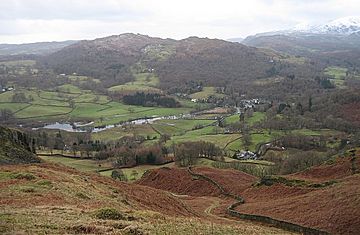
Black Fell from Loughrigg Fell
|
|
| Highest point | |
| Elevation | 323 m (1,060 ft) |
| Prominence | 126 m (413 ft) |
| Parent peak | Top o'Selside |
| Listing | Wainwright |
| Geography | |
| Location | Cumbria, England |
| Parent range | Lake District, Southern Fells |
| OS grid | NY341016 |
| Topo map | OS Landranger 89,90, Explorer OL7 |
Black Fell is a hill, also known as a 'fell', located in the beautiful Lake District in England. It stands north of a famous spot called Tarn Hows, between the towns of Coniston and Hawkshead. Even though it's not the tallest mountain, it offers amazing views and is a popular place for walks.
Contents
Exploring Black Fell's Landscape
Black Fell is the highest point in a hilly area. This area is surrounded by famous places like Windermere, Great Langdale, and Coniston. The fell itself is about one mile wide and two miles long. It's mostly covered in grass, with many small rocks sticking out.
Even though Black Fell isn't very tall, a famous guidebook writer named Alfred Wainwright gave it its own chapter. He did this because it offers such excellent views. He thought of Black Fell as the edge of the main Lake District fells.
How Black Fell Connects to Other Hills
Black Fell doesn't have obvious ridges connecting it to higher mountains. But it's actually in a key spot in this part of the Lake District. To the west, over a place called Oxen Fell High Cross, you can find Holme Fell. From there, you can reach Wetherlam and the Furness Fells.
To the southeast, a wide highland area stretches out. It runs between Windermere and Esthwaite Water. Finally, to the south, there's a seven-mile-long ridge. This ridge is part of Grizedale Forest and includes Carron Crag.
Waterways and Woodlands Around Black Fell
The northern edge of Black Fell is formed by Elter Water and the River Brathay. Near the village of Skelwith Bridge, you'll see the trees of Brow Coppice. To the east, the land gently slopes down for about a mile. This area has many tree plantations and leads to the top of Windermere.
You'll find many small lakes, called tarns, in this landscape. Most of them were created by people. The biggest ones are Blelham Tarn and some pools near the Drunken Duck Inn. On the western side of Black Fell, there's the A593 road. This road goes from Coniston to Ambleside and crosses a small pass called Oxen Fell.
Tarn Hows: A Popular Spot Nearby
South of Black Fell is Tarn Hows. This is a very beautiful area that was designed by James Marshall in the 1860s. It's one of the most popular places to visit in the Lake District. The mix of water, rocks, and different types of trees makes it very special.
The National Trust now owns Tarn Hows. So many cars visit that a one-way road system was started way back in the 1960s. A dam at the southwest corner helps maintain Tarn Hows. A wide, flat path goes all the way around the tarn, making it easy for everyone to enjoy. Most visitors stay on this path and don't explore the slopes of Black Fell. Many people don't even know the name of the hill that makes such a great background for their photos!
Who Owns Black Fell?
The entire fell used to belong to the Marshall family. Later, it was passed to a Mrs. Heelis, who is better known as the famous author Beatrix Potter. She then gave it to the National Trust. This means the fell is now protected forever for everyone in the country to enjoy.
Features of the Fell Top
While the lower parts of Black Fell have trees, the very top is open. The highest point is called Black Crag on maps. There are also other smaller tops like Great Cobble and Stephen How to the north. To the south, you'll find Arnside and Tover Intakes.
On the southern side of the fell, there's a wooded area called Iron Keld Plantation. The main path to the summit goes through this plantation. Some parts of the fell are steeper, especially at Pull Scar on the eastern side.
What Black Fell is Made Of
Black Fell is mostly made of a type of rock called dacitic lapilli-tuff. This is a volcanic rock that formed from small pieces of ash and rock. Just to the east of the fell, there's a crack in the Earth called the Brathay Fault. Beyond this fault, you'll find different types of sedimentary rock.
Reaching Black Fell's Summit
A path for horses and walkers, called a bridleway, crosses the fell. It goes from the top of the A593 road in the west to Knipe Fold in the east. Locals often call this the "mountain road." Another footpath branches off to the north. This path leads towards Skelwith Bridge and offers the best way to reach the summit.
At the summit, you'll find an Ordnance Survey pillar. It even has a National Trust sign on it. About 200 yards to the east, a noticeable pile of stones, called a cairn, marks the best spot to see Windermere. If you walk a short distance to Great Cobble, you can get even better views to the north. From the top, you can see both the tall Coniston Fells and Langdale Fells. You can also see the lower lands and lakes to the south and west. It's a truly amazing view of what Cumbria has to offer!
How to Climb Black Fell
All climbs to Black Fell's summit involve a short walk from the bridleway at Iron Keld. However, you can start your journey from many different places. Some popular starting points include Skelwith Bridge, High Park, Oxen Fell, Yew Tree Tarn, Tom Gill, Tarn Hows, or Knipe Fold.
 | Emma Amos |
 | Edward Mitchell Bannister |
 | Larry D. Alexander |
 | Ernie Barnes |


