Green Crag facts for kids
Quick facts for kids Green Crag |
|
|---|---|

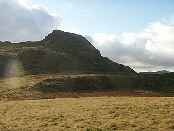
Summit of Green Grag from the plateau to the north
|
|
| Highest point | |
| Elevation | 489 m (1,604 ft) |
| Prominence | c. 145 m |
| Parent peak | Harter Fell |
| Listing | Wainwright |
| Geography | |
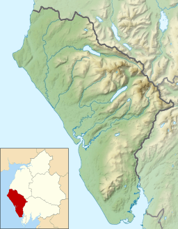
| Location | Cumbria, England |
| Parent range | Lake District, Southern Fells |
| OS grid | SD200982 |
| Topo map | OS Landranger 89,90, Explorer OL6 |
Green Crag is a mountain, known as a fell, located in the beautiful Lake District in England. It stands between two valleys, Eskdale and the Duddon valley. It is part of the Southern Fells area.
Contents
Exploring Green Crag's Landscape
The areas at the top of Eskdale and the Duddon valley are separated by a long ridge. This ridge stretches for about 15 miles, eventually reaching the sea near Black Combe. From a mountain called Crinkle Crags, the first fells on this ridge are Hard Knott, Harter Fell, and then Green Crag.
Alfred Wainwright, a famous guidebook writer, thought that the mountains south and west of Green Crag were not as interesting for walking. He said Green Crag was the end of the "fellwalking country." However, other writers later disagreed. They added mountains like Great Worm Crag, Yoadcastle, Whitfell, and Black Combe to their lists. Wainwright himself later included these smaller hills in another book.
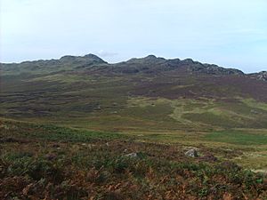
Green Crag is the tallest of several rocky tops that stick out from the Birker Fell moorland. When you look from Eskdale, these rocky outcrops create a cool, jagged skyline. Birker Fell is a roughly square area, about two miles across. Eskdale is to its north, and the River Duddon is to its south.
Above the wooded Eskdale valley, there are steep cliffs. Over these cliffs, you can see waterfalls like Stanley Force and Birker Force. Stanley Force is easy to reach by walking paths. Farmers from Eskdale used to collect peat (a type of soil made from decayed plants) from this flat area. You can still find old paths and small huts they used. On this side of the fell, you can also find the remains of the Gate Gill iron mine. Hematite (a type of iron ore) was dug out here in the 1880s. The Duddon valley side has gentler slopes, divided by stone walls into long fields for grazing animals. These fields support farms along the valley between Ulpha and Seathwaite.
To the east of Green Crag, there's a wet, marshy area before the land rises again to Harter Fell. The western edge is marked by the Birker Fell Road. This road is open and offers great views of the Scafells. It reaches its highest point at 885 feet and has sharp turns at both ends. Because of this, it often closes in winter due to snow and ice. Beyond this road, the moorland climbs up to Yoadcastle. From there, it turns south, forming a clearer ridge that leads all the way to Black Combe.
The highest point of Green Crag is on a line of rocky outcrops, called tors. These tors break through the peat and grass towards the east of the flat top. As you travel south from the Eskdale edge, you'll see tops like Kepple Crag, Great Whinscale, Crook Crag (1,538 feet), Green Crag, and White How. The ridge then turns west towards the Fell Road, passing over Great Worm Crag (1,400 feet). Some people think Great Worm Crag is a separate mountain. To the west of the main ridge is Low Birker Pool. This is a shallow tarn (a small mountain lake) that feeds Birker Force waterfall. It's held in place by a low mound of rocks and dirt, and Tarn Crag overlooks it.
Green Crag's Geology
The very top of Green Crag is made of bare rock. This rock was formed from lava that flowed out of ancient volcanoes. It's part of what geologists call the Birker Fell Formation, which belongs to the Borrowdale Volcanic Group. This means the mountain was created by volcanic activity a very long time ago!
Reaching the Summit
The top of Green Crag is made of bare rock. To reach the summit, you'll usually need to approach from the north or west. You might need to do a little bit of easy climbing. From the small pile of stones, called a cairn, on the summit, you get an amazing view of the southern fells. You can also see the sea directly to the south.
How to Climb Green Crag
You can climb Green Crag from the Birker Fell Road. There are some places to park off the road. If you're starting from Eskdale, a good way to go is by following the "sled gate." This is an old path that was used for dragging peat on sleds, and it climbs near Birker Force waterfall. You can also reach the flat top near Kepple Crag. From the Duddon valley, there are marked paths through the pine tree forests. These paths start from different Forestry car-parks.
 | DeHart Hubbard |
 | Wilma Rudolph |
 | Jesse Owens |
 | Jackie Joyner-Kersee |
 | Major Taylor |


