Whitfell facts for kids
Quick facts for kids Whitfell |
|
|---|---|

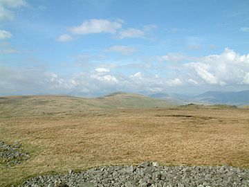
From the summit of Kinmont Buck Barrow, looking to the flat summit of Burn Moor and Whitfell (centre), with the Duddon Valley right
|
|
| Highest point | |
| Elevation | 573 m (1,880 ft) |
| Prominence | c. 221 m |
| Parent peak | Black Combe |
| Listing | Marilyn, Outlying Wainwright |
| Geography | |
| OS grid | SD158929 |
| Topo map | OS Landranger 96 |
Whitfell (sometimes called Whit Fell) is a hill in the southwestern part of the Lake District in England. It stands about 573 meters (1,880 feet) tall. This makes it a significant point between two other hills, Black Combe and Harter Fell. It's located on a wide ridge west of the beautiful Duddon Valley.
Contents
Exploring Whitfell: A Lake District Hill
Whitfell is not as famous as some other Lake District hills, but it offers a quiet adventure. It is the highest point in its area. The hill is mostly covered in grass and is a popular spot for sheep to graze.
What You Can See From the Top
From the very top of Whitfell, you can see amazing views all around. You can look down the entire Duddon Valley, right to where it meets the sea. To the west, you can spot the hills of Coniston.
You can also see the fells (hills) of Eskdale, including famous peaks like Scafell and Bowfell. Much of western Cumbria is visible, along with the estuaries (where rivers meet the sea) of the Rivers Esk, Mite, and Irt. On a clear day, you might even see the Isle of Man far out in the sea!
The Summit and Its Features
The top of Whitfell has a very large pile of stones called a cairn. Cairns are often built by people to mark a summit or a path. The stones here might even come from an ancient burial mound, known as a tumulus.
A special path called a bridleway crosses the northern part of the hill. This type of path is open for people walking, cycling, and even riding horses.
Following Alfred Wainwright's Footsteps
Many people who love walking in the Lake District know about Alfred Wainwright. He was a famous fell walker and writer. He wrote a series of guidebooks about the fells.
In his book The Outlying Fells of Lakeland, Wainwright describes a route that includes Whitfell. This route often starts from the Corney Fell road. It also visits other nearby hills like Burn Moor (about 543 meters or 1,780 feet), Kinmont Buck Barrow (about 535 meters or 1,754 feet), and Buck Barrow (about 548 meters or 1,799 feet). These walks offer a great way to explore this quieter part of the Lake District.
 | Jessica Watkins |
 | Robert Henry Lawrence Jr. |
 | Mae Jemison |
 | Sian Proctor |
 | Guion Bluford |


