Glaramara facts for kids
Quick facts for kids Glaramara |
|
|---|---|

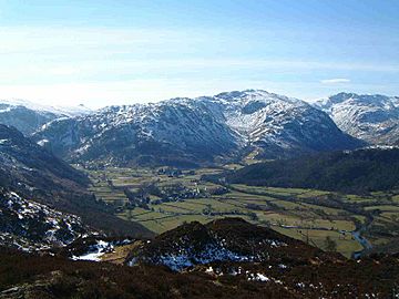
Glaramara with the hanging valley of Combe Gill (centre right) seen from Grange Fell, 6 km to the north
|
|
| Highest point | |
| Elevation | 783 m (2,569 ft) |
| Prominence | 121 m (397 ft) |
| Parent peak | Scafell Pike |
| Listing | Hewitt, Nuttall, Wainwright |
| Naming | |
| English translation | "Hill with the mountain hut by a chasm" |
| Language of name | Old Norse |
| Geography | |
| Location | Cumbria, England |
| Parent range | Lake District, Southern Fells |
| OS grid | NY246104 |
| Topo map | OS Landrangers 89,90, Explorer OL4 |
Glaramara is a tall hill, also known as a fell, located in the beautiful Lake District in Cumbria, England. It's a big part of a long ridge that stretches for over six kilometers. This ridge goes from a place called Stonethwaite in Borrowdale all the way up to a famous mountain pass called Esk Hause. Glaramara's top, or summit, is 783 meters (2,569 feet) high. It sits right in the middle of this ridge, separating two valleys: Langstrath and Grains Gill. Walking along this ridge is a fun and challenging adventure because it has other smaller hills, many mini-tops, and even some tiny lakes called tarns.
Contents
What's in a Name?
The name Glaramara sounds quite unique and pleasant. It used to only refer to the rocky top of the hill. Now, it's the official name for the whole fell. Like many places in the Lake District, its name comes from old Old Norse words. It means "Hill with the mountain hut by a chasm."
The Shape of Glaramara
One of the most interesting parts of Glaramara is Combe Gill. This is a "hanging valley" on its northern side. It was formed by huge glaciers during the last ice age. Imagine a smaller valley that was left hanging high above a deeper, main valley.
Combe Gill is full of rocky cliffs. It's also home to the Dove Nest Caves, which are the only natural caves in the Lake District. A rockslide from Dove Nest Crags partly covers the caves, which have three entrances.
On its east and west sides, Glaramara slopes down steeply. These slopes are rocky and covered in loose stones called scree. To the south, the ridge continues from Glaramara's summit for about two kilometers. It goes over several smaller tops before reaching Allan Crags and then descending to Esk Hause.
Climbing Glaramara
Most people start climbing Glaramara from the Borrowdale road. This road is found between Rosthwaite and Seatoller. You can choose to climb up either the east or west ridge of Combe Gill.
The east ridge is often considered the best path. This route lets you climb Rosthwaite Fell and its smaller peak, Dovenest Top (632 meters). On this journey, you'll also pass over two other tops of Glaramara. These are Combe Door Top (676 meters) and Combe Head (735 meters). Combe Head offers amazing views down into Combe Gill. From there, it's a short climb to reach Glaramara's twin summits.
Views from the Top
The view from the top of Glaramara is truly amazing! Because Glaramara is in the middle of the Lake District, and deep valleys separate it from other fells, you get a fantastic 360-degree view. Looking north down Borrowdale towards Skiddaw is especially beautiful.
Many hikers continue south along the ridge after reaching Glaramara's summit. They head towards the next main fell, Allen Crags. On this path, they pass three more smaller tops. These include Looking Steads (775 meters), Glaramara South Top (721 meters), and High House Tarn Top (684 meters).
The Glaramara Fell Race
Glaramara is also famous for its annual Glaramara Fell Race. This race used to happen in April, but in 2006, it was moved to July. It's an eight-kilometer (five-mile) race that starts from the Glaramara Outdoor Centre near Seatoller.
Racers climb 640 meters (2,100 feet) to reach Glaramara's summit. The fastest runners usually finish the course in about 47 minutes. It's a tough but exciting challenge!
 | Claudette Colvin |
 | Myrlie Evers-Williams |
 | Alberta Odell Jones |


