Harter Fell (Mardale) facts for kids
Quick facts for kids Harter Fell |
|
|---|---|

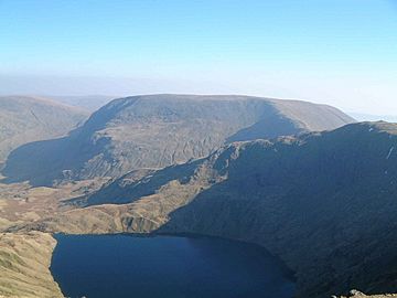
Harter Fell seen from High Street with Blea Water in the foreground
|
|
| Highest point | |
| Elevation | 778 m (2,552 ft) |
| Prominence | 149 m (489 ft) |
| Parent peak | High Street |
| Listing | Hewitt, Wainwright, Nuttall |
| Geography | |
| Location | Cumbria, England |
| Parent range | Lake District, Far Eastern Fells |
| OS grid | NY459093 |
| Topo map | OS Explorer OL5, Explorer OL7 |
Harter Fell is a mountain in the eastern part of the Lake District in England. Its top, called the summit, is where three ridges meet. Harter Fell is also the starting point for three valleys: Mardale, Longsleddale, and the valley of the River Kent.
Contents
What Does Harter Fell Look Like?
The top part of Harter Fell looks like a horseshoe shape. It opens towards the southeast. This ridge is narrow and covered in grass. A new fence runs along it.
There are smaller tops on both sides of the horseshoe. The southern ridge goes over places called The Knowe and Brown Howe. It then connects to Kentmere Pike. The eastern ridge has a rocky top called Little Harter Fell (about 681 meters high). It also has Adam Seat (about 666 meters high), marked by a large stone. This ridge goes down to Gatescarth Pass and then rises again to Branstree.
A third ridge connects to the middle of the horseshoe shape. It looks a bit like a tuning fork. This ridge is rockier and goes quickly down to Nan Bield Pass. From there, you can connect to Mardale Ill Bell and High Street.
The western slopes of the fell are quite steep. They are above the Kentmere Reservoir. There's an area where the land has slipped in the past, near Dry Gill. A lower ridge sticks out into Kentmere. It separates Kentmere from the valley of Ullstone Gill. This ridge is named after The Ullstone, a large, unusual boulder.
The horseshoe shape at the top of Harter Fell forms the start of Wren Gill. This is the main stream that feeds the River Sprint in Longsleddale. Near the bottom of the slope, at Wrengill Quarry, the stream disappears into holes in the ground. It then comes out again a short distance lower down. The slopes on this southeastern side of the fell are gentle and mostly covered in grass.
To the north, above Mardale, Harter Fell looks different. There are large, steep cliffs that drop about 400 meters into the valley. More cliffs line the ridge going down to Nan Bield. Below these cliffs is a beautiful mountain lake called Small Water. This lake is in a bowl-shaped hollow and is about 15 meters deep. It has brown trout and perch fish.
How to Climb Harter Fell
The mountain passes of Nan Bield and Gatescarth were once important trade routes. They connected Mardale to Kentmere and Longsleddale. Today, these routes are mainly used by walkers. They are the easiest ways to get onto Harter Fell. The upper parts of these paths still have the original zig-zags for steep sections.
Most people start their climb from Mardale. You can drive along the shore of Haweswater to get there. Harter Fell's summit is about 1.5 kilometers southwest of the carpark. It is about 550 meters higher than the carpark. You cannot climb directly up because of the cliffs. So, people usually climb Harter Fell using Gatescarth Pass to the east or Nan Bield Pass to the west. These passes also offer the easiest access from Kentmere or Longsleddale.
A longer way to climb Harter Fell starts from the Kent valley. This route follows the ridge that separates it from Longsleddale. It includes climbing Kentmere Pike along the way. This can be part of a longer walk called the Kentmere Horseshoe. This walk also includes the Ill Bell ridge. You can also combine climbing Harter Fell with other mountains. These include Branstree, Mardale Ill Bell, and High Street. This creates a high-level circuit around Mardale. Finally, you can climb directly from Longsleddale. This involves walking up the grassy slopes above Wrengill Quarry.
What's at the Top of Harter Fell?
At the very top of Harter Fell, there is a pile of stones called a cairn. This cairn has many pieces of iron from an old fence. Some of these pieces look like pitchforks sticking up. If you see them suddenly on a foggy day, it can be a bit spooky. There is a second cairn to the north with similar decorations. The view from the top is great all around. If you move to the edge of the cliffs, you can see the entire length of Haweswater.
Why Harter Fell is Special
Harter Fell was once listed as a "Marilyn." A Marilyn is a hill that rises at least 150 meters above the land around it. However, it was later found that Harter Fell just missed this height by 1 meter. So, it is no longer officially a Marilyn.
- Lake District Walks - Harter Fell Walk
 | Madam C. J. Walker |
 | Janet Emerson Bashen |
 | Annie Turnbo Malone |
 | Maggie L. Walker |


