Branstree facts for kids
Quick facts for kids Branstree |
|
|---|---|

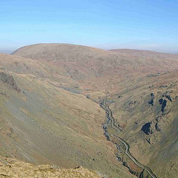
Branstree seen from Goat Scar to the South. The Gatescarth Pass track is seen in the valley below
|
|
| Highest point | |
| Elevation | 713 m (2,339 ft) |
| Prominence | 137 m (449 ft) |
| Parent peak | Harter Fell |
| Listing | Hewitt, Nuttall, Wainwright |
| Naming | |
| English translation | corruption of "Brant Street" |
| Language of name | Old English |
| Geography | |
| Location | Cumbria, England |
| Parent range | Lake District, Far Eastern Fells |
| OS grid | NY477100 |
| Topo map | OS Explorer OL5, Explorer OL7 |
| Listed summits of Branstree | ||||
| Name | Grid ref | Height | Status | |
|---|---|---|---|---|
| Branstree NE Top (High Howes) | NY487103 | 673 m (2,207 ft) | Nuttall | |
Branstree is a cool mountain, or "fell," located in the eastern part of England's amazing Lake District. It stands tall, looking over the beautiful Mardale valley and the huge Haweswater Reservoir.
Contents
What is Branstree Like?
A group of high fells forms a circle around the top of Mardale valley. This circle starts with High Raise in the north. It then curves around over High Street and Harter Fell. Finally, it reaches Branstree and Selside Pike in the south.
As you move along this ridge, the landscape changes. You'll see fewer rocky cliffs and more smooth, grassy hillsides. Branstree is the first fell where grass covers most of the ground. It starts to look more like the Pennines than the typical rocky Lake District. From many directions, Branstree looks like a smooth, rounded hill with a wide, flat top.
Branstree's Connections
Branstree is connected to Harter Fell by a path called Gatescarth Pass. This path is about 1,900 feet high. It used to be a main route for people walking between Mardale and Longsleddale valleys. Even today, walkers use its well-planned zig-zag trails. Trade between these two valleys stopped when the Haweswater Reservoir was made bigger in the 1940s. This caused the village of Mardale Green to disappear under the water.
East of Branstree, there's a large area of wild moorland. This land stretches for about five miles between the Mardale and Swindale valleys. Right next to Branstree, there's another fell that's almost the same height. It's not named on maps, but some guidebooks call it 'High Howes'. However, the famous fell-walker Alfred Wainwright thought it was just part of Branstree.
South of Branstree, another ridge connects to Tarn Crag. This path goes between the Mosedale valley and the start of Longsleddale. This area is wide and can be quite boggy. Mosedale is a valley that runs west from Swindale.
Mosedale Cottage
Near the bottom of Branstree, close to Mosedale, is Mosedale Cottage. This small stone hut is a shepherd's bothy. It's about two miles from the nearest road and is only used sometimes. Its white walls are very helpful for hikers to find their way when the weather gets bad. Behind the cottage, you can see the remains of an old quarry.
The eastern part of Branstree, called Howes, is even featured in one of Alfred Wainwright's books, The Outlying Fells of Lakeland.
The Haweswater Aqueduct Project
Between Branstree and High Howes, you'll find a small mountain lake, called a "tarn." There are also the remains of a special stone pillar. This unusual stone and concrete structure has a split at the top. This split was used to create a sight line. It was originally surrounded by a wooden frame, which has now fallen apart.
This pillar is one of four built when the Haweswater aqueduct was being constructed. An aqueduct is like a giant pipe that carries water. Below Branstree, Tarn Crag, and Great Howe, is the first part of this huge pipeline. It carries water from the reservoir all the way to Manchester.
This tunnel is about 1,300 feet underground at this point. It needed 250 tons of dynamite to blast through the rock! When it was built in the 1930s, it was the longest pipeline of its kind in Britain. The tunnel comes out in Longsleddale, where you can still see the piles of rock that were dug out.
Reaching the Top of Branstree
The very top of Branstree is wide and quite flat. This means the views aren't always perfect in every direction. Taller fells to the west can block some of the scenery. However, you can get a great view of the Pennines and Howgill Fells.
Stone walls and fences follow the paths from Gatescarth, Tarn Crag, and Selside Pike. They all meet near the summit. There's a small pile of stones, called a cairn, a little to the north. For an even better view of Mardale, you can go to Artlecrag Pike. This smaller peak, just north of the main summit, has two cool stone pillars built from nearby flaky rocks.
How to Climb Branstree
You can climb Branstree from the three valleys around it. Gatescarth Pass offers a way up from the roads in Mardale and Longsleddale. Other paths climb from near Mosedale Cottage. You can also start from the shore of Haweswater, close to where the old Mardale Corpse Road begins.
 | Bessie Coleman |
 | Spann Watson |
 | Jill E. Brown |
 | Sherman W. White |


