Tarn Crag (Far Eastern Fells) facts for kids
Quick facts for kids Tarn Crag (Far Eastern Fells) |
|
|---|---|

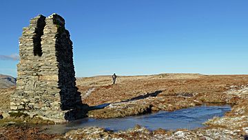
The surveying pillar on Tarn Crag
|
|
| Highest point | |
| Elevation | 664 m (2,178 ft) |
| Prominence | c. 160 m |
| Parent peak | High Street |
| Listing | Wainwright, Marilyn, Nuttall, Hewitt |
| Geography | |
| Location | Cumbria, England |
| Parent range | Lake District, Far Eastern Fells |
| OS grid | NY488078 |
| Topo map | OS Explorer OL7 |
Tarn Crag is a mountain, or "fell," located in the beautiful Lake District in England. It's found in the eastern part of the Lake District, specifically in an area called the Far Eastern Fells, near a valley named Longsleddale. It's good to know there's another mountain with the same name, Tarn Crag, in a different part of the Lake District, close to the village of Grasmere.
Contents
Exploring Tarn Crag's Landscape
North of a place called Sadgill, the Longsleddale valley becomes very narrow. It has tall, rocky walls on both sides. On the eastern side, a big rock feature called Buckbarrow Crag stands out.
Above Buckbarrow Crag, hidden from the valley, is another layer of rock. This is Tarn Crag itself. The mountain gets its name from being close to the top. Tarn Crag is often seen as the place where the Lake District's landscape changes into the style of the Pennines.
Away from its steep western side, Tarn Crag has long, gentle slopes. These slopes are covered in rough grass and heather. You won't see many rocks sticking out here.
Northern and Southern Borders
The northern edge of Tarn Crag is a path for walkers. This path goes from Longsleddale to Mosedale. It crosses a wet, marshy area that is about 1,555 feet high.
A stream called Mosedale Beck starts here. It begins its long journey northeast towards Swindale. Beyond this marshy area, the land rises again to the north. This leads up to Selside Brow and then to Branstree. Branstree is the highest point in the Lake District east of Longsleddale.
South of Tarn Crag, there's another marshy dip in the land. This separates Tarn Crag from a similar mountain called Grey Crag. This dip holds a tiny lake, or "tarn," called Greycrag Tarn. It's actually a few small pools where a larger body of water used to be.
The water from Greycrag Tarn flows into Longsleddale through a stream called Galeforth Gill. But another stream, Little Mosedale Beck, flows east from the same marsh.
Streams and Ridges
Mosedale Beck and Little Mosedale Beck meet about a mile northeast of Tarn Crag. These streams mark the eastern edges of the mountain. A ridge slopes down to where the streams meet. This ridge is called Brunt Tongue.
At Brunt Tongue, there's a small area of conifer trees. This patch of trees makes the spot easy to see from far away. There are not many other trees in this open, moorland landscape.
The Haweswater Aqueduct Project
A fence crosses Tarn Crag just east of its summit. This fence runs along the Sleddale Fells. It stretches from Selside Pike in the north to Grey Crag and its smaller peak, Harrop Pike, in the south. This fence can help people find their way when the weather is bad.
Surveying Pillars
Another man-made feature near the summit is the remains of a surveying pillar. This is an unusual structure made of stone and concrete. It has a split at the top, which was used for sighting lines. It used to have a wooden frame around it, but that has now rotted away.
This pillar is one of four such structures. They were built when the Haweswater aqueduct was being constructed. An aqueduct is like a giant pipeline or channel that carries water from one place to another.
The Long Tunnel
Below Branstree and Tarn Crag is the first part of the pipeline. This pipeline carries water from the Haweswater Reservoir all the way to Manchester. The tunnel is about 1,300 feet below the summit.
To blast through the rock for the tunnel, workers needed 250 tons of gelignite. Gelignite is a powerful explosive. When it was built in the 1930s, this tunnel was the longest pipeline of its kind in Britain. The tunnel comes out into Longsleddale below a place called Great Howe. You can still see the leftover rock and dirt from the digging there.
Reaching Tarn Crag's Summit
The view from the top of Tarn Crag is mostly grassy. It might not be the best for seeing other mountains. However, you get a wide view in other directions. You can see from Morecambe Bay all the way to the Pennines. A small part of Windermere lake can also be seen to the southwest.
How to Climb Tarn Crag
You can climb Tarn Crag from Longsleddale. One way is to go via Great Howe. Another way is from a point north of Buckbarrow Crag. You can also take longer routes from Swindale or Shap, by following Brunt Tongue.
 | Bessie Coleman |
 | Spann Watson |
 | Jill E. Brown |
 | Sherman W. White |


