Mardale Ill Bell facts for kids
Quick facts for kids Mardale Ill Bell |
|
|---|---|

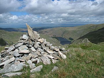
A cairn at the summit
|
|
| Highest point | |
| Elevation | 760 m (2,490 ft) |
| Prominence | c. 14 m |
| Parent peak | High Street |
| Listing | Wainwright, |
| Geography | |
| Location | Cumbria, England |
| Parent range | Lake District, Far Eastern Fells |
| OS grid | NY448102 |
| Topo map | OS Explorer OL5, Explorer OL7 |
Mardale Ill Bell is a cool mountain, or "fell," found in England's amazing Lake District. It rises southwest of Haweswater Reservoir. This fell sits right on the edge between two valleys, Mardale and Kentmere. It's also the highest point on the southeast ridge of High Street, a bigger mountain nearby.
Contents
Exploring Mardale Ill Bell's Landscape
The Kentmere valley starts southwest of Mardale Ill Bell. Here, rough slopes covered in loose rocks, called scree, lead down to Kentmere Reservoir. Mardale Ill Bell has a short, grassy ridge, named Lingmell End. This ridge splits the top of the valley into two parts.
Cool Water Features
The northeast side of Mardale Ill Bell forms a rocky background for Blea Water. This perfect corrie tarn is the deepest in the Lake District, reaching 207 feet deep! A "corrie tarn" is a lake formed in a bowl-shaped hollow carved by a glacier.
Blea Water's outflow flows into Haweswater. It joins with the water from another tarn called Small Water. Between these two tarns, Mardale Ill Bell has a rocky ridge called Piot Crag. Two levels of crags drop down to where the waters meet at Mardale Waters.
Ancient Routes and Passes
Southeast of the summit, a narrow, rough ridge drops to Nan Bield Pass. This pass is about 2,100 feet high. From there, the path rises again over rocky steps to Harter Fell.
Nan Bield Pass was an old trading route. It connected Kentmere with the village of Mardale Green. Sadly, Mardale Green was flooded in the 1940s when Haweswater was made bigger. Near Small Water, you can find stone shelters along the path. These show how important the pass used to be. Each shelter can fit one person in an emergency, but you have to crawl inside!
Northwest from Mardale Ill Bell, the grassy ridge crosses a wet area. Then, it widens into a large, triangular plateau. High Street and Thornthwaite Crag are at the other two corners of this plateau. An old Roman road crosses this area from north to south.
Reaching the Summit
The summit of Mardale Ill Bell has two large cairns on the grass. A "cairn" is a pile of stones used as a marker. The northern cairn is the actual highest point. Looking west, your view is blocked by taller mountains. However, you can get a great view of the Ill Bell ridge and the Coniston mountain range. If you stand at the edge of the crags, you can also see Blea Water and Small Water below.
How to Climb Mardale Ill Bell
The most popular ways to climb Mardale Ill Bell are from the Mardale side. From the end of the road, you can use the Nan Bield Pass. Or, you can reach the impressive Piot Crag from the shore of either Blea Water or Small Water.
If you are coming from Kentmere, Nan Bield Pass is the clearest route. You can also try a pathless climb up to the top of Lingmell End.
 | Percy Lavon Julian |
 | Katherine Johnson |
 | George Washington Carver |
 | Annie Easley |


