Great Rigg facts for kids
Quick facts for kids Great Rigg |
|
|---|---|

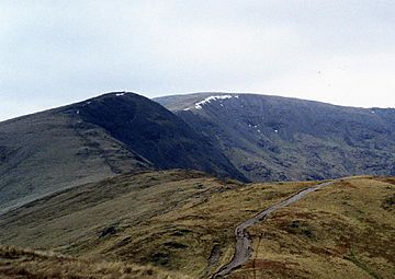
Great Rigg (left) with Fairfield
behind from Heron Pike. |
|
| Highest point | |
| Elevation | 766 m (2,513 ft) |
| Prominence | 31 m (102 ft) |
| Parent peak | Fairfield |
| Listing | Hewitt, Nuttall, Wainwright |
| Geography | |
| Location | Cumbria, England |
| Parent range | Lake District Eastern Fells |
| OS grid | NY355104 |
| Topo map | OS Landranger 90, OS Explorer 5 |
Great Rigg is a cool fell (which is another word for a mountain or hill) located in the beautiful Lake District in England. It stands about 7 kilometres (that's about 4½ miles) north-north-west of a town called Ambleside. This fell reaches a height of 766 metres (or 2,513 feet) above sea level.
Many people enjoy climbing Great Rigg as part of a longer, exciting walk called the Fairfield horseshoe. This is a big circular route, about 16 kilometres long, that starts and finishes in Ambleside. The name 'Great Rigg' comes from the Old English Language. 'Rigg' means a bumpy or knobbly ridge, which perfectly describes how this fell looks!
Contents
What is Great Rigg Like?
Great Rigg is often seen as part of a larger mountain, Fairfield. It's like a smaller bump on one of Fairfield's southern ridges. Even though it's not super tall on its own, it's still important enough to be called a Hewitt. A Hewitt is a hill in England, Wales, or Ireland that is at least 2,000 feet (609.6 m) high and has a drop of at least 30 metres (98 feet) on all sides.
If you look at Great Rigg from the south-west, especially near a village called Grasmere, it looks really impressive. From that angle, its top seems to stand out and dominate the valley below.
The Sides of Great Rigg
The eastern side of Great Rigg is quite rocky. Here, a place called Stone Cove drops down to Rydal Beck, which is a small stream. On the western side, the fell is mostly covered in grass. This grassy slope gently falls away towards Tongue Gill, another stream.
To the north and south, Great Rigg connects to other fells through long ridges. Fairfield is about 1.5 kilometres (0.9 miles) away to the north. To the south, Heron Pike is about 2.5 kilometres (1.6 miles) away. There's also a smaller ridge that goes south-west towards Grasmere. On this ridge, you'll find Stone Arthur, which is another famous fell listed in the Wainwrights. It overlooks Grasmere from its shoulder.
How Was Great Rigg Formed?
The rocks that make up the top of Great Rigg are called Volcaniclastic sandstone. These rocks were formed from volcanic ash and fragments that settled down and hardened over time. Below this sandstone, you'll find another type of rock called dacitic lapilli-tuff. This rock is also formed from volcanic material, specifically small rock fragments (lapilli) that were ejected from a volcano and then cemented together. So, Great Rigg has a volcanic past!
Climbing Great Rigg
As we mentioned, most people climb Great Rigg as part of the popular Fairfield horseshoe walk. This is a great way to see several fells in one go!
However, you can also climb Great Rigg directly from Grasmere. If you choose this route, you would walk up the south-west ridge. On this path, you would pass by Stone Arthur on your way up. This walk can even be extended to include Fairfield and Seat Sandal before you head back to Grasmere. This longer circular walk is about 10 kilometres (6.2 miles) in total.
The Summit of Great Rigg
When you reach the very top of Great Rigg, you'll find a large pile of stones called a cairn. This cairn is so well-known that it's even named on detailed maps as "Greatrigg Man."
From the summit, you get amazing views of the Lakeland mountains to the west. One of the coolest things you'll notice is how many lakes and tarns (which are small mountain lakes) you can see. There are at least ten large bodies of water clearly visible from the top, making for a truly spectacular sight!
 | William L. Dawson |
 | W. E. B. Du Bois |
 | Harry Belafonte |


