Rampsgill Head facts for kids
Quick facts for kids Rampsgill Head |
|
|---|---|

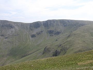
Seen from Rest Dodd, 1.5 km to the NW.
|
|
| Highest point | |
| Elevation | 792 m (2,598 ft) |
| Prominence | c. 40 m |
| Parent peak | High Raise |
| Listing | Hewitt, Wainwright, Nuttall |
| Geography | |
| Location | Cumbria, England |
| Parent range | Lake District, Far Eastern Fells |
| OS grid | NY443128 |
| Topo map | OS Explorer OL5 |
Rampsgill Head is a special kind of mountain, known as a fell, located in the amazing Lake District in England. It stands proudly to the west of the Haweswater Reservoir. This fell is like a central hub because three different mountain ridges spread out from it in different directions: north-east, north-west, and south.
Contents
Exploring Rampsgill Head's Shape
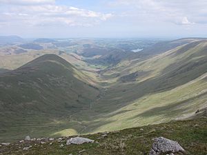
Rampsgill Head is part of the Far Eastern Fells, a group of mountains in the Lake District. Imagine a long line of mountains, like a spine, stretching north from a place called High Street. This mountain spine meets a deep, U-shaped valley named Rampsgill, which comes up from the south.
How the Ridges Branch Out
When the mountain spine reaches Rampsgill valley, it splits into two main arms. These arms curve around the valley system of Martindale.
- The first arm goes north-west, leading over other fells like The Knott and Rest Dodd. It eventually reaches Place Fell, which is located above the top of Ullswater lake.
- The second arm continues the main ridge of the Far Eastern Fells towards the north-east. It passes over High Raise and ends near the bottom of Ullswater at Heughescar Hill.
Valleys in the Middle
Between these two curving mountain arms are several beautiful valleys. These include Boredale, Bannerdale, Rampsgill, and Fusedale. Together, these valleys are known as Martindale.
Rampsgill Head's Special Spot
Rampsgill Head sits right where these three main ridges meet. Its highest point, or summit, is a little to the north-east. There's also a smaller peak nearby called Kidsty Pike. Famous fell walker Wainwright considered Kidsty Pike a separate fell, and many people agree with him. This means Rampsgill Head itself covers a fairly small area, even though it's one of the higher fells.
Understanding the Ridges
- The ridge going south towards High Street is quite narrow. In some spots, it's barely wider than the path you walk on, especially at a place called the Straits of Riggindale.
- The north-eastern ridge is also narrow once you pass Kidsty Pike.
- However, the north-western ridge is much wider. The summit of The Knott is located off to the left of this broader ridge.
Steep Sides of the Fell
The northern side of Rampsgill Head drops very steeply, about 1,800 feet, into the bowl-shaped upper part of Rampsgill valley. The south-western side, above Hayeswater, and the south-eastern side, above Riggindale (which feeds into Haweswater), are also very rocky and steep. These craggy sides make it difficult for an average walker to climb directly up.
Paths to the Top
You can find clear paths on Rampsgill Head.
- An ancient Roman road, also called High Street, crosses the fell to the south-east of the summit. This path follows the ridge from High Street to High Raise.
- There is also a clear path along the third ridge that leads to The Knott. These paths make it easier to explore the area.
What You'll Find at the Summit
The very top of Rampsgill Head is mostly covered in grass, with a few rocks sticking out. A small pile of stones, called a cairn, marks the highest point. There's an even larger cairn located right at the edge of the steep northern face.
Amazing Views from the Top
From the summit, you get a fantastic view looking west towards the Helvellyn mountain range. You can also see the beautiful lakes of Ullswater and Brothers Water. Many people start their climbs to Rampsgill Head from other fells or from nearby villages like Patterdale, Hartsop, and Mardale Head.
 | William M. Jackson |
 | Juan E. Gilbert |
 | Neil deGrasse Tyson |


