
Place Fell facts for kids
Quick facts for kids Place Fell |
|
|---|---|

Summit ridge of Place Fell
|
|
| Highest point | |
| Elevation | 657 m (2,156 ft) |
| Prominence | c. 262 m |
| Parent peak | High Street |
| Listing | Marilyn, Hewitt, Wainwright, Nuttall |
| Geography | |

Place Fell
Location in Lake District
|
|
| Location | Cumbria, England |
| Parent range | Lake District, Far Eastern Fells |
| OS grid | NY405169 |
| Topo map | OS Explorer OL5 |
Place Fell is a cool hill in the beautiful Lake District in England. It sits right by Ullswater, a famous lake. Its sides drop steeply down towards the villages of Glenridding and Patterdale.
Contents
Exploring Place Fell's Shape
Imagine a giant horseshoe of high ground. This horseshoe wraps around the Martindale area, which has valleys that drain into Ullswater. Place Fell is at the very end of this horseshoe ridge. To its south, you'll find Angletarn Pikes. On all other sides, Place Fell stands alone, surrounded by deep valleys.
Where Place Fell Meets the Lake
The northern and western sides of Place Fell are bordered by Ullswater. Most of these sides drop sharply to the lake's edge. You can see many trees on the lower parts of these slopes.
There's a special spot called Silver Point. This is a small piece of land sticking out into the lake. It's formed by Silver Crag, a smaller hill that stands apart from the main mountain.
A path runs along the lakeshore from Sandwick in the north to Patterdale in the south. A famous walker named Alfred Wainwright said this was the most beautiful and rewarding walk in Lakeland. South of the lake, Place Fell's steep slopes continue above Patterdale village. They reach a spot called Boredale Hause, which is above the Goldrill Beck valley.
The Eastern Side and Nearby Hills
Place Fell's eastern side faces Boredale. This is one of the valleys in the Martindale area. This side is also very steep and has many rocky outcrops.
If you travel up Boredale, the valley slowly turns southwest. It looks like it might meet Patterdale and cut Place Fell off from its neighbors. But a thin strip of high ground at Boredale Hause (about 1,300 feet high) connects Place Fell to the other mountains in the Far Eastern Fells.
You can find a tiny old ruin at the top of this pass. On maps, it's called the 'Chapel in the Hause'. It's a very unusual place for a church! From Boredale Hause, you can follow a good path south to Angletarn Pikes. First, you'll climb a smaller peak called Stony Rigg (1,610 feet).
Other paths from this busy crossing point lead to Patterdale, Boredale, and Hartsop. There's also a route up Steel Edge to the very top of Place Fell.
The Top of Place Fell
The top of Place Fell is a wide, flat area. The highest point is in the southwest corner. From here, a rocky ridge called Hart Crag stretches northeast across the top. It has several small pools of water called tarns.
If you keep going in this direction, the ground gets narrower as it goes down to Low Moss. Beyond Low Moss are two smaller peaks: High Dodd (1,645 feet) and Sleet Fell (1,240 feet).
Another ridge goes north from the summit area. It starts at a rock called The Knight (1,800 feet). This rock looks like an impressive peak when you see it from the north. But from behind, it's easy to miss.
From The Knight, the ridge goes down over Bleaberry Knott (1,675 feet) and Low Birk Fell. It then curves east above the middle part of Ullswater. Low Birk Fell has a cool beacon, which is a tall stone pile. You can easily see it from Sandwick. Between the Bleaberry Fell and High Dodd ridges is the valley of Scalehow Beck. This beck helps drain the northern part of Place Fell.
Reaching the Summit
At the very top of Place Fell, you'll find a special column used for mapping (a triangulation column). There's also a stone pile (a cairn). They are about ten yards apart on two slightly different high spots.
The cairn is above Ullswater. From here, you get amazing views up the valleys facing you. You can see from Glencoyne all the way around to Kirkstone Pass. The rough eastern faces of the Helvellyn range look especially striking.
How to Climb Place Fell
You can climb Place Fell from Patterdale. One way is to go via Boredale Hause. Another way is to go more directly up the side between Bleaberry Knott and The Knight.
You can also start your climb from Sandwick. From there, you can go up either of the two northeastern ridges. Or, you can climb from Boredale via Boredale Hause.
The climb from the shores of Ullswater to the top of Place Fell is about 512 meters (1,680 feet) high. But the paths are not too steep. You won't need to use your hands to scramble up rocks. There are very few places where you'd need to scramble, even if you go off the main path.
Images for kids
-
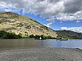
Place Fell as seen from the other side of Ullswater

