Angletarn Pikes facts for kids
Quick facts for kids Angletarn Pikes |
|
|---|---|

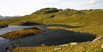
Angle Tarn and Angletarn Pikes
|
|
| Highest point | |
| Elevation | 567 m (1,860 ft) |
| Prominence | c. 80 m |
| Parent peak | Rest Dodd |
| Listing | Wainwright |
| Geography | |
| Location | Cumbria, England |
| Parent range | Lake District, Far Eastern Fells |
| OS grid | NY413148 |
| Topo map | OS Explorer OL5 |
Angletarn Pikes is a cool mountain, or "fell," found in England's beautiful Lake District. It's close to a village called Patterdale. What makes it special is the small lake, or "tarn," right at its top. That's how it got its name!
Exploring Angletarn Pikes
Angletarn Pikes is part of a long, horseshoe-shaped ridge. This ridge wraps around the Martindale area, which is a system of valleys. These valleys send their water north into Ullswater, a large lake.
Other mountains nearby on this ridge include Place Fell to the north. To the south, you'll find Brock Crags. There's also a smaller ridge called Beda Fell. It sticks out from Angletarn Pikes into Martindale. This ridge separates two valley heads: Boredale and Bannerdale.
The western side of the mountain is very steep. It has rocky cliffs like Dubhow and Fall Crags. The long eastern side, above Bannerdale, also has many crags. Heck Crag is the biggest one there. The narrow northern slopes above Boredale are steep but less rocky. They are cut by a deep valley called Freeze Beck.
North of the summit, a long ridge goes down to Stony Rigg. This leads to a popular spot for walkers called Boredale Hause. From here, paths go down to villages like Hartsop and Patterdale. Another path crosses Beda Fell to Bannerdale. At Boredale Hause, you can see the tiny ruins of a building. It's called 'Chapel in the Hause' on maps. It's quite unusual to find a church at 1,300 feet up a mountain pass! From Boredale Hause, a good path continues north. It goes up Steel Edge to Place Fell.
The north-east ridge to Beda Fell is also easy to follow. A clear path goes over several rocky bumps. Then it rises to the top, called Beda Head.
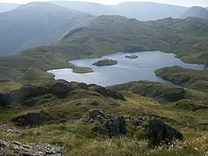
South of Angletarn Pikes is Angle Tarn itself. This lake is about a quarter of a mile long. It has an island in the middle. The tarn makes a beautiful view with the Pikes in the background. The lake sits in a dip on the ridge. Its water flows west through a break in the ridge. This water forms the Angletarn Beck ravine. The main ridge goes east of the tarn. It rises above the Bannerdale side. It then goes up to an unnamed top at 1,870 feet. This spot is actually higher than Brock Crags. But Alfred Wainwright, a famous fell writer, considered Brock Crags the main peak.
Summit Views
Angletarn Pikes gets its name from the two rocky peaks at its top. These two peaks are about 200 yards apart. The northern peak is the highest one. The other peak is about six feet lower. From the southern peak, you get a clear view of Angle Tarn. Wainwright said it's "among the best of Lakeland tarns." The wider view from the top is amazing. You can see the Helvellyn mountain range. You can also see the main ridge of the Far Eastern Fells across Martindale.
How to Climb Angletarn Pikes
You can climb Angletarn Pikes by starting at Boredale Hause. This means you can begin your walk from places like Patterdale, Bridgend, Hartsop, or Boredale Head. Another way to climb is from Martindale Old Church. From there, you can go up the Beda Fell ridge or via Angle Tarn. The path from Patterdale is often used as the first part of a longer climb to High Street.
See Also
 | Valerie Thomas |
 | Frederick McKinley Jones |
 | George Edward Alcorn Jr. |
 | Thomas Mensah |


