Beda Fell facts for kids
Quick facts for kids Beda Fell |
|
|---|---|

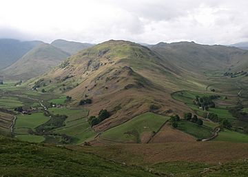
Seen from Hallin Fell, 3 km to the north.
|
|
| Highest point | |
| Elevation | 509 m (1,670 ft) |
| Prominence | c. 60 m |
| Parent peak | Angletarn Pikes |
| Listing | Wainwright |
| Geography | |
| Location | Cumbria, England |
| Parent range | Lake District, Far Eastern Fells |
| OS grid | NY427171 |
| Topo map | OS Explorer OL5 |
Beda Fell is a beautiful fell (which is a type of mountain or hill) located in the Lake District in England. It stands just south of Ullswater, one of the Lake District's most famous lakes. This fell acts like a natural divider, separating two valleys called Boredale and Bannerdale, both part of the wider Martindale area.
Contents
Exploring Beda Fell's Landscape
Beda Fell is part of a longer ridge that stretches from Rampsgill Head to Place Fell. Think of it like a branch coming off a main tree trunk. Beda Fell is one of these "branches" or spurs that runs north, creating separate valleys.
How Beda Fell Was Formed
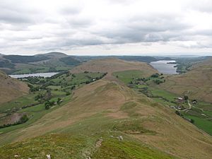
The fell starts from its "parent" peak, Angletarn Pikes. From there, it stretches north for about two and a half miles. It eventually slopes down towards the valley near a place called Sandwick. Along the way, Beda Fell gets wider and rises to its highest point, which is known as Beda Head.
What the Fell Looks Like
The very top of Beda Fell is covered in soft grass. However, its sides are quite steep and have many rocky cliffs, known as crags. On the western side, facing Boredale, you'll find crags like Brock Crag and Low Brock Crag.
The eastern side, which faces Bannerdale, curves outwards around the summit. Here, you can see more rocky areas such as Allen Crag, Ewe Crag, Raven Crag, and Thrang Crag. These crags drop down in layers from the ridge. Further north, above Howe Grain, there are even more rock faces like Nickles and Winter Crag.
The Path to the Summit
As you walk down from Angletarn Pikes, Beda Fell begins with several rocky knolls (small, rounded hills) on a narrower ridge. The last of these knolls is called Bedafell Knott. After this, the path becomes mostly grassy. You'll cross two small dips before the ridge climbs up to Beda Head, the very top of Beda Fell.
North of the summit, the ridge becomes very narrow between the crags. It then drops down to a road that connects Howtown to Sandwick. Finally, it reaches the valley floor where Howe Grain and Boredale meet.
The Summit View
The very top of Beda Fell, Beda Head, is a grassy mound. You'll find a small cairn there, which is a pile of stones often used as a landmark. From the summit, you get a great view of the tall fells around you.
Even though the ridge is quite wide, you can still see parts of Ullswater lake. It peeks out on both sides of Hallin Fell, another nearby fell.
Climbing Beda Fell
There are several exciting ways to climb Beda Fell.
Popular Routes
- You can walk straight up the ridge from the main road.
- Another option is to start your walk a little way up either Boredale or Howe Grain. From there, a path goes across the fell just below a smaller peak called Winter Crag.
- A clear path continues south from the summit of Beda Fell, leading you to Angletarn Pikes.
- Near Bedafell Knott, there's a bridleway (a path suitable for walkers and horse riders). This path connects Patterdale (through Boredale Hause) to the end of the Bannerdale road at Dale Head Farm.
Another Adventure Route
You can also take an upper path behind Winter Crag Farm. This path goes north through bracken (a type of fern) to the first high point on the ridge. From there, you walk south along the ridge and up to Beda Fell Knott.
For your way down, you can either go back the same way. Or, you can continue walking over Angle Tarn Pikes. Then, you can descend south to Patterdale. From Patterdale, you can catch a fun steamer boat across Ullswater to Howtown or Glenridding, making for a great end to your adventure!
 | William Lucy |
 | Charles Hayes |
 | Cleveland Robinson |


