
Hallin Fell facts for kids
Quick facts for kids Hallin Fell |
|
|---|---|

Hallin Fell
Location in Lake District
|
|
| Highest point | |
| Elevation | 388 m (1,273 ft) |
| Prominence | 163 m (535 ft) |
| Parent peak | High Street |
| Listing | Marilyn, Wainwright |
| Geography | |
| Location | Cumbria, England |
| Parent range | Lake District, Far Eastern Fells |
| OS grid | NY433198 |
| Topo map | OS Explorer OL5 |
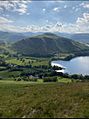
Hallin Fell is a lovely hill located in the English Lake District. It's special because it's surrounded on three sides by the beautiful lake, Ullswater.
Contents
What is Hallin Fell Like?
Hallin Fell might seem like a small hill compared to other mountains in the Lake District. However, it stands out on its own. This is because a deep dip in the land, called The Hause, separates it from the nearby Steel Knotts ridge. This makes Hallin Fell look like a completely separate hill from almost every angle.
How Hallin Fell Shapes the Valleys
Hallin Fell acts like a plug at the end of the Martindale valley system. Water flowing from smaller valleys like Rampsgill, Bannerdale, and Boredale has to go around the west side of the hill. Eventually, this water reaches Ullswater at a place called Sandwick. Water from Fusedale and the valley above Howtown flows around the east side of the hill. It then meets the lake at Howtown Wyke. The southern edges of Hallin Fell are clearly marked by these streams and the road from Howtown to Sandwick. This road has a very steep, winding climb up to The Hause.
Slopes and Crags
The hill is round in shape. Its southern and western sides have smooth slopes. A famous fellwalker named Alfred Wainwright once said that you could easily walk up the southern side "comfortably in bare feet"! The other sides of the hill have rougher ground. The very northern tip of Hallin Fell, known as Geordie's Crag, sticks out into Ullswater. It helps separate the middle and lower parts of the lake.
Reaching the Top of Hallin Fell
The very top of Hallin Fell is covered in grass. You'll find several small bumps and some rocks sticking out of the ground there.
The Summit Cairn
At the highest point, there's a tall, square stone pile called a cairn. You'll also see many other smaller cairns at different spots on the summit. These cairns often mark good viewpoints.
Amazing Views from the Top
Even though Hallin Fell isn't one of the tallest hills, the views from its summit are fantastic! From the top, you can see across Martindale Common, the High Street mountain, Helvellyn, Blencathra, and of course, all of Ullswater. It's a great spot to take in the beauty of the Lake District.

Ways to Climb Hallin Fell
There are several easy ways to climb Hallin Fell.
Popular Walking Routes
- From Howtown: The walk from Howtown up to the stone cairn at the top is short and not too difficult.
- From The Hause: You can also find many paths leading up from St Peter's Church at The Hause.
- From Howtown Hamlet: There are also routes starting from the small village of Howtown.
Lakeside Walk and Steamer Trip
A popular walk goes around the northern side of Hallin Fell. This route is part of the scenic lakeside path from Howtown to Patterdale. It mostly goes through wooded areas and has some gentle parts where you might climb over rocks. You can even combine this walk with a ride on the Ullswater steamer boat. This makes for a wonderful day out exploring the lower parts of the fells.

Images for kids
-
Hallin Fell photographed whilst walking down from Bonscale Pike

