The Knott facts for kids
Quick facts for kids The Knott |
|
|---|---|

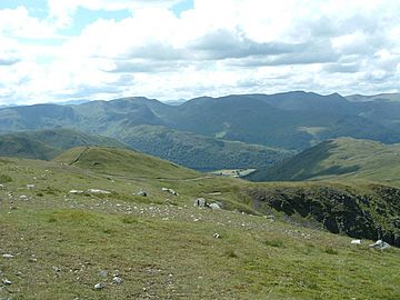
The Knott from Rampsgill Head. The Knott is the small hump in the left foreground.
|
|
| Highest point | |
| Elevation | 739 m (2,425 ft) |
| Prominence | c. 14 m |
| Parent peak | Rampsgill Head |
| Listing | Wainwright |
| Geography | |
| Location | Cumbria, England |
| Parent range | Lake District, Far Eastern Fells |
| OS grid | NY436127 |
| Topo map | OS Explorer OL5 |
The Knott is a type of mountain called a fell in the beautiful Lake District area of England. It stands tall above a lake called Hayeswater. This fell is part of the Far Eastern Fells, which is a group of mountains. The Knott is considered an "outlier" of Rampsgill Head. This means it's a smaller peak connected to the main, taller mountain. It's the highest point on the ridge that goes from Rampsgill Head to another fell called Rest Dodd.
Contents
Exploring The Knott's Shape and Surroundings
The Knott has a unique shape and location. It sits on a ridge that stretches northwest from Rampsgill Head. The Knott itself sticks out from the southwest side of this ridge.
Unusual Water Flow on The Knott
One interesting thing about The Knott is how water flows here. A small stream, called Well Gill, actually runs along the top of the wide ridge for almost half a mile! After this, it finally flows down the southwest side of the mountain and becomes Sulphury Gill.
Lakes and Slopes Near The Knott
Below The Knott, on its southwest side, you'll find the small lake of Hayeswater. The slopes leading down to the lake are very steep and covered in loose rocks, known as scree slopes. A deep, narrow valley, or gully, also runs down the side of the fell just south of the top. When you look at The Knott from this side, it looks like an impressive cone-shaped peak. However, from other directions, you can see that it's not as tall as Rampsgill Head.
The Ridge to Rest Dodd
The northeast side of the ridge slopes down over rough ground. This leads to the start of Rampsgill valley, which is part of the Martindale area. After passing Sulphury Gill, the ridge from The Knott turns north. It then leads to the rounded, dome-shaped top of Rest Dodd.
Reaching The Knott's Top
The very top of The Knott is covered in grass. You'll find a small pile of stones, called a cairn, there. A wall that runs along the ridge passes very close to the summit.
Amazing Views from The Summit
From the top of The Knott, you get great views, especially towards the west. You can see all the mountains in the Lake District that are over 3,000 feet tall! You can also spot Ullswater, which is one of the largest lakes. If you move a little to the southwest, you can also see Hayeswater and Brothers Water.
How to Climb The Knott
Most people who climb The Knott start their journey from a village called Hartsop. They usually go past Hayeswater lake. There's an old path that zig-zags up the mountain from just below the lake. Even though it's a zig-zag path, some modern hikers like to take shortcuts straight up the corners. A clear path also leads south from The Knott. This path goes across the slopes of Rampsgill Head and eventually leads to High Street, another famous fell.
 | Misty Copeland |
 | Raven Wilkinson |
 | Debra Austin |
 | Aesha Ash |


