Hayeswater facts for kids
Quick facts for kids Hayeswater |
|
|---|---|
 |
|
| Location | Lake District, Cumbria |
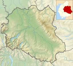
| Coordinates | 54°30′05″N 2°52′48″W / 54.50139°N 2.88000°W |
| Type | natural (formerly reservoir) |
| Primary inflows | Hayeswater Gill |
| Basin countries | United Kingdom |
| Surface elevation | 1,400 ft (425 m) |
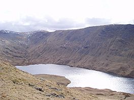
Hayeswater is a beautiful small lake located in the amazing Lake District of Cumbria, England. It's a natural lake that was once used to store water for people, like a big water tank!
Contents
Exploring Hayeswater
Where is Hayeswater?
Hayeswater is found about 1.6 kilometers (or one mile) southeast of a small village called Hartsop. This village is in the lovely Patterdale Valley. The lake sits peacefully between two hills: The Knott to its east and Gray Crag to its west. It's quite high up, at almost 425 meters (1,400 feet) above sea level!
From Reservoir to Natural Lake
Even though Hayeswater is a natural lake, a dam was built there in 1908. This turned it into a reservoir. A reservoir is like a giant bathtub that holds water for towns. Hayeswater used to supply water to the town of Penrith in Cumbria.
However, Hayeswater stopped being used as a reservoir in 2005. Then, in the summer of 2014, a company called United Utilities removed the dam. This helped the lake return to its natural state, becoming a mountain tarn once again. A tarn is a small mountain lake. They also built a new footbridge. This bridge crosses Hayeswater Beck, which is the stream flowing out of the lake. It's about 250 yards downstream from where the water leaves the tarn.
Water Flow and Surroundings
Water flows into Hayeswater from the south. This water comes from a stream called Hayeswater Gill. This stream starts near an old Roman road known as the High Street. Hayeswater Gill then continues its journey. It eventually joins another stream near Cow Bridge. This other stream flows out of Brothers Water, another beautiful lake nearby.
 | Charles R. Drew |
 | Benjamin Banneker |
 | Jane C. Wright |
 | Roger Arliner Young |


