Bannerdale Crags facts for kids
Quick facts for kids Bannerdale Crags |
|
|---|---|

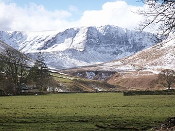
Bannerdale Crags from Mungrisdale
|
|
| Highest point | |
| Elevation | 683 m (2,241 ft) |
| Prominence | c. 37 m |
| Parent peak | Bowscale Fell |
| Listing | Wainwright, Hewitt, Nuttal |
| Geography | |
| Location | Cumbria, England |
| Parent range | Lake District, Northern Fells |
| OS grid | NY335290 |
| Topo map | OS Landranger 89, 90 OS Explorer OL5 |
Bannerdale Crags is a fell (a type of mountain or hill) located in the beautiful English Lake District. It stands proudly between two other fells, Blencathra and Bowscale Fell, in the area known as the Northern Fells. It's a popular spot for hikers and offers amazing views.
Contents
What is Bannerdale Crags Like?
Bannerdale Crags is shaped like a long, narrow ridge that stretches from the northwest to the southeast. While the name "Crags" originally referred only to the steep, rocky side facing northeast, it now describes the entire fell.
How the Fell is Shaped
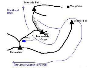
From a nearby mountain called Blencathra, gentle slopes lead down towards Bannerdale Crags. These slopes eventually split into two paths. One path goes towards Mungrisdale Common. The other, which has some rocks sticking out, goes down to a low point called a 'col'. This col is about 616 meters (2,020 feet) high.
From this low point, a stream called Blackhazel Beck flows northwest. It eventually joins the River Caldew. On the opposite side of the col, another river, the Glenderamackin, begins its journey.
The Crags and Valleys
The northeast side of Bannerdale Crags is very dramatic. It has a long wall of rocky cliffs that stretch for about a mile. These cliffs drop sharply, sometimes as much as 180 meters (600 feet), into the valley below. This valley is home to Bannerdale Beck, a stream that flows into the Glenderamackin River.
One interesting feature is a rocky spur that sticks out from the cliff face, almost directly below the summit. This spur provides a challenging but rewarding path for climbers.
To the north, the summit ridge of Bannerdale Crags connects to Bowscale Fell through a wide, grassy area. To the southeast, the fell ends suddenly at a place called White Horse Bent. Here, the land drops steeply down to the Glenderamackin River. This river takes a very winding path around Bannerdale Crags and another fell called Souther Fell before heading west towards Keswick.
Reaching the Top: The Summit
The very top of Bannerdale Crags is smooth and covered in grass. The highest point is a bit set back from the steep cliffs. It's marked by a small pile of flat stones called a cairn. Closer to the cliff edge, there's another cairn. On older maps, this was called a 'currick', which is a stone shelter built by shepherds.
Amazing Views from the Summit
The view from the summit is surprisingly wide and beautiful. You can see the Furness Fells (also known as the Coniston Fells) about 32 kilometers (20 miles) away to the south. The Eastern Fells and Far Eastern Fells are also visible. But many people think the best view is of Sharp Edge and the eastern side of Blencathra, which looks very impressive from here.
Rocks and Old Mines
Like many fells in the Northern Fells, Bannerdale Crags is mostly made of rocks from the Kirk Stile Formation. These rocks are part of the Skiddaw Group. They are mostly made of layered mudstone and siltstone, with some greywacke sandstone mixed in. These rocks were formed a very long time ago, during the Ordovician period.
Mining History
There were once mines at Bannerdale Crags.
- Bannerdale Lead Mine: This mine was located right at the base of the main cliffs. It operated mainly in the late 1800s. Miners dug for lead (a heavy metal) and other minerals like galena and blende. They had two main tunnels, each over 30 meters (100 feet) long.
- Graphite Level: Further up, below the summit, there were workings known as the graphite level. Graphite is a form of carbon, similar to what's in pencil lead. It's not clear how much graphite was found here, as the tunnel was only dug a few feet.
- Saddleback Old Mine: This mine is to the south of Bannerdale Crags, near the low point that connects it to Blencathra. This mine also looked for lead. However, the rock here mostly contained limonite, which is an iron ore. People tried to sell this as a pigment (a coloring material), but it wasn't very successful. The mine stopped operating after 1894.
How to Hike Bannerdale Crags
There are a few ways to climb Bannerdale Crags.
Starting from Mungrisdale
One popular way is to start from the village of Mungrisdale, which is to the east. You can follow the Glenderamackin River until it meets Bannerdale Beck. From there, a path goes up the east spur almost directly to the summit. The scenery gets better as you go, and there's a bit of easy climbing near the top. Another option from Mungrisdale is to take a wide, easy path that leads up to the ridge between Bannerdale Crags and Bowscale Fell.
Starting from Scales
A less direct way is to start from Scales. First, you cross a valley called Mousthwaite Combe to reach the Glenderamackin River, south of the fell. From here, you can either climb directly up White Horse Bent, or you can follow an old miners' track. This track leads to Saddleback Old Mine and the source of the river.
 | Lonnie Johnson |
 | Granville Woods |
 | Lewis Howard Latimer |
 | James West |


