
Bowscale Fell facts for kids
Quick facts for kids Bowscale Fell |
|
|---|---|

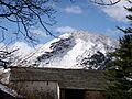
The Tongue, Bowscale Fell from Mungrisdale
|
|
| Highest point | |
| Elevation | 702 m (2,303 ft) |
| Prominence | c. 90 m |
| Parent peak | Blencathra |
| Listing | Wainwright, Hewitt, Nuttal |
| Geography | |

Bowscale Fell
Location in Lake District
|
|
| Location | Cumbria, England |
| Parent range | Lake District, Northern Fells |
| OS grid | NY334305 |
| Topo map | OS Landranger 89, 90 OS Explorer OL5 |
Bowscale Fell is a beautiful hill located in the Lake District in England. It stands tall above the small village of Mungrisdale. This fell is part of the Northern Fells and is connected to the larger Blencathra mountain group.
Like many fells, Bowscale Fell has different kinds of slopes. Its western side is generally smooth and rounded. However, the eastern side features dramatic, rocky cliffs and crags.
Contents
What is Bowscale Fell Like?
Bowscale Fell has a wide, grassy ridge that curves around a valley called Bannerdale. You might even find some small, boggy areas and tiny lakes, called tarns, on the northern part of this ridge.
One interesting part of the fell is a ridge called The Tongue. From below, it looks like a steep, pyramid-shaped peak. It hides the higher ground behind it, making it look very impressive.
Bowscale Tarn: A Mysterious Lake

On the northern side of Bowscale Fell, you'll find a special lake called Bowscale Tarn. This tarn sits in a bowl-shaped hollow, formed by ancient glaciers. It's quite deep, about 60 feet!
Long ago, during the Victorian era, Bowscale Tarn was a very popular spot for tourists. People would ride ponies up to see its wild and moody beauty. Today, it's not as famous, but it's still a cool place to visit.
There's even a legend about Bowscale Tarn! People used to say that two immortal fish lived in its waters. Some versions of the story even claimed these fish could talk! Above the tarn is Tarn Crag, which is the steepest part of the fell.
Where Does the Water Go?
The water from the western and northern sides of Bowscale Fell flows into the River Caldew. This river travels northeast all the way to Carlisle. Eventually, it joins the River Eden and then flows into the Solway Firth.
It's interesting to note that the water from the western slopes of Bowscale Fell flows east, while the water from the eastern slopes flows west towards Keswick and the River Derwent. This shows how Bowscale Fell acts as a natural dividing line for water flow in the area.
Reaching the Top of Bowscale Fell

The top of Bowscale Fell is mostly covered in grass, but there are also some scattered stones. At the very highest point, you'll find a shelter to protect you from the wind. There's also a small pile of stones, called a cairn, pointing towards Bowscale Tarn.
From the summit, you get amazing views! You can see Blencathra and its famous Sharp Edge. You can also catch a surprising glimpse of the North Western Fells through a gap in the mountains.
How to Walk Up Bowscale Fell
There are several ways to climb Bowscale Fell, especially if you start from Mungrisdale:
- Easy Path: You can follow a gentle path that leads to the hollow at the head of Bannerdale.
- The Tongue: For a steeper climb, you can turn off the main path and go directly up the end of The Tongue ridge.
- Direct Route: Following Bullfell Beck offers the most direct way to the summit.
- East Ridge: Many people enjoy walking along the eastern ridge, which has gentle ups and downs.
If you start from the small village of Bowscale, you can still follow the old Victorian pony route to Bowscale Tarn. From there, a grassy path leads you up through Tarn Crag to the summit.
For a much longer adventure, you can reach the ridge between Bowscale Fell and Bannerdale Crags from the Caldew Valley to the west. This opens up starting points like Mosedale or even Skiddaw House.
Images for kids
-
The Tongue, Bowscale Fell from Mungrisdale
-
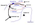
Sketch map of Bowscale Fell
-
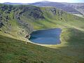
Bowscale Tarn seen from Tarn Crags.
