Calf Crag facts for kids
Quick facts for kids Calf Crag |
|
|---|---|

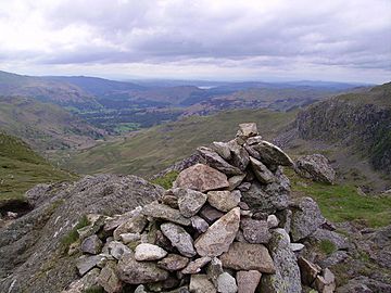
Summit Cairn
|
|
| Highest point | |
| Elevation | 537 m (1,762 ft) |
| Prominence | c. 40 m |
| Parent peak | High Raise |
| Listing | Wainwright |
| Geography | |
| Location | Cumbria, England |
| Parent range | Lake District, Central Fells |
| OS grid | NY302105 |
| Topo map | OS Landranger 90 |
Calf Crag is a cool fell (which is a type of mountain or hill) located in the amazing Lake District in England. It sits on the eastern side of a bigger mountain area called the High Raise massif. It's a popular spot for hikers and offers some great views!
Contents
What is Calf Crag?
Calf Crag is part of the Central Fells, which are a group of mountains running north to south in the Lake District. Think of it like a big, wide ridge with several rocky tops. It's not the tallest mountain around, but it's an important part of the landscape.
Where is Calf Crag Located?
Calf Crag is surrounded by different valleys and streams. To the north, you'll find Wythburndale. To the south is Far Easedale, and to the east is Greenburn. These valleys have streams that flow down from the mountain. The Wyth Burn flows north towards Thirlmere lake. The Far Easedale Gill and Green Burn flow south towards the River Rothay and eventually into Windermere lake. This means Calf Crag sits on a special line that divides where the water flows, either north or south!
Connecting Fells
The top of Calf Crag is quite wide, about a mile across. From here, two narrow ridges stretch out to the east. One ridge goes north towards Steel Fell. The other ridge goes south, passing over Gibson Knott before ending at Helm Crag. If you head southwest from Calf Crag, the ground gets rockier and leads up to Sergeant Man and then to High Raise. So, Calf Crag is like a central hub connecting to several other interesting fells.
Exploring the Summit
The very top of Calf Crag is a rocky area with a small crag (a steep, rugged rock face) just to the south. You'll find a neat little cairn (a pile of stones used as a landmark) there. There's also a small tarn (a mountain lake) between the main summit and another smaller top to the west.
What Can You See from the Top?
While some taller mountains block the view to the west, you can still enjoy a fantastic sight of the beautiful Grasmere lake. Behind it, you'll see the impressive Helvellyn range rising up. It's a great spot for taking photos and enjoying the peaceful scenery.
Paths and Trails
There are several paths on Calf Crag that lead to other fells like Steel Fell, Gibson Knott, and Sergeant Man. A famous long-distance walking path called the Coast to Coast Walk also passes nearby. This path, known as the bridleway over Greenup Edge, goes southwest of Calf Crag as it travels from Borrowdale to Far Easedale.
How to Climb Calf Crag
The easiest way to start your climb up Calf Crag is from the village of Grasmere. You have a couple of main routes:
- Via Green Burn: This route takes you directly up a grassy slope between two rocky areas called Pike of Carrs and Rough Crag.
- Via Far Easedale: This path leads you to the ridge behind the summit.
You can also start from the head of Thirlmere lake and walk up Wythburndale, but be prepared for some boggy (wet and muddy) sections!
Popular Hikes
Many hikers enjoy making the climb to Calf Crag part of a longer adventure called the "Greenburn Horseshoe." This popular circular walk also includes climbing Steel Fell, Gibson Knott, and Helm Crag, making for a full day of exploring the Lake District's stunning fells.
 | William M. Jackson |
 | Juan E. Gilbert |
 | Neil deGrasse Tyson |


