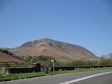
Steel Fell facts for kids
Quick facts for kids Steel Fell |
|
|---|---|

Steel Fell from the Traveller’s Rest,
near Grasmere village. |
|
| Highest point | |
| Elevation | 553 m (1,814 ft) |
| Prominence | c. 70 m (230 ft) |
| Parent peak | High Raise |
| Listing | Wainwright |
| Geography | |
| Location | Cumbria, England |
| Parent range | Lake District, Central Fells |
| OS grid | NY319112 |
| Topo map | OS Landranger 90, Explorer OL5 |
Steel Fell is a beautiful hill, also called a fell, located in the famous Lake District in England. It sits between two lovely places: Thirlmere and Grasmere.
This fell looks like a triangle from above. It has three main ridges, which are like long, narrow hills, that stretch out in different directions: north, west, and south-east. Steel Fell is west of the main road that goes through Dunmail Pass. You can climb it from the top of the pass, or from the villages of Grasmere and Wythburn.
Contents
What is Steel Fell Like?
Steel Fell is part of the Central Fells in the Lake District. It's like the end of a long arm that reaches out from a bigger fell called High Raise. Between Steel Fell and High Raise are two smaller hills named Codale Head and Calf Crag.
Steel Fell has valleys on its sides. To the north is Wythburndale, and to the south-west is the valley of Green Burn. The eastern side of the fell looks down towards Dunmail Raise, which is a mountain pass.
Steel Fell's Shape and Ridges
Because Steel Fell is shaped like a triangle, it has three main ridges:
- The northern ridge drops down quickly to the top of Thirlmere lake at a place called Steel End.
- The south-eastern ridge gently slopes down towards Grasmere village. This part starts at Cotra Breast.
- The eastern ridge connects Steel Fell to Calf Crag. This is the next fell you would reach if you were walking a popular route around the Greenburn valley. There's a small dip between them with a few tiny pools of water called tarns.
Where Does the Water Go?
The southern side of Steel Fell has cliffs called Blakerigg Crag, which lead down to Greenburn. Greenburn is a stream that flows into Grasmere lake. On the north-western side, Wythburndale flows towards Thirlmere lake. The eastern side of Steel Fell drops down over Ash Crags to the Dunmail Raise pass.
Two streams, both called Raise Beck, flow down the pass – one north and one south. These streams follow the main road that connects Keswick and Ambleside. This means Steel Fell sits right on the main line that divides where water flows in the Lake District. Rain that falls on the southern slopes eventually reaches the sea at Morecambe Bay. But rain that falls just a few steps to the north ends up in the River Derwent and flows to the sea at Workington.
What is Steel Fell Made Of?
The rocks that make up Steel Fell are quite interesting! The very top of the fell and the area called Ash Crags are made of a type of rock that formed from ancient volcanic eruptions. It's a mix of volcanic ash and rock fragments that were once hot and sticky.
The rest of the fell is mostly made of similar volcanic rocks, but with different layers. There's also a large section of a different type of volcanic rock called andesite that can be seen near the surface above Wythburndale.
Reaching the Top
The very top of Steel Fell is called Dead Pike. It's a flat, triangular area about half a mile wide, and it has many small pools of water called tarns. At the summit, you'll find a large pile of reddish stones, known as a cairn.
From the top, the best views are towards the north, where you can see Blencathra mountain rising above Thirlmere lake. If you look to the south-west, you'll see a wonderful view of many mountains, stretching all the way to the Coniston Fells.
How to Climb Steel Fell
Most people climb Steel Fell using the south-east ridge. This path usually starts at Gill Foot, where a small road from Grasmere crosses the Green Burn stream.
Another way to climb is from Steel End, at the head of Thirlmere. From there, you can find a path up the north ridge. Or, you can take a longer route up the Wythburn valley and then climb onto the ridge that leads to Calf Crag. It's also possible to climb directly up the eastern side from the top of Dunmail Raise pass.
 | Dorothy Vaughan |
 | Charles Henry Turner |
 | Hildrus Poindexter |
 | Henry Cecil McBay |


