Troutbeck Tongue facts for kids
Quick facts for kids Troutbeck Tongue |
|
|---|---|

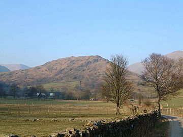
Troutbeck Tongue as seen from the approach along Ing Lane
|
|
| Highest point | |
| Elevation | 364 m (1,194 ft) |
| Prominence | c.70 m |
| Parent peak | Froswick |
| Listing | Wainwright |
| Geography | |
| Location | Cumbria, England |
| Parent range | Lake District, Far Eastern Fells |
| OS grid | NY422064 |
| Topo map | OS Explorer OL7 |
Troutbeck Tongue is a small hill, also called a fell, located in the beautiful Lake District in England. It's about 5 kilometers (3 miles) northeast of Ambleside. This fell is special because it's one of 214 hills listed in Alfred Wainwright's famous guidebooks. Many hikers love to climb all the "Wainwrights" to complete the list.
Because Troutbeck Tongue is not too high and is close to a main road, it's a great choice for a half-day trip. It's especially nice to visit when bigger mountains are covered in clouds.
Contents
What is Troutbeck Tongue Like?
Troutbeck Tongue sticks out southwest from the main Ill Bell ridge. This ridge is a long line of hills. Troutbeck Tongue is just north of another hill called Froswick.
How Water Shapes the Fell
This fell acts like a natural wall, separating two streams: Trout Beck and Hagg Gill. Hagg Gill is a smaller stream that flows into Trout Beck. These two streams almost meet behind the fell. The low point, or col, that connects Troutbeck Tongue to Froswick is only about 295 meters (968 feet) high.
Ancient Marks on the Landscape
In this low area, you can find many old cairns. A cairn is a pile of stones, often built by people a long time ago. These cairns are at the bottom of the fell's long, grassy back-slope. The back of the fell is very different from its southern tip. The southern end drops steeply down rocky cliffs towards an area called Troutbeck Park.
How to Climb Troutbeck Tongue
Most people start their climb from the village of Troutbeck. This village is on the A592 road, about 5 kilometers (3 miles) north of Windermere.
The Walk to the Base
From the village, it's a pleasant walk to the bottom of the fell. You follow the Trout Beck stream along a path called Ing Lane. This path leads to Troutbeck Park Farm.
Beatrix Potter's Connection
This farm, covering about 7.7 square kilometers (1,900 acres), was bought by the famous children's book author and illustrator Beatrix Potter in 1923. She bought it to protect it from being developed into buildings. When she passed away in 1943, she left this farm and 13 other farms she owned in the Lake District to the National Trust. The National Trust is an organization that protects important places and nature.
Starting the Climb
The actual climb up the fell begins at the farm. It's quite a steep path, and you'll need to go over some rocky areas, walls, and fences. But because the fell isn't very tall, the climb is short, usually less than 30 minutes. You might even see signs of old quarrying near the top, where people once dug for stone. These spots are marked on the Ordnance Survey map.
Reaching the Top
The very top of Troutbeck Tongue is grassy. The views from the summit are a bit limited because higher fells surround it. However, you get a really good view looking south down the Troutbeck valley. From here, you can clearly see Windermere, which is England's largest lake.
 | Emma Amos |
 | Edward Mitchell Bannister |
 | Larry D. Alexander |
 | Ernie Barnes |


