Froswick facts for kids
Quick facts for kids Froswick |
|
|---|---|

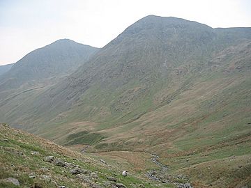
Ill Bell and Froswick (on the right) from the upper valley of the River Kent
|
|
| Highest point | |
| Elevation | 720 m (2,360 ft) |
| Prominence | c. 75 m |
| Parent peak | Ill Bell |
| Listing | Wainwright, Nuttall, Hewitt |
| Geography | |
| Location | Cumbria, England |
| Parent range | Lake District, Far Eastern Fells |
| OS grid | NY435085 |
| Topo map | OS Explorer OL7 |
Froswick is a mountain, also called a fell, located in the amazing Lake District area of England. It sits on a narrow ridge between two beautiful valleys: Kentmere and Troutbeck.
Contents
About Froswick and Its Neighbors
Froswick is surrounded by other fells. To its north is Thornthwaite Crag, and to its south is Ill Bell. Froswick is not as tall as these nearby fells. It also doesn't have a clear path directly to its top.
Because of this, people often see Froswick as a stop on their way to Ill Bell. It's also part of a longer walking route called the Kentmere Horseshoe. Froswick even looks a lot like Ill Bell, especially when you see the ridge from the side.
The Sides of the Fell
The western side of Froswick, facing Troutbeck, is steep and smooth. There's a deep ditch called Blue Gill that cuts down this side. This ditch feeds into a stream called Hagg Gill.
The eastern side, facing Kentmere, is rougher. It has loose rocks and slopes down to the River Kent. This is just above the Kentmere Reservoir.
A Special Ridge
Froswick has a unique feature that Ill Bell doesn't: a smaller ridge that branches off. This narrow piece of high ground sticks out into the Troutbeck valley from the western side of Froswick. It helps separate Trout Beck from its main stream, Hagg Gill. On this smaller ridge, you'll find a modest hill called Troutbeck Tongue.
Walking the Ridge
The paths leading north and south from Froswick are narrow and offer great views. If you head north, you'll follow an old fence above some rocky cliffs called Wander Scar. The ridge then gets wider as it reaches the flat top of Thornthwaite Crag.
When you walk towards Ill Bell, you'll pass above an area called Over Cove on the Kentmere side. After that, you'll need to do a bit of rocky climbing to reach the top of Ill Bell. From Froswick, you can easily see the impressive stone piles (called cairns) on the tops of both nearby fells.
An Ancient Roman Road
Besides the popular walking path along the ridge, Froswick also has an old Roman road on its western side. This road climbs up the valley of Hagg Gill. It then crosses the ridge below Thornthwaite Crag and heads straight for a fell called High Street, which is named after the road itself.
This ancient road follows several worn grooves in the hillside. It is also known by another name: Scot Rake. Imagine Roman soldiers walking here thousands of years ago!
Reaching the Summit
The very top of Froswick is small and grassy, not as rocky as Ill Bell. You'll find a small stone pile (a cairn) there. The view from the summit is a bit limited by the taller fells around it. However, you can still get a good look at the famous Scafells and the beautiful Langdales.
How to Climb Froswick
You can climb directly up Froswick using paths like Scot Rake or Blue Gill, starting from the Troutbeck valley. On the Kentmere side, there are no clear paths. However, there's a grassy area to the north of the fell that helps you avoid the steepest, rockiest parts.
 | Aaron Henry |
 | T. R. M. Howard |
 | Jesse Jackson |


