
Bonscale Pike facts for kids
Quick facts for kids Bonscale Pike |
|
|---|---|

Seen from the Howtown zig zags, one km to the SW.
|
|
| Highest point | |
| Elevation | 524 m (1,719 ft) |
| Prominence | less than 10 m |
| Parent peak | Loadpot Hill |
| Listing | Wainwright |
| Geography | |

Bonscale Pike
Location in Lake District
|
|
| Location | Cumbria, England |
| Parent range | Lake District, Far Eastern Fells |
| OS grid | NY453201 |
| Topo map | OS Explorer OL5 |
Bonscale Pike is a cool fell (which is a type of mountain or hill) located in the beautiful Lake District in England. It stands tall above a place called Howtown, right next to Ullswater lake. This fell is like the northern tip of a long ridge that stretches from Loadpot Hill, part of the Far Eastern Fells.
Contents
What is Bonscale Pike Like?
From Loadpot Hill, the land slowly gets narrower as you get closer to Bonscale Pike. First, you cross a bit of wet, marshy ground. Then, you reach a rounded hill called Swarth Fell, which is about 1,788 feet (545 meters) high. After that, the path becomes much easier to walk on. It is covered with soft fell grass.
Bonscale Pike itself is the point facing north where the edges of the ridge meet. On its eastern side, there's a stream called Swarthbeck Gill. This stream flows down to Ullswater through a deep, narrow valley. Swarthbeck Gill also separates Bonscale Pike from its nearby twin, Arthur's Pike. On the western side, Fusedale Beck forms the boundary. This stream also flows into Ullswater lake.
Bonscale Pike might not seem like a separate mountain on its own. However, its western side has cool, rocky cliffs. These cliffs look amazing from Howtown or from a boat on Ullswater. Because of these impressive cliffs, Alfred Wainwright, a famous writer about the Lake District, gave Bonscale Pike its very own chapter in his guidebooks.
Reaching the Top of Bonscale Pike
When you look at Bonscale Pike from below, you might see two cool stone towers. These are called beacons, and they are like tall, thin piles of stones (called cairns). They are built right on the edge of the cliffs. The lower one is known as Bonscale Tower. The actual highest point of the fell is marked by a smaller pile of stones on a grassy area, a little bit behind the towers.
From the top, you can't see much to the south because Loadpot Hill blocks the view. But you get a fantastic view of the Helvellyn mountains across the lake.
How to Climb Bonscale Pike
Most people start their climb from Howtown. There's a path that goes diagonally up the side of the fell. You can either go around the rocky cliffs to the north, past the stone beacons, or take a more direct route to the south. The southern route doesn't have a clear path, so it's a bit harder to follow.
A good path also runs along the ridge all the way to Loadpot Hill. On this path, you'll cross the old Roman road called High Street, just south of Brock Crag. You'll also see several old boundary stones along the way. You can also walk across to Arthur's Pike by crossing Swarthbeck Gill near where it starts.
Images for kids
-
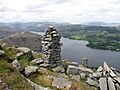
The view west from the summit over Ullswater and showing the Bonscale towers.

