
Green Gable facts for kids
Quick facts for kids Green Gable |
|
|---|---|

Great and Green Gable from Sprinkling Tarn. Green Gable is the smaller hump on the right.
|
|
| Highest point | |
| Elevation | 801 m (2,628 ft) |
| Prominence | c.50 m |
| Parent peak | Great Gable |
| Listing | Hewitt, Wainwright, Nuttall |
| Geography | |

Green Gable
Location in Lake District

Green Gable
Location in Allerdale

Green Gable
Location in the Borough of Copeland
|
|
| Location | Cumbria, England |
| Parent range | Lake District, Western Fells |
| OS grid | NY214107 |
| Topo map | OS Landrangers 89, 90, ExplorerOL4 |
Green Gable is a mountain, or "fell," in the amazing Lake District in England. It's often climbed by people on their way to its more famous neighbour, Great Gable. You can start your climb from places like Honister Pass, Seathwaite in Borrowdale, or Ennerdale. From the top, you get awesome views of Gable Crag, Scafell Pike, and the beautiful Buttermere valley.
Contents
Exploring Green Gable's Landscape
The mountains in the western part of the Lake District form a big triangle. Green Gable is part of this area. It stands near its larger sibling, Great Gable. These mountains are like a giant horseshoe shape around the long, wild valley of Ennerdale. Green Gable is found to the northeast of Great Gable.
How Green Gable Got Its Name
Green Gable and Great Gable stand at the very top of Ennerdale valley. A small river called Liza starts here. It tumbles down from the low point between the two mountains, known as Windy Gap. On the other side, they have a popular walking path called Sty Head. This path connects the valleys of Borrowdale and Wasdale.
Green Gable gets its "gabled" shape from the Ennerdale side. A "gable" is the triangular part of a wall, like on a house. Even though it's called "Green Gable," only the lower parts are green. The top is mostly covered in stones.
Nearby Ridges and Valleys
If you think of Great Gable as the center of the Western Fells, Green Gable is the start of the northern arm. This arm then stretches over to other fells like Brandreth and Haystacks. Green Gable also has another ridge that goes northeast. This ridge ends at a separate fell called Base Brown.
Windy Gap and Sty Head
Windy Gap is a low point (about 2,460 feet high) just southwest of Green Gable's summit. It's at the bottom of a rocky slope. On the Ennerdale side, you'll find Stone Cove, which is full of deep stones. The path going southeast from Windy Gap leads down a rough chute called Aaron Slack. "Slack" is a local word for a rocky slope. This path takes you down to Sty Head Pass.
At the bottom of Aaron Slack is Sty Head Tarn. A tarn is a small mountain lake. This one is a large pool in a hollow, with its outlet blocked by big rocks. It's about 30 feet deep and people say it has trout fish in it!

Waterways and Features
On the eastern side of Green Gable, there's a small hollow called Mitchell Cove. Its stream joins Styhead Gill, which flows towards Borrowdale. In the northern corner, where the ridge connects to Base Brown, there's a flat, low area called Blackmoor Pots.
The valley between the Base Brown and Brandreth ridges is called Gillercomb. This is a classic "hanging valley," which means it's a valley that's higher up than the main valley it joins. The stream from Gillercomb, called Sourmilk Gill, flows down a series of waterfalls near Base Brown and into Seathwaite. This means almost all the water from Green Gable eventually reaches the River Derwent.
Brandreth connects to Green Gable through a narrow ridge called Gillercomb Head. You might find small pools here after it rains. The Ennerdale side of Green Gable has the gentlest slopes, especially lower down. A long, grassy path called Tongue gradually goes up the mountain. However, the very top part is protected by Greengable Crags, which are steep cliffs stretching from Stone Cove.
What Green Gable is Made Of

The very top of Green Gable is covered by a type of soil and rock mixture called till. But if you look closely, especially to the west and north, you'll see rocks from the Long Top Member. These rocks are made of rhyolitic tuff and lapilli-tuff, which are types of volcanic rock formed from ash and small fragments. Near Sty Head, you can find Scafell dacite and other volcanic rocks like tuffs and breccias from the Lingmell Formation. There's no history of mining on Green Gable.
The Summit Views
Green Gable has a neat top marked by a pile of stones called a cairn. It would be a very famous spot on its own if it weren't for the huge presence of Great Gable right next to it! From the summit, you get a perfect view of Gable Crag. In every other direction, the views of the Lakeland fells are amazing. The view looking up the Buttermere valley is perhaps the best part.

Climbing Green Gable
Many of the paths used to climb Great Gable also pass by Green Gable. If you start from Seathwaite, a path goes up next to Sour Milk Gill and into Gillercomb. From there, it continues up the side of the Blackmoor Pots ridge and right to the summit.
If you start from the top of the Honister Pass road, a path goes around Grey Knotts and Brandreth. Then, it climbs Green Gable via Gillercomb Head. This path can also lead you to Moses Trod. Moses Trod is a high-level route from Honister to Wasdale. "Moses" was a legendary local figure, possibly a quarry worker from Honister who also traded goods and maybe even smuggled whisky between the valleys!
Another way to climb Green Gable from Seathwaite is to go up Styhead Pass. Then, you can turn off into Mitchell Cove and follow the stream almost to the top. You can also use the Aaron Slack path.
If you're starting from Ennerdale, you'll have a long walk up the valley. This can lead to a climb up Stone Cove to Windy Gap, or an easier climb up the Tongue path to reach Gillercomb Head. You can also climb Green Gable indirectly by going over Brandreth or Base Brown first.
Images for kids
-
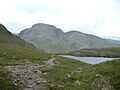
Great and Green Gable from Sprinkling Tarn. Green Gable is the smaller hump on the right.
-
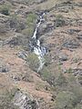
Sourmilk Gill, Seathwaite
-
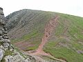
Summit of Green Gable, from the Great Gable path - showing rough track down to Windy Gap.
-
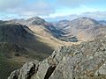
Looking NW from Green Gable summit down the Ennerdale valley.
