Silver How facts for kids
Quick facts for kids Silver How |
|
|---|---|

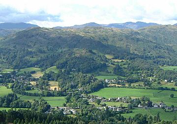
Silver How above Grasmere village
from Stone Arthur |
|
| Highest point | |
| Elevation | 395 m (1,296 ft) |
| Prominence | c. 30 m |
| Parent peak | Harrison Stickle |
| Listing | Wainwright |
| Geography | |
| Location | Cumbria, England |
| Parent range | Lake District, Central Fells |
| OS grid | NY325066 |
| Topo map | OS Explorer OL7 |
Silver How is a cool hill, or "fell," found in England's beautiful Lake District. It stands tall above the pretty village of Grasmere. The word "How" comes from an old language called Old Norse, where "haugr" meant a hill or mound. It's a common word for hills in this area!
Contents
Exploring Silver How's Shape
Silver How is part of a longer line of hills called the Blea Rigg ridge. It might just seem like one of many bumps on that ridge. However, a famous fell-walker named Alfred Wainwright thought it was special enough. He gave it its own chapter in his popular book, Pictorial Guide to the Lakeland Fells.
The Ridge and Its Views
To the west of Silver How, the ridge gets higher. It goes over several smaller tops like Lang How and Great Castle How, heading towards Blea Rigg. To the south and east of the top, the ridge gets narrower and drops down. This area is a wooded dip called Red Bank. After that, it rises again to another hill called Loughrigg.
The eastern side of Silver How, above Grasmere, is quite steep. Trees grow up to about halfway, and then the final climb to the top is rocky. This is the view that makes the fell so popular. You can see it really well from Grasmere lake. Many footpaths cross this ridge, making it great for walkers and photographers. There are also rocky cliffs on the southern side, looking over Chapel Stile in Great Langdale.
Waterways and Pathways
The Grasmere side of the fell has a stream called Wray Gill. This stream forms the northern edge of Silver How. It curves around and flows directly into Grasmere lake. Another stream, Meg's Gill, marks the eastern boundary. It drops through a deep valley above Elterwater village.
Below the eastern end of the fell, near Dow Bank, there's a dip called Red Bank. A road runs through here, connecting Grasmere to Langdale. It's a very scenic drive! Near the highest point of this road is High Close Youth Hostel, surrounded by trees.
Reaching the Top of Silver How
There are many paths on Silver How, and lots of rounded hilltops. This can sometimes make it a bit tricky to find your way. The true summit, or highest point, has a large pile of stones called a cairn. It sits right above Grasmere village.
Amazing Views from the Summit
From the top, you get fantastic views all around! The best part is seeing Grasmere lake and its valley below. Behind it, you can see the Fairfield horseshoe hills. You can also get a good look at the Langdale Pikes and the Coniston Fells.
Ways to Climb Silver How
You have many choices for climbing Silver How! You can start your walk from Grasmere, Chapel Stile, Elterwater, or High Close. The paths from Grasmere offer beautiful scenery all the way up. The path from Elterwater starts in a less exciting area. The shortest way to the top is actually from Chapel Stile.
You can also combine your walk up Silver How with a longer hike to Blea Rigg. If you do this, New Dungeon Ghyll in Great Langdale becomes another possible starting point.
 | Madam C. J. Walker |
 | Janet Emerson Bashen |
 | Annie Turnbo Malone |
 | Maggie L. Walker |


