Sallows facts for kids
Quick facts for kids Sallows |
|
|---|---|
 |
|
| Highest point | |
| Elevation | 516 m (1,693 ft) |
| Prominence | c. 69 m |
| Parent peak | Ill Bell |
| Listing | Wainwright |
| Geography | |
| Location | Cumbria, England |
| Parent range | Lake District, Far Eastern Fells |
| OS grid | NY437040 |
| Topo map | OS Explorer OL7 |
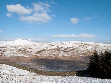
Sallows is a type of mountain called a fell in the beautiful Lake District area of England. It stands tall between two valleys, Kentmere and Troutbeck. It's the highest point in the hills south of a path called Garburn Pass. Maps sometimes call this area Kentmere Park or Applethwaite Common.
Contents
Exploring Sallows and Nearby Areas
Sallows and another fell called Sour Howes look like a horseshoe shape when seen from above. The open part of the horseshoe faces southeast. This area collects water for Park Beck, which is a small stream that flows into the River Kent. Sallows is located north of Park Beck. It connects to the top of the small valley through a ridge called Moor Head.
The southern side of Sallows, just above Park Beck, is smooth and covered in grass. You can still see the remains of an old quarry there. A path that was used to reach the quarry still exists, making it an easy way to climb Sallows from the east.
Slopes and Valleys
The eastern part of Sallows gently slopes down for about half a mile towards the Kent valley. There are a few small rocky cliffs, especially on a spot called Scour Rigg. The high ground then turns south at a smaller peak called Mould Rigg, which is about 350 meters high. It finally flattens out where Park Beck meets the River Kent. The slopes above the River Kent are steep and covered mostly with trees.
Below these trees, the river spreads out into a strangely shaped lake called Kentmere Tarn. This lake used to be natural, but it was drained in the 1830s to create more farmland. However, this plan didn't work very well and just created a marshy area. Later, people discovered that the bottom of the tarn was rich in a mineral called diatomite. This mineral is used to make things that block heat, like insulation. People started digging out diatomite in the 1930s and continued until 1971. This digging created the shape of the man-made tarn we see today.
Garburn Pass: An Old Route
To the north of Sallows is Garburn Pass. This was an old path used by people walking or riding horses to trade goods between Troutbeck and Kentmere. It's now called a "Restricted Byway," which means certain types of vehicles can use it, but not all.
Between 2006 and 2009, it was a "bridleway," meaning horses and bikes could use it. However, many off-road vehicles also used it, which caused arguments between drivers and walkers. Because of this, it was changed to a "restricted byway" to manage its use better. From the highest point of the pass, called Garburn Nook (about 447 meters high), the land rises northwards along a wide ridge towards Yoke and Ill Bell.
The Summit of Sallows
The very top of Sallows is covered in grass and heather. The highest point has a curved ridge of shale rock, about nine meters long. On this ridge, there's a small pile of stones called a cairn. From the summit, you get a great view to the west, where you can see the Scafell mountains and the Old Man of Coniston groups. On a clear day, you might even see as far as Black Combe and the Pennines in the distance!
How to Climb Sallows
You can easily reach Sallows from the top of Garburn Pass. You can also climb it from Kentmere or Ings by following the old quarry track. There's also a narrow path that goes around Moor Head to Sour Howes. This path allows you to make a circular walk around Park Beck, which is a fun way to explore the area.
 | Tommie Smith |
 | Simone Manuel |
 | Shani Davis |
 | Simone Biles |
 | Alice Coachman |


