
Dale Head facts for kids
Quick facts for kids Dale Head |
|
|---|---|

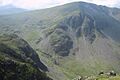
Dale Head seen from the neighbouring hill of High Spy
|
|
| Highest point | |
| Elevation | 753 m (2,470 ft) |
| Prominence | 397 m (1,302 ft) |
| Parent peak | Great Gable |
| Listing | Hewitt, Marilyn, Nuttall, Wainwright |
| Geography | |

Dale Head
Location in Lake District

Dale Head
Location in Allerdale
|
|
| Location | Cumbria, England |
| Parent range | Lake District, North Western Fells |
| OS grid | NY223153 |
| Topo map | OS Landrangers 89, 90, Explorer OL4 |
Dale Head is a cool mountain, also called a fell, located in the Lake District in northern England. It's super tall, reaching about 753 meters (that's 2,470 feet!) above sea level. You can find it just north of Honister Pass, which is a road connecting two beautiful valleys: Borrowdale and Buttermere.
Contents
What is Dale Head Like?
Dale Head is the highest mountain in the southern part of the North Western Fells. These fells are a group of hills shaped like a long oval, found between two rivers called the Derwent and the Cocker.
Where Does Dale Head Get Its Name?
Dale Head gets its name because it sits at the very top, or "head," of the Newlands Valley. This valley stretches north for about three and a half miles. The eastern side of the valley is formed by a ridge of mountains including High Spy and Catbells.
What Ridges Connect to Dale Head?
Dale Head is like a central point where two main mountain ridges begin.
- One ridge goes northeast and includes other famous fells like High Spy, Maiden Moor, and Catbells. This ridge forms the western side of Borrowdale valley and looks over Derwent Water.
- The other ridge goes northwest and includes the fells of Hindscarth and Robinson. This ridge overlooks Gatescarthdale and Buttermere.
What Are the Slopes of Dale Head Like?
The northern side of Dale Head, which forms the head of the Newlands Valley, has steep, rocky cliffs called crags. Some of these are named Dalehead Crags.
The southern side of the mountain slopes down more gently towards the top of the Honister Pass road. Even here, you can see some rocks sticking out, like Buckstone Hows and Yew Crag. From the top of the pass, water flows in two directions: Gatesgarthdale Beck goes northwest towards Buttermere, and Hause Gill flows east towards Seatoller and Borrowdale.
The ridge connecting Dale Head to Hindscarth is called Hindscarth Edge. It gets quite narrow and rocky, making for an exciting walk!
Are There Any Lakes on Dale Head?
Yes, Dale Head has two small mountain lakes, called tarns.
- Dalehead Tarn: This shallow tarn is on the northern slope, near where Newlands Beck begins. It's a popular spot for walkers to stop and rest. You can see different plants growing here, like water horsetail and sedge.
- Launchy Tarn: This tarn is smaller and is located near the top of High Scawdel, which is an eastern part of Dale Head.
What is Dale Head Made Of?
Dale Head is a special place for geology because it's where two major types of rocks in the Lake District meet.
- The northern parts of the mountain are made of Skiddaw slates.
- The southern parts are made of Borrowdale Volcanics, which are rocks formed from ancient volcanoes.
What About Mining History?
Dale Head has a long history of mining.
- Dale Head Mine: This mine was dug into the northern cliffs to find copper. You can still see some of the old tunnels today.
- Long Work: Another copper mine, this one was worked for minerals like malachite and pyrite way back in the Elizabethan times (over 400 years ago!).
- Honister Quarries: These are huge underground quarries on the southern side of the mountain, near Honister Pass. They were dug to get a special type of rock called Green Slate. People have been working here since at least 1728! The Yew Crag workings on the Dale Head side were used until 1966.
There was even a plan in 1887 to dig a tunnel right under Dale Head to connect to a railway, but it was never finished. The main building where the quarry workers used to live is now the Honister Hause Youth Hostel.
Reaching the Top of Dale Head

The very top of Dale Head has a pile of stones called a cairn. From here, you get an amazing view! You can look straight down the Newlands Valley to the north, with the large mountain Skiddaw in the background. All around you, you'll see many other fells stretching out in every direction.
How Can You Climb Dale Head?
One of the most popular ways to climb Dale Head starts from the top of Honister Pass. There's a car park and a youth hostel there. This route goes straight up next to a fence for about 2 kilometers and usually takes walkers about 45 to 50 minutes.
You can also start longer walks from Little Town in the Newlands Valley. These routes might go past Dalehead Tarn or follow the old path that led to the Dale Head Mine. If you're starting from Borrowdale, you can begin at Seatoller or Longthwaite and climb up past Launchy Tarn and High Scawdel.
Images for kids
-
Dale Head seen from the neighbouring hill of High Spy
-
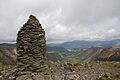
The view of the Newlands Valley and Skiddaw from Dale Head summit cairn.
